The Military Campaigns of Suleyman the Magnificent:
Animation and Interaction as Space/Time Transformations
Sandra Lach Arlinghaus

OVERVIEW:  TIME AND SPACE

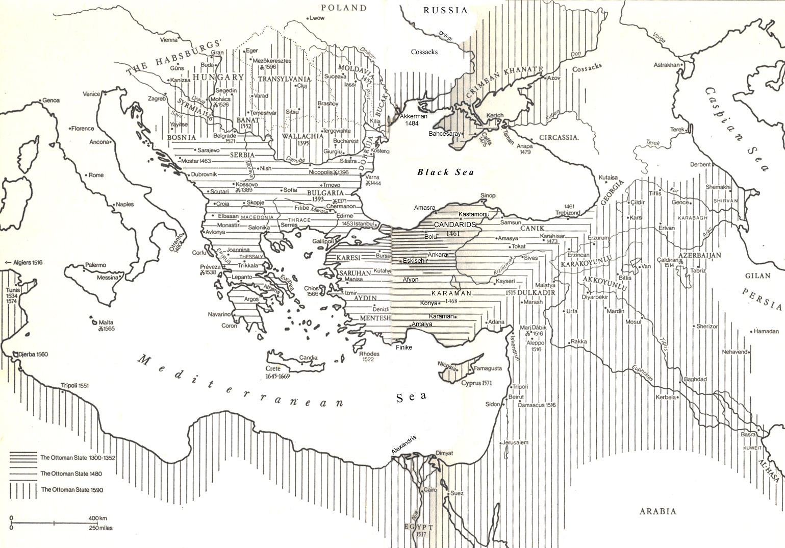
Classical period of the Ottoman Empire c. 1300-1600
Circumscribing the life and times of Suleyman the Magnificent 1481-1598
Life Span of Suleyman the Magnificent 1494-1566
Reign of Suleyman the Magnificent 1520-1566


Military Campaigns of Suleyman: 
Timeline of Selected Events

1521--Conquest of Belgrade
1522--Fall of Rhodes
1523
1524
1525
1526--Battle of Mohacs
1527
1528
1529--Siege of Vienna
1530
1531
1532--Siege of Guns
1533--Two Iraqs Campaign
1534--Conquest of Baghdad; Battles of Tunis
1535--Battles of Tunis
1536
1537--War with Venice; Siege of Corfu
1538--Naval Battle of Preveza
1539
1540--Peace with Venice
1541
1542
1543--Siege of Nice
1544
1545
1546
1547
1548--Conquest of Van
1549
1550
1551
1552
1553
1554--Campaign in Iran
1555
1556--Hungarian Campaign
1557--Hungarian Campaign
1558--Hungarian Campaign
1559--Hungarian Campaign
1560
1561
1562
1563
1564
1565--Siege of Malta
1566--Siege of Szeged
 
The pages above contain numerous links to important participants and to electronic references, timelines, and bibliographies.
In addition to the hundreds mounted there, the following link contains a few extra references not found elsewhere.

OVERVIEW:  SPACE AND TIME
BOUNDARIES CHANGE THROUGH TIME FROM HUMAN DECISIONS...


The Ottoman Empire in a global context: an animated scene showing general spatial change through time.  The yellow boundary represents the extent of the Ottoman Empire by 1352; the orange boundary represents its extent by 1480; and, the red boundary represents its extent by 1590.  To see a QuickTime movie version of the animated map above, in which the user can control the rate of movement, click here.

Scale chart for all maps on this site to give approximate distances (as the crow flies), independent of projection and other factors:
Istanbul to East end of Black Sea is 650 miles
Istanbul to Northern tip of Black Sea is 400 miles
Istanbul to Rhodes is 330 miles
Istanbul to Sofia is 320 miles
Istanbul to Vienna is 800 miles
Istanbul to Alexandria is 675 miles
Istanbul to Baghdad is 990 miles
Istanbul to Tunis is 1000 miles

TOPOGRAPHY MAY SHAPE HUMAN DECISION-MAKING


This map is built in Adobe Photoshop from scanned images, used as a base map, from Inalcik (pages 24 and 25).  Hot spots have been added to make the map clickable.  Run the mouse over the map, and click, to see the close-ups come up in a new frame.  Useful older maps can be adapted to new scenes and enhanced with extra information.


PARTICIPANTS:  GENEALOGY OF THE OTTOMAN DYNASTY
(After Inalcik, pp. 204-205)
Applets offer visual evidence of temporal pattern. When the line segments joining adjacent rectangles are scaled according to time, additional information is transformed into a spatial format. Another interesting view of the applet is as a dynamic object that represents the stability, or lack thereof, in a system. Scramble the applet; does it settle down to a steady state? The size of the bounding box helps to determine the steadiness of the system--there are many parallels to these ideas in human systems. Move the red "start" box--try moving it to the lower right corner of the display. Move other parts of the applet as you wish, to expose names or genealogical structure.  Notice the strong linear pattern in earlier times with more fragmentation of pattern in more recent times.   Does that pattern mirror the fragmentation and decline of the Ottoman Empire?

alt="Your browser understands the <APPLET> tag but isn't running the applet, for some reason." Your browser is completely ignoring the <APPLET> tag! 

Citing this site

Copyright of the content provided on each link belongs to the creator of that site. Copyright of the information cited from magazines, newspapers and books belongs to the publisher unless it is a work in public domain. U.S. Copyright information.