
map project
 |
 |
|
figure 1:
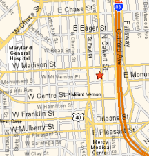
740 Calvert St., Baltimore (a YAHOO! map) |
figure 2:
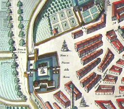
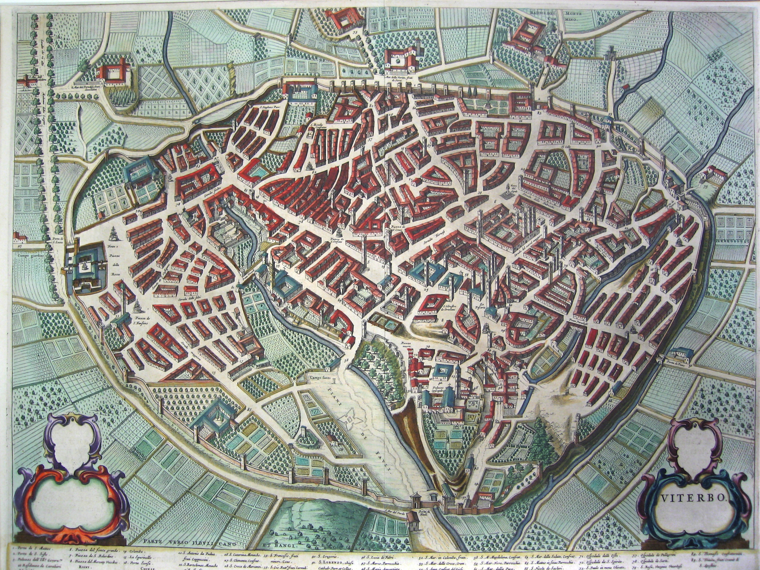
detail: bird's eye view of Viterbo, Italy | full map |
What is a map? What does a map tell us? Maps can give us information about where we are and how to get from one place to another.
Figure 1, above, is an online street map. It clearly illustrates a complex network of streets and highways, and gives us a sense of approximate distance. Important landmarks, such as hospitals, are named but are not otherwise represented graphically.
Figure 2 conveys the same sort of information and much more, including painstakingly detailed depictions of buildings, trees, and crops. It is possible to imagine walking around this place, entering buildings and strolling through gardens. Click to see the full map and to take a quick tour around the city of Viterbo.
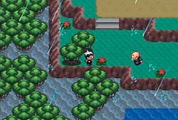
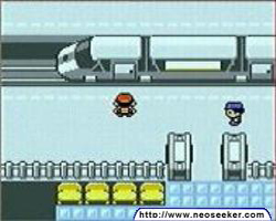
Compare the two maps represented in the figures above. Do they communicate the same emotional tone?Below are two screenshots from Nintendo GameBoy games. Compare these and other GameBoy screenshots to the old map of Viterbo, Italy. Notice the common use of a bird's eye (oblique) point of view. Are there other similarities?
 |
 |
|
figure 3:
GameBoy screenshot | more screenshots |
figure 4:
GameBoy screenshot (pokemon silver GBC) |
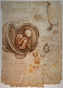
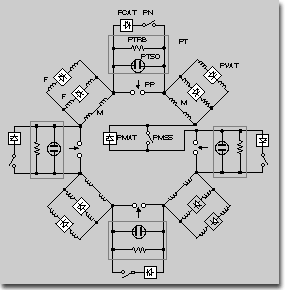
Look at the two images below: an anatomical drawing and a circuit scheme. Would you consider these drawings "maps?" Why?
 |
 |
|
figure 5:
Leonardo DaVinci: fetus in womb |
figure 6:
RFX poloidal circuit scheme | more information |
Look at more maps. I've posted two sets of images for you to study. While looking at the maps, consider what else a map can covey besides placement and distance.
Set A thumbnails: a selection of maps found in the U of M map library. Click on the images to see the map in higher resolution.
Set B thumbnails: a selection of maps from the book, You Are Here: Personal Geographies, by Katharine Harmon. Many of these are "artists' maps." High-resolution versions of these maps are available in the RESOURCES folder of the CTools site for this class.
Things to consider:
Look at the two What's Up? South! maps (California and the world). Point of view is important. Maps are generally oriented with north at the "top," but is this necessary? What sort of bias might be conveyed in our acceptance of this convention? What is the effect on the viewer when a map is drawn "upside down?"
Examine all the maps, considering graphic elements like pictures and the lettering on the map, as well as distortion and point of view.
Ask yourself: What does the peculiar distortion of the Whimsical Great Lakes Projection convey to the viewer?
Look at Jo Mora's picture map of Carmel, California. The cartographer is not only describing the streets of the city, but its inhabitants (past and present) as well, including dogs.
Consider the point of view of the implied map "author" in A Dog's Idea of the Ideal Country Estate.
assignment
NEW DUE DATE: last class of session one, Monday, February 21
Here is the text of the original assignment. You may stick with this assignment if you wish. Alternatively, you may choose this revised assignment:
revised assignment:
After looking at all the maps posted on this site and on CTools, as well as the maps in the map library, you probably have some idea of how artists have used maps and how you, as an artist, might use the language of the map in your own work.
You have already made one map, from memory, of one of the places you lived in the past. These maps described both places and events particular to you. A similar map would be The Walk to South School, 1964-1971 (on CTools).
For this project, draw a series of maps (2-10) illustrating and explaining some aspect of your life, present or past, or even an imagined future. Here are a few ideas which might stimulate your imagination:
1. "The steps I took in my grand effort to evolve from boyhood to manhood."
2. "After becoming a woman far too soon, the steps I took to regain my childhood."
3. "My tattoos: where I have them, where I got them, what they look like, and what they mean."
4. "How I went from being a D student to becoming an A student."
5. "What I'll be at age 80 and how I'm going to get there: a gameboy rpg"
6. "All the places I've lived, what my room looked like, and what pets I had."
7. "How and why I became an alcoholic."
8. "How I plan to save the world."
9. "All the boyfriends/girlfriends I've had and the paths they took in life after they left me/I left them."
10. "My favorite novels and the towns they took place in and how to get from one place to another."
11. "A practical map of the kitchen."
requirements:
A SERIES of MAPS
This is your only project for this half-semester, and should reflect the equivalent of a 5-week effort.
Think of ideas that require a series of maps. For example, if you choose option 11, above, you could map three kitchens, and therefore have 3 maps. Or perhaps, you might draw one over-all view of one kitchen, then draw 3 or 4 detail maps showing such things as the interior of a cabinet or a drawer, or even the plumbing system.
MATERIALS
I asked you to get the following supplies. These are fine materials for the execution of your project and are available at Art Warehouse or Michigan Book and Supply:
• Strathmore Plate Finish Series 500 3-to-5 ply Bristol paper (20 x 30 inches, 2 sheets)
alternative: "Rising" brand artist bristol, 3 or 4 ply, 22 x 30"
• Speedball Pen set-- Mapping nibs.
• Waterproof India ink (Winsor-Newton with a spider on the box is good)
alternative: Higgins Black Magic (not quite as dark or waterproof as Winsor-Newton)
• water jar
• cloth for wiping nibs
• pencils
• erasers
• watercolor set
• BRUSH for ink: Winsor-Newton series 7 #1 or equivalent sable brush
• Brushes for watercolor
Alternative materials:
Large sheets (20" x 30", 30" x 40") of graphing paper and mechanical pencil or pen and ink.
-or-
any other drawing materials you can think of.
FORMAT:
Give this some thought. I encourage you to take a traditional, wall-map-type approach, but if you are motivated, you are free to take another approach.
Folding maps, origami maps, scroll maps... 3-dimensional maps...animated maps... anything is possible. But remember, this is a drawing class. Content and the execution of your drawings, therefore, should be the most important aspect of your work.
more resources
U of M map library
Librarians: Karl Longstreth (karleric@umich.edu) and Tim Utter (tutter@umich.edu)
The librarians will help you find whatever you need. Just ask. Talk with them in person or give them a call or drop them an e-mail. If you want to make copies of maps, there is a scanner at the library. You may also bring a camera to take pictures of maps.
Library Hours: 10-6 M-F, Sunday 1-4, or by appointment: 764-0407
recommended reading/references:
You Are Here: Personal Geographies by Katherine Harmon
Princeton Architectural Press; 1st edition (November, 2003)
Couleurs de la Terre: Des mappemondes médiévales aux images satellitales
175 pages, Bibliothèque nationale de France (1998)
ISBN: 2020354292
The Visual Display of Quantitative Information, by Edward R. Tufte
Graphics Press, 2001
links
Mark Harrower's Web Site (animated maps and more)
http://www.geography.wisc.edu/~harrower/index.html
GeoPlace (source of geospatial data): http://www.GeoPlace.com
National Atlas (great source of data about the US): http://www.nationalatlas.gov/
Oddens' Website - The ULTIMATE Guide to Cartography on the Web!
http://oddens.geog.uu.nl/Old/ODDENS.HTM
TopoZone - Provides seamless, viewable and searchable USGS topographic maps of the United States on the Web.
http://www.topozone.com/
MapQuest. - The leader in "On-Demand" Cartography: http://www.mapquest.com
Maps.com - The Place for Maps: http://www.maps.com
Environmental Systems Research Institute, Inc : ESRI: http://www.esri.com
UW-Madison Department of Geography: http://www.geography.wisc.edu/
GeoVISTA Center at Penn State: http://www.geovista.psu.edu
AND MANY MANY MORE:
http://www.lib.umich.edu/maplib/web_resources.htm