FREE ALLEN’S CREEK!
by Jim Nicita
Ann Arbor is witnessing a groundswell. The community has undertaken a campaign to "Free Allen’s Creek!"
To free Allen’s Creek from its ignominous confines within an aging, inadequate storm drain. To free Allen’s Creek from its status as a flooding disaster-in-waiting. To free Allen’s Creek from its role of contributing the heaviest concentration of phosphorus and other pollutants of any tributary of the Huron River in Washtenaw County. To free Allen’s Creek from its obscurity.
How The Creek Was Lost: A Long Story Made Short
Many residents of the South and West sides of Ann Arbor do not realize that they live in a creekshed. Where is the creek? It is still there, but now it runs mostly through underground storm drains. We who live above Allen’s Creek may wonder at and enjoy the ravines that characterize our neighborhoods, and complain about the flooding in our streets and basements, yet never know that we live on top of a creek.
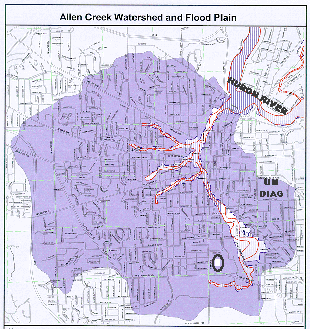
The Allen’s Creek watershed is a bowl-shaped catchment area that generally covers the South and West sides of Ann Arbor, and much of the University of Michigan’s central campus area. The main stem of the creek begins near Pioneer High School, runs underground roughly parallel to the route of the Ann Arbor Railroad, and enters the Huron River just below the Argo Pond dam. Three primary branches rise westward from the main stem: the West Park - Miller Drain, the Murray-Washington Drain, and the Eberwhite Drain. Remaining traces of open creek can be found at the University of Michigan golf course, in the Liberty-Glendale neighborhood, and through Eberwhite Woods.
Named in 1824 after one of Ann Arbor’s founders, John Allen, the creek during the city’s first century helped define the city’s very identity. When Allen and Elisha Rumsey set up their camp near what is now the corner of First and Huron, the creek was right behind them as a water source. As the century progressed, industries that required water located near the creek: a flour mill, tanneries, a foundry, and breweries, for example. The flat topography of the Allen’s Creek valley, and the industries in this valley, led the Ann Arbor Railroad in 1878 to locate its tracks parallel to the creek.[1] By century’s end, then, the pastoral nature of the lower Allen’s Creek valley had changed to an industrial one, and the water quality and ecosystem of the creek diminished.
What is now Ann Arbor’s Old West Side developed through the late nineteenth and early twentieth century. With this development came more sources of pollution to the creek. The development also created what is known as "imperviousness," areas such as rooftops, driveways, and roads, where instead of percolating into the ground the water rushes off the surface into a creek or stream. This runoff causes flooding, harms stream banks and stream wildlife, and carries pollution—phosphorus off of lawns, auto grease and oil off streets—with it. By the city’s centennial in the early twenties, property owners were demanding that the city put the creek into a storm sewer.
The main stretch of the creek was piped in 1926, and the lower segments of the main branches shortly thereafter. As growth has continued through to the present, it has created even greater levels of imperviousness. A significant concentration of imperviousness, for example, can be found in the commercial corridors of Maple and Stadium boulevards, in the Allen’s Creek headwaters. Over the years this imperviousness has contributed to major flooding, as in 1947 and 1968, and the localized flooding many of us see in our basements frequently during big rainstorms. The increased rates of runoff have also damaged stream channels, which has occasioned further piping projects such as the controversial Liberty-Glendale project in 1997.
The Allen Creek’s watershed has become nearly fully developed, and now massive storm runoff is stressing the aging, inadequate system. The public policy response to this urgent situation has to date come up short. It is a history of squandered opportunities, band-aid repairs, and insufficient analysis. For example, in the wake of the 1968 flood, a proposal emerged in the 1970s to construct a storm water detention facility off Liberty Street, near Virginia Park. Not only was this facility never built, the city allowed more imperviousness in the form of a condominium project to be built on the site. In the 1980s, voters approved a $1.1 million bond issue, a sum that could only provide patchwork maintenance. In the mid 1990s the city contracted with the engineering firm of Black & Veatch for a Storm Water Master Plan. In disregard of the innovative, holistic, watershed-based concepts for storm water management emerging during this period, the plan concentrated instead on a hardware-intensive, "big pipe" solution to the problem. The plan estimated that the cost of a full retrofit of the Allen’s Creek storm water system would be around $40 million: a high tab, and very probably underestimated. The plan has been ignored.
The history of the Allen’s Creek watershed has arrived at a significant juncture. The community faces a decision. On the one hand, we can devote a substantial investment to solutions providing updated storm water pipe infrastructure, which may not address water quality issues because a pipe system is designed to efficiently deliver the storm water, untreated, to the Huron River. On the other hand, we can seek ecosystem and watershed-based storm water management alternatives that may be less costly, and which may promote better water quality because they treat and purify the water before it reaches the Huron River. These watershed-based alternatives might include the "rain garden" system of storm water management that U-M Professor Joan Nassauer used to retrofit the town of Maplewood, Minnesota’s storm water infrastructure—at a much lower cost than with pipes. [2] It might include providing financial incentives to homeowners and businesses to replace their semi-impervious turf lawns with native plant species; install rain barrels; or convert their shingled roofs to rainfall-detaining green roof systems.
Many in the community, however, aspire to even more: not only to reduce flooding, and to improve water quality, but to restore Allen’s Creek fully as a community amenity for Ann Arbor.
Hydroknowledge Is Hydropower
It has taken over a century to create the problems that afflict Allen’s Creek, and it is going to take time for Allen’s Creek to evolve into an amenity—although it certainly need not take a century. The first step on this long hike is the knowledge of how Allen’s Creek works. Where the water flows, how it flows, how much water flows, when it flows. Over land, in the ground as groundwater, and through the storm drain pipes.
The experts call this a "hydrologic study." The University of Michigan recently completed a hydrologic study as part of its campus-wide storm water management plan. Such a study has also been undertaken for the Malletts Creek watershed, as part of the Malletts Creek Restoration Project. (www.co.washtenaw. mi.us/DEPTS/DRAIN/malletts/drnindex.html) No similar study has yet been done for Allen’s Creek.
A hydrologic study would be important for all three community objectives in Allen’s Creek: reducing flooding, improving water quality, and restoring the creek as a community amenity.
Take flooding, for example. The Malletts Creek hydrologic study generated an excellent water flow monitoring system. The flow meter in the creek generates real-time water flow information that one can observe on the web: (http://srvrdmilns.er.usgs.gov/rt-cgi/gen_stn_pg?station=04174518). Nothing similar exists for Allen’s Creek. Now, in Allen’s Creek one of many neighborhoods that experiences flooding is the North Central neighborhood, around Wheeler Park. The antiquated main branch of the storm drain runs right through this neighborhood. It gets full in a big storm, and overflows onto the street and into people’s basements. The main branch receives storm water from the three major sub-branches: West Park - Miller, Murray - Washington, and Eberwhite, which intersect the main branch up in the downtown area. But which of these branches is contributing the most? We do not know, because we do not have flow monitors in these branches. Thus, we might risk wasting large sums on upstream flood control in a branch of the storm drain that actually does not contribute that much to the storm water load in the first place. A hydrologic study would give us the information to ensure that we spend our limited resources on solutions that will be effective.
The story is similar for water quality. Water quality improvements come through techniques referred to as "best management practices," or BMPs. Typical BMPs are storm water retention ponds, which allow pollutants to settle out of water before the water continues on downstream. These ponds also serve flood control functions. In the Allen’s Creek watershed, because it is so developed, there remain few places to site retention ponds. One candidate is a large parcel between Liberty Street and Thaler Street, high in the watershed near the highly-impervious Stadium Boulevard commercial strip. But we do not know the hydrology of this site and its surrounding area. Is it too steep? Would water flow in the direction of the pond? A hydrologic analysis of the Allen’s Creek watershed would help us evaluate whether this and other sites can be used as storm water retention areas.
Allen’s Creek as an Amenity
Finally, a hydrologic study is crucial to restore Allen’s Creek as a community amenity.
There is a conventional wisdom in some quarters of Ann Arbor, even among certain watershed planning officials and professionals, that in an ultra-urban watershed like Allen’s Creek there is nothing to be done. The conventional wisdom would give up Allen’s Creek as a "lost cause."
Those espousing this conventional wisdom need to spend some time near a quiet stream, and contemplate the works of James Patchett and Herbert Dreiseitl. These two water visionaries have credible track records in using storm water runoff as an artistic and design amenity, precisely in ultra-urban areas.
Patchett, a former Ann Arborite and now head of the Conservation Design Forum in Illinois, wrote recently,
[T]o enclose stormwater in a pipe, and convey it away from the site as quickly as possible, is to fail at every level. Water should be collected, experienced for its beauty and function, cleansed, recycled, and absorbed on-site unless conditions dictate that it be dispensed elsewhere. [3]
Rain water can be collected off of rooftops and from a housing site, and directed into safe, artistically designed and vegetated open channels that meander overland through the interstices of the urban fabric.
This system creates, in Dreiseitl’s words, "an opportunity to provide an aesthetic experience for the city dweller while furthering environmental awareness and citizen interest and involvement." [4] Dreiseitl, who founded the Atelier Dreiseitl in Uberlingen, Germany, presents examples of many of his works on his website: www.dreiseitl.de. Patchett and Dreiseitl leave no doubt that their techniques and concepts depend upon an extensive knowledge of the hydrology and hydraulics of a watershed.
The Ann Arbor community group Urban Design Advocates, which includes architects and planners familiar with the work of Patchett and Dreiseitl, is developing a prospectus document outlining a vision for an Allen’s Creek greenway running from William Street down to the Huron River, and parallel to the Ann Arbor Railroad. The proposed greenway includes an open channel, a bicycle/pedestrian path, and park amenities. (The existing subterranean main branch of the Allen’s Creek drain would be left in place to handle the larger storm events.) The group will present its findings later in the summer.
Further upstream, Allen’s Creek might be brought out of the storm drain altogether. This process is known as "daylighting." In some places, daylighting would not be possible: for example, some homes and business have been built directly above the storm drain! However, in areas such as West Park, through which a branch of the storm drain runs, Allen’s Creek might be daylighted as a park amenity. The Rocky Mountain Institute has published a booklet, "Daylighting: New Life for Buried Streams," which examines the issue of daylighting. It can be downloaded for free as a PDF file off of this website: www.rmi.org/sitepages/pid172.asp. Again, stream daylighting depends upon knowledge of watershed hydrology.
Organizing for the Vision
There was much discussion in Ann Arbor in 1999 about Allen’s Creek and funding a hydrologic study, but these discussions did not bear fruit. City leaders ultimately did not see it as a priority.
A renewed effort is now underway, led by the grassroots. Neighborhood associations and community groups as varied as the Eberwhite Woods Committee, the American Institute of Architects, and the Huron Valley Greens have passed resolutions in support of the city funding an Allen’s Creek hydrologic study.
However, this year the city is in a budget crunch. While the city is laying off police and fire fighters, it is not about to spend $300,000 out of its General Fund for a hydrologic study of Allen’s Creek. How can a study be funded outside of the General Fund? One solution may be through a grant.
There remains $7-9 million in federal funds under the Federal Emergency Management Administration’s (FEMA) Flood Hazard Mitigation Program. The application package indicates that one can use these funds for the type of analysis that groups are seeking for Allen’s Creek. It requires a 25% local match, which might be assembled among, for example, the Ann Arbor Downtown Development Authority, the University of Michigan, and the City Water Utilities Department, the latter of which operates off its own funding stream (from a storm water utility fee charged on residential water bills) unconnected to the city’s General Fund.
Members of another community organization, the Allen’s Creek Watershed Group (ACWG) met recently with the new Utilities Director, Sue McCormick. McCormick has taken on the daunting challenge of putting the city’s storm water system infrastructure in order after years of neglect. She has courageously proposed a 19.57% increase in the city’s storm water rates to fund long-overdue improvements. The Ann Arbor City Council will consider approval of this request in early June. While McCormick was very frank with the ACWG that her department does not currently have the funds to finance a hydrologic study for Allen’s Creek, she did agree to calculate hypothetical incremental increases in her proposed new water rates. The additional increments would finance her department’s contribution to the 25% local match for a grant application for the FEMA funds to finance a hydrological study. The results of her calculations, which she presented to City Council during a recent budget hearing, is that it would only take an additional 1% over the 19.57% proposed increase, or about 25 cents per person, to finance the hydrologic study.
It must be kept in mind that as expensive as a hydrologic study will be, and as difficult as it has been so far to generate the will in City Hall to finance such as study, the study will be only the first step in a long and costly process to improve the condition of Allen’s Creek. But, two points must be made in this regard. First, if the city does not pay proactively to address the severe problem it faces in Allen’s Creek, it will likely pay more retroactively in court costs. Compared to 1947 and 1968, when the last really major floods occurred, the upper watershed has been almost completely paved over, so there is more imperviousness and more runoff. Therefore, the next major flood will likely cause significantly more damage. And now, courts have augmented the city’s potential for liability in cases of floods. These financial damages would likely make those paid out in the sewer backup and substitute teacher cases look small by comparison. We cannot afford to be unprepared.
Second, grant money outside of the city exists to make improvements in Allen’s Creek. The FEMA Flood Hazard Mitigation program has already been mentioned. Regarding water quality, the Clean Michigan Initiative provides the most significant outside funding. In the cases of both flooding and water quality improvements, however, it is necessary to have detailed knowledge of the system through a hydrologic study. Otherwise, we cannot be sure that a particular measure is going to work, and thus we risk throwing money—to use a bad pun—down the drain.
It will take a concrete show of public support to advance the Allen’s Creek issue. No elected official likes to raise taxes, or water rates for that matter. So if, for example, the City Council is going to raise the storm water rates, to say nothing of an extra 1% for a city contribution to a local match for an Allen’s Creek hydrological study match, they are going to need public support to back them up. The same goes for the future funding of the remedial measures for Allen’s Creek that the hydrologic study will reveal as necessary.
But the vision of Allen’s Creek as a community amenity is powerful and inspirational. It is this vision that will generate the collective will to transform the creek’s status from problem to community amenity.
FREE ALLEN’S CREEK!
[1] Shackman, Grace, the Rise and Fall of Allen’s Creek The Ann Arbor Observer, June 1993.
[2] Nassauer, Joan Iverson, Brady Halverson, and Steve Roos, "Bringing Garden Amenities into Your Neighborhood: Infrastructure for Ecological Quality. A Guidebook for Cities and Citizens." University of Minnesota Dept. of Landscape Architecture, 1997.
[3] Patchett, James, "Letter from the Chair," American Society of Landscape Architects Professional Interest Group on Water Conservation, Vol. III, No. 1, Spring 1999, p. 3.
[4] Dreiseitl, Herbert, "The Role of Water in Our Cities — an Introduction to Our Work," American Society of Landscape Architects Professional Interest Group on Water Conservation, supra, p. 4.
Signed Elements ©
Individual Authors
Unsigned Elements © Agenda Publications, LLC