
PhD student at Civil and Envir. Eng.
University of Michigan
1318 G.G. Brown Building
2350 Hayward Street
Ann Arbor, MI 48109-2125, USA
Phone (734)5465327
yongxiao@umich.edu
Currently, I am a PhD student in the Department of Civil and Environmental Engineering at University of Michigan and a member of the Laboratory for Interactive Visualization in Engineering (LIVE), working with Professor Vineet R. Kamat. My research interests lie in the field of computer graphics, computer vision,and robotics. I am particularly interested in 3D perception, 3D scene understanding and their application in engineering.
Education
I am now pursuing a PhD degree in civil engineering. Meanwhile I am also on the way to a master degree in Robotics and Autonoumous Vehicles.
In 2013 I obtained my master degree in Cartography and Geographic Information System, at Institute of Remote Sensing and Digital Earth, Chinese Academy of Sciences, Beijing, China, with the supervision of Cheng Wang. In 2010 I got my bachelor degree in Geodesy and Geomatics, Wuhan University, Wuhan China .
Here is my curriculum vitae (last updated: Jan. 2015).
| 2012-2013 |
|
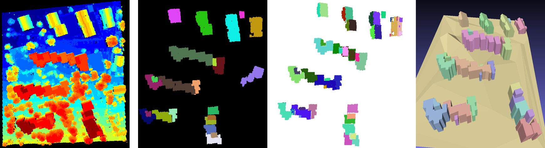
Building
segmentation and modeling from
airborne
LiDAR data
Xiao, Y.,
Wang, C., Li, J., W. Zhang, Xi, X., Wang, C. and Dong, P.
(2014). Building Segmentation and Modeling from Airborne
LiDAR Data. International Journal of Digital Earth.
doi:10.1080/17538947.2014.914252. Xiao , Y., Wang, C., Xi, X. and Wang F. (2014, in Chinese). Research on 3D Building Model Reconstruction from Airborne LiDAR data. Science of Surveying and Mapping, 6.Xiao, Y., Wang, C., Xi, X., Zhang, W. (2013). A Comprehensive Framework of Building Model Reconstruction from Airborne LiDAR Data. IOP Conf. Ser.: Earth Environ. Sci. 17. doi:10.1088/1755-1315/17/1/012178. Li, J., Xiao, Y., Wang C. (2013). Quality Assessment of Building Roof Segmentation from Airborne LiDAR Data. 2013 21st International Conference on Geoinformatics , pp.1,4, 20-22.
|
Feng,
C.,
Xiao, Y.,
Willette, A., McGee, W., and Kamat, V. R. (2014). Towards
Autonomous Robotic In-Situ Assembly on Unstructured
Construction Sites Using Monocular Vision. In Proceedings
of the 31th International Symposium on Automation and
Robotics in Construction and Mining, Sydney, Australia.[Best
Paper Award]
Li, J., Fan, X., Wang, C., Bao, H., and
Xiao, Y. (2014). Accuracy
assessment of GPS navigation augmented by SAR and LiDAR-derived
Digital Elevation Models. International Journal of Digital Earth, (ahead-of-print), 1-16.
Xiao, Y., Wang, C.,
Li, J., W. Zhang, Xi, X., Wang, C. and Dong, P. (2014). Building
Segmentation and Modeling from Airborne LiDAR Data.
International Journal of Digital Earth.
doi:10.1080/17538947.2014.914252.
Xiao
, Y., Wang, C., Xi, X. and Wang F. (2014, in Chinese). Research on 3D Building Model Reconstruction from Airborne LiDAR data. Science of Surveying and Mapping, 6.
Xiao,
Y., Wang, C., Xi, X.,
and Zhang, W. (2013). A Comprehensive
Framework of Building Model Reconstruction from Airborne LiDAR
Data. IOP Conf. Ser.: Earth Environ. Sci. 17.
doi:10.1088/1755-1315/17/1/012178.
Wang, F., Xi, X., Wang, C.,
Xiao, Y., and
Wan Y. (2013). Boundary regularization and building
reconstruction based on terrestrial laser scanning data. IGARSS 2013: 1509-1512