Notes: Mon. 2 Dec
Rita's presentation on El Nino / Southern Oscillation
More on groundwater
Reviewed porosity, permeability, aquifer, aquiclude from last lecture.
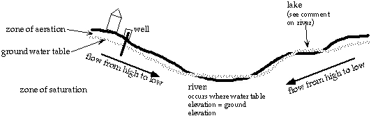
Groundwater table mimics topography, but is more subdued.
Just like water flows downhill on the surface, groundwater flows downhill.
When a well is being actively pumped, a "cone of depression" develops around it. If the well is pumped dry, it takes a long time for it to reestablish itself.

Rivers, streams, lakes, and other bodies of water are at the same level as the groundwater table. The groundwater table must be high in order for these bodies of water to be at the surface (and not dried up).
Aquifers
Confined aquifer
A confined aquifer is a layer of permeable and porous rock (an aquifer) that is between two aquicludes, or impermeable layers. This confined aquifer may build up pressure if it has water stored higher than the regional groundwater table, much like a water tower. This pressure can cause springs and wells that are dug to flow on their own. These are called Artesian springs and wells.
One way to get an Artesian spring is on a fault surface, essentially where there is a crack in the ground. This surface can be porous and permeable and therefore "leak," forming an Artesian spring.
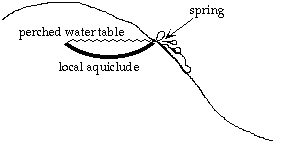
The regional water table, incidentally, is defined in the unconfined aquifer (see figure for illustration of definitions).

It is possible to have a local lens-shaped aquiclude higher than the regional water table. This is called a "perched" water table. These are common in Michigan because of its glacial history. All the tills left by glacial activity are a good source of clays, which prevent water flow and are impermeable. These tills become aquicludes. The outwash material made of sands and gravels are more porous and permeable and therefore become aquifers. The layering of till and outwash can produce Artesian springs.
Practical issues to consider
Want to understand groundwater because
- want to make sure home septic system does not pollute drinking water
- prevent industry and landfill waste from polluting drinking water
- specifically do not want to pollute a zone of recharge (where water is
entering the aquifer)
- for homes near a coast, want to regulate pumping, because overpumping the fresh water can cause salt water to invade the aquifer ("salt water incursion").
The Ogallala
The Ogallala aquifer is a large aquifer in the mid-US which runs in front of the Rockies. About 1/5 of US crops use water from the Ogallala aquifer. Over-pumping the Ogallala has caused large drops in the water table. This is an important issue since so much of the most arid part of the country relies on this water.
Back to GS 201 homepage