Projects
Remote Sensing & GIS

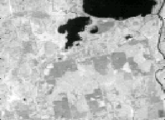
The picture at the top of the page is a Normalized Difference Vegetation
Index image that I created from Landsat TM data. Roughly speaking,
the image depicts
the amount of "greenness" or healthy vegetation: Increasing shades of
gray from black to white corresponds to an increasing amount of "greenness"
respectively.
Follow this link to learn more about this
project and to see numerous more images.
One can use GIS/Remote Sensing software to investigate things like how surface
topography may influence spatial patterns of land cover.
Follow this like to see a "proof of concept"
case study example of the San Diego area using a specific software.
The Aral Sea has been "shrinking" during the latter half of this century.
Follow this link to see some "proof of concept" examples of using
map algebra to create change detection maps for the Aral Sea.
I was fortunate to be a part of a space-borne lidar system
design team project called "VECTOR" in 1997.
As a team member, I communicated and
worked effectively, aiding specifically in the research of the optics for the
cost effective and compact satellite design. The overall project is no longer
viewable online but you can see some of my slides regarding the optics
here.
An individual project I undertook in 1997 was to examine and experiment
with the
integration of aspects of a spatially dynamic buffer for riparian zones using
various GIS platforms. Unfortunately, I was unable to obtain DEM data in
time so the products depicted
here are less functional than intended, but
the concept is a good idea. The coverage data I used during this project was
obtained from the
Alaska National Park Service Geospatial Clearinghouse.
This page is currently under construction, as I am trying to put more
examples of my work and other projects in online form. Please feel free
to email me at
sjbrines@umich.edu
with questions concerning these or current projects...
Or use my web Response Form. Thanks!
