Beach Closures in Oakland County, Michigan:  Using GIS as an Investigative Tool

Jeanine Chura McCloskey


click on picture above to link to Oakland County's website

Introduction:

The state of Michigan has always been a prime recreational area during the summer months for tourists as well as permanent residents. Michigan, the "Great Lakes State," has prided itself on having some of the best lakes, both from a boating and bathing perspective, among all fifty states. Oakland County, part of the Detroit "metropolitan area" is no exception. The county is one of the most affluent in the country and contains over 200 bathing beaches. Unfortunately, over the last few years beach closings have been on the rise. The Environmental Protection Agency stated that state and local governments across the country issued 4000 beach closings in 1995 alone ("Beach Watch" 1) and, "The number of beach closures reported every year is also on the rise (1).
EPA's Beach Watch:
The problem became so much of a concern that the Environmental Protection Agency initiated the BEACH Program (Beaches Environmental Assessment, Closure, and Health) in 1997 with the goal of improving U.S. recreational waters and reducing the risk of disease to those who frequent the beaches. Among the official goals of this Beach Watch Program were: strengthening standards, improving beach programs at local governments, better communication with the public, and providing funding for research to improve detection methods and further protect public health. The BEACH Program lead to the passage of the BEACH Act (Beaches Environmental Assessment and Coastal Health Act) on October 10, 2000 ("Beach Act" 2). This Act amended the Clean Water Act and contains three "significant" provisions including: requiring states with coastal waters to implement standards (new or revised) for pathogens and their indicators by April 10, 2004, requiring the EPA to conduct studies and publish new water quality guidance for pathogens effecting human health by 2005, and allowing the EPA to award grants to states in order for them to implement beach and risk communication programs regarding recreational water quality (2).
Causes of Beach Closures:

●Rainfall: sewer overflows, storm water runoff, septic systems

●Boating wastes

●Location:  land-use, sewers, etc

●Number of users

●Animal wastes


Oakland County's Procedures:

Oakland County samples roughly 60 of their 286 beaches yearly and the others are on a five-year rotation.  Beaches sampled each year include government owned properties, camps, and commercial beaches (or “pay to enter”) properties.  However, any beach that has a history of high bacteria levels, whether or not it is government, commercial, or a camp, is also sampled each year.  Three 100ml samples of beach water, at waist level, are taken at each assigned beach each week.  The samples are then analyzed for the presence of E-coli.  Initially, if any one of the samples is greater than 300 E-Coli per 100ml the beach must be closed, however, after one month of sampling a rolling geometric mean is calculated and the limit is 130 E-Coli per 100ml.  The testing method is done on-site in the County’s laboratory and results are obtained after 18 hours (“Oakland County”).  Last summer I had the privilege of interning with the County and worked on the beach program as one of several other responsibilities.  The interns were responsible for sampling their assigned beaches for the amount of E-coli per 100ml at least once per week and determining whether or not the beach should remain open from the results of the tests.  I had noticed throughout the summer that almost every time it rained it seemed as if a great deal of beaches would be closed the next day.  Rainfall, in fact, has been proven to be a beach closure predictor for some beaches although its importance in terms of a determinant have been debated.  In a study done in the UK, researchers claim that rainfall is only a minimal component stating that sunshine, wind, and catchment sources were much stronger predictors (Crowther et al. 4029).  Other studies, however, claim that rainfall is a major component.  Studies done in Australia indicated a “linear relationship between visual indicators and bacterial density . . . and rainfall alone as a predictor is equivalent to or better than visual assessment” (Armstrong et al. 249).  Many beaches in Australia actually use rainfall determined from gauge stations throughout the country to prepare daily beach reports/closures (249). 
Hypothesis:
In this study I compare rainfall and beach closings in Oakland County, for 1998 and 2001, using GIS as the main investigative tool.  Correlations between the two variables is investigated in order to see if this simplified analysis could be utilized for beach closure decision making.  GIS could prove to be an invaluable resource in terms of presenting the spatial relationships between rainfall and rain gauge sites to beach locations.    This data could vastly improve detection methods and perhaps save a great deal of funding money.  Results may aid in predictive modeling for E-coli in recreational waters since the present testing methods require at least 18 hours in order to obtain results.  If rainfall alone can be used as a predictor of beach closure in the county there is the potential to save money spent on beach programs/sampling, protect individuals from health threats due to "dirty" water, and avoid time delays waiting for results.


Data:                        

Beach closing information including the beach name, location, and E-coli geometric means were provided by the Oakland County Health Division- Environmental Health Department in tabular format and entered into Excel worksheets.  Beach locations and Oakland County boundary line themes were provided in digital format (ArcView 3.2).  Rainfall data was obtained from the Oakland County Drain Commissioner’s office.  Tables with rainfall from the county’s rain gauge stations and the recorded rainfall at the stations for June and July of 1998 and 2001 was also provided, both in tabular format.  Again, Excel was used in order to convert the tabular data into digital, database format.  Oakland County street and highway theme layers were obtained from the University of Michigan Map Library and were already in ArcView 3.2.


1998 Beach Closures

2001 Beach Closures

Methods:                                        

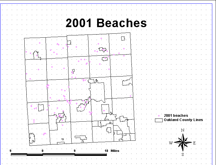
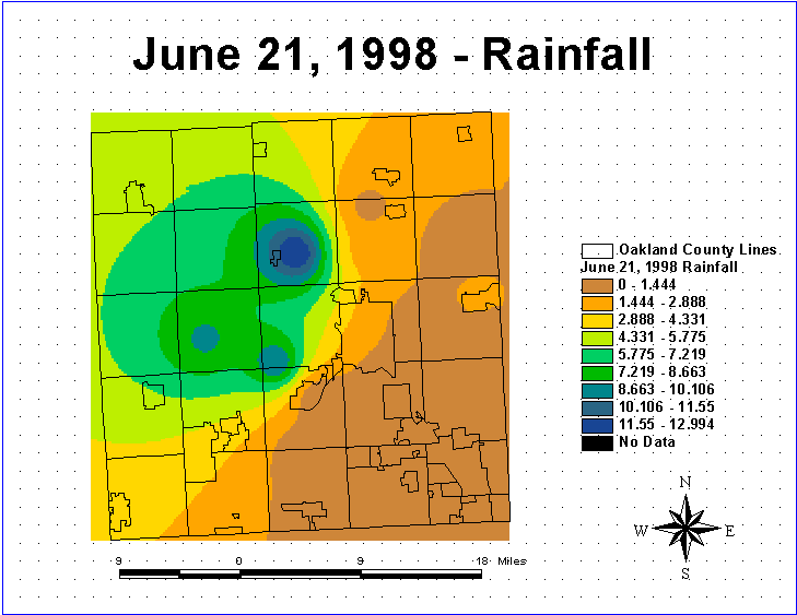
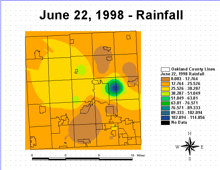
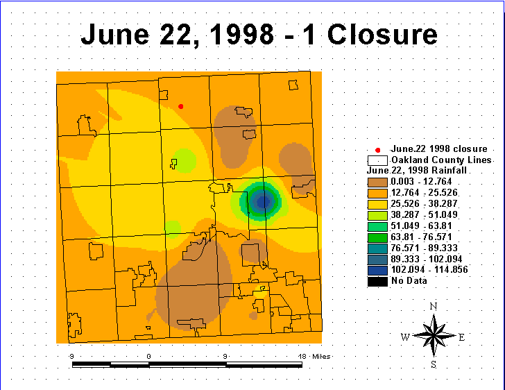
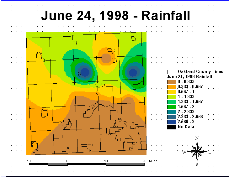
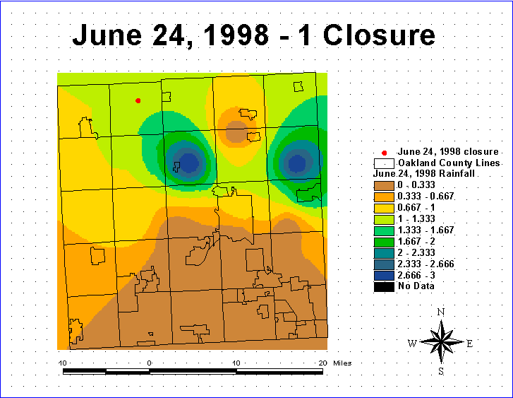
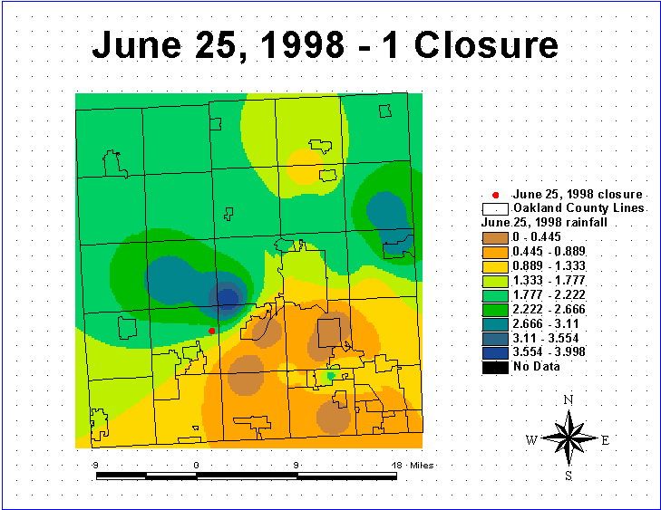
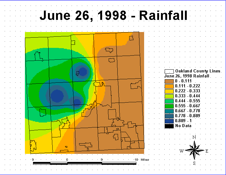
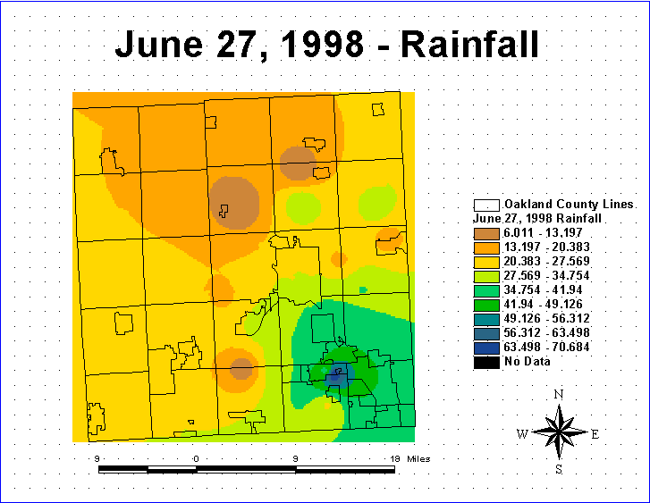
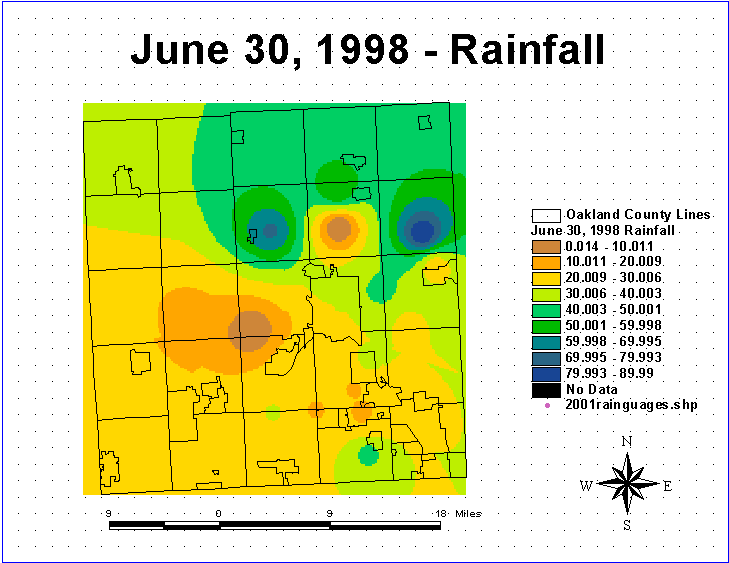
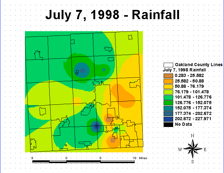
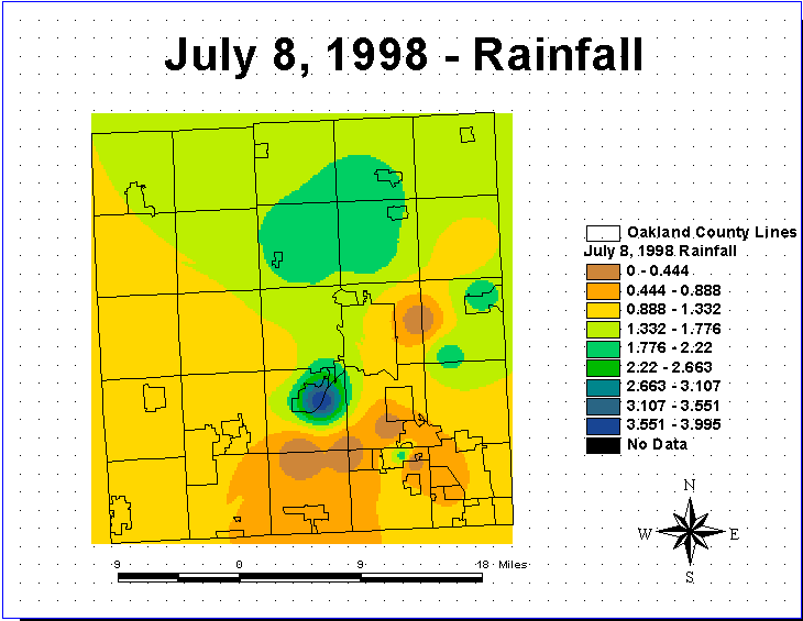
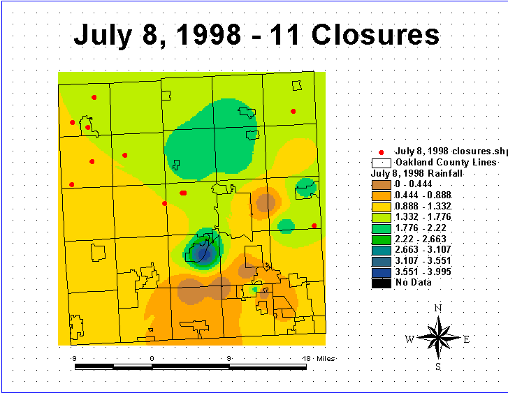
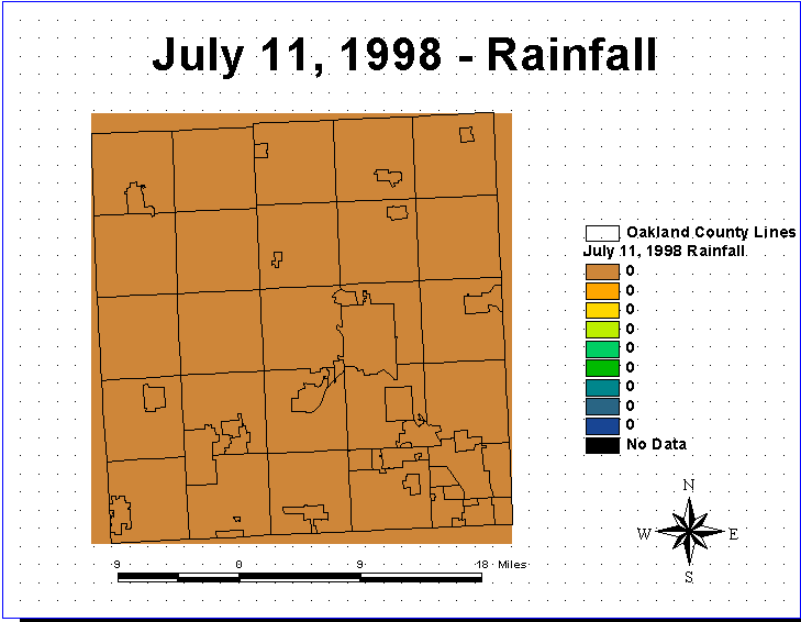
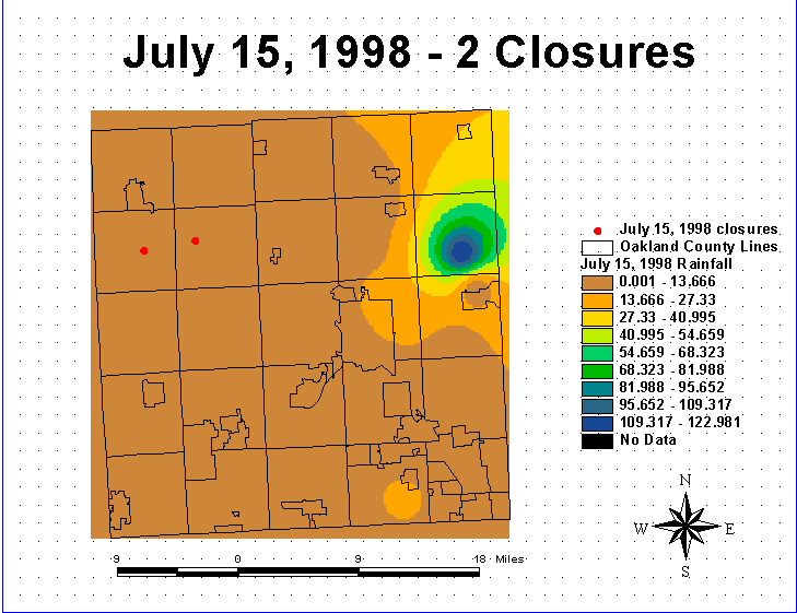
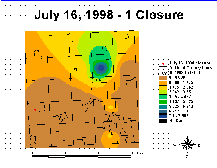
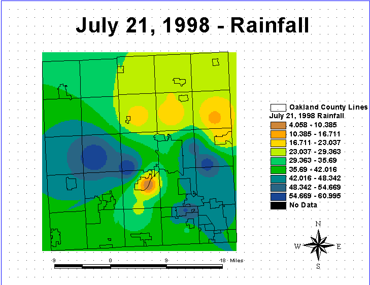
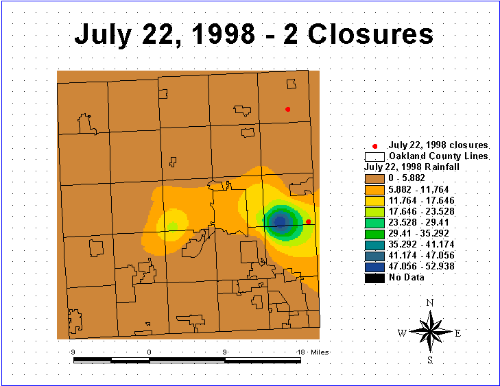
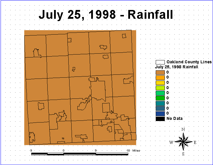
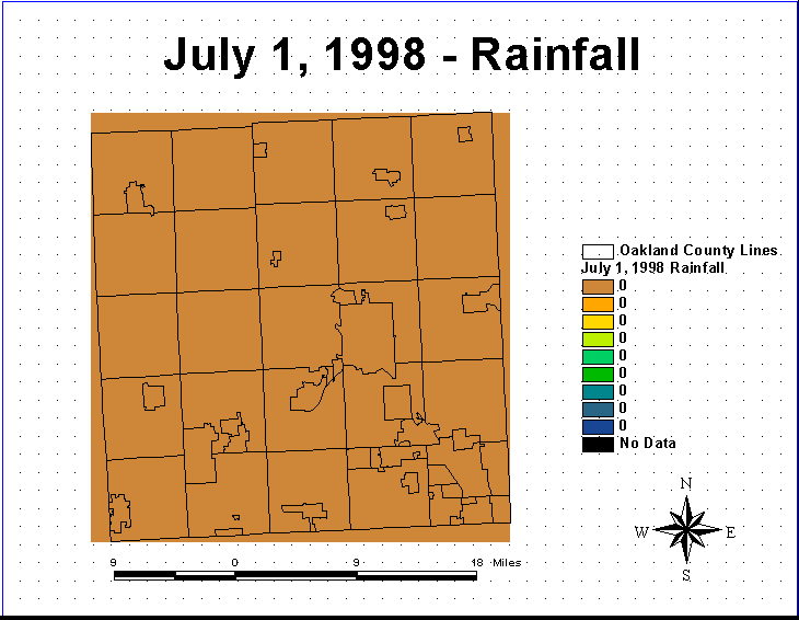
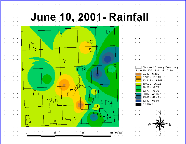
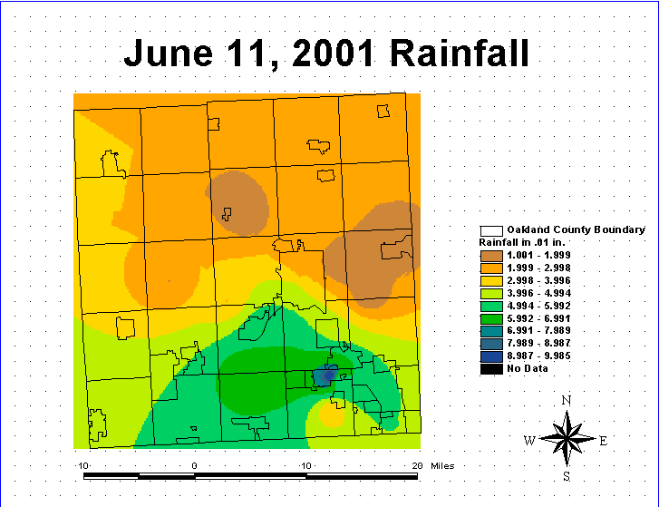
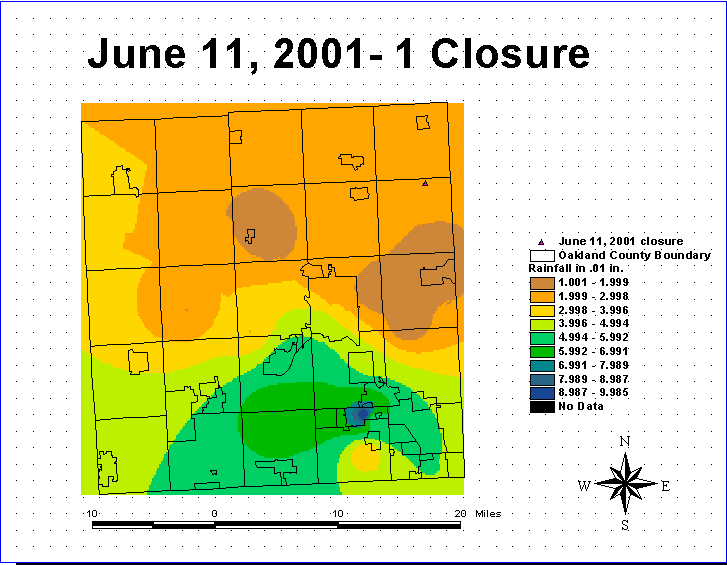
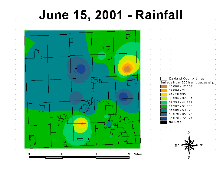
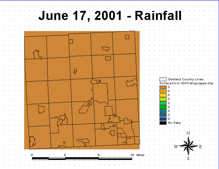
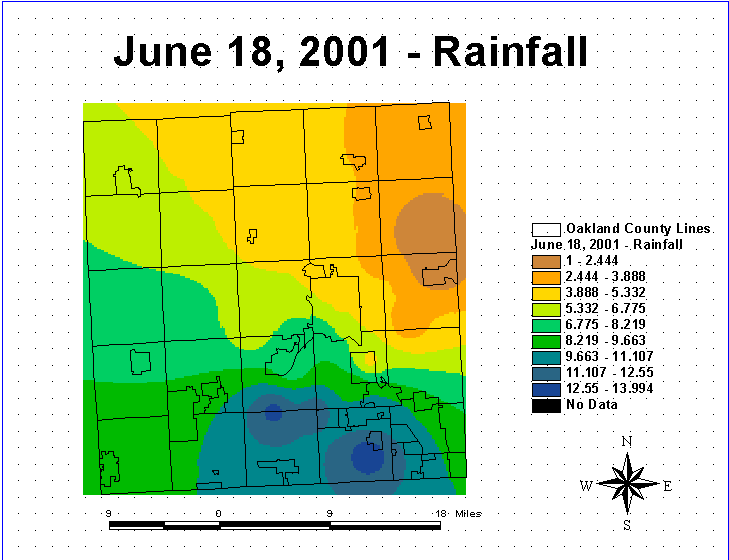
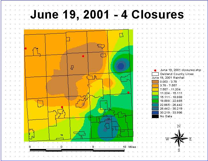
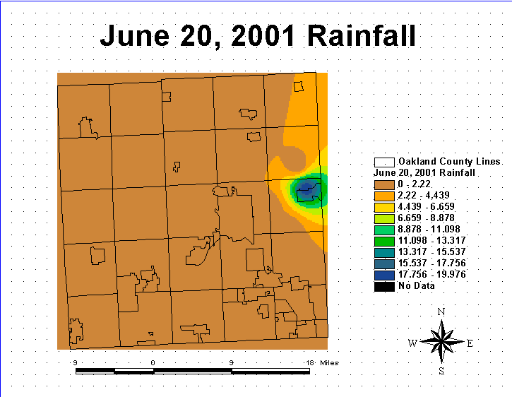
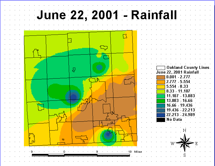
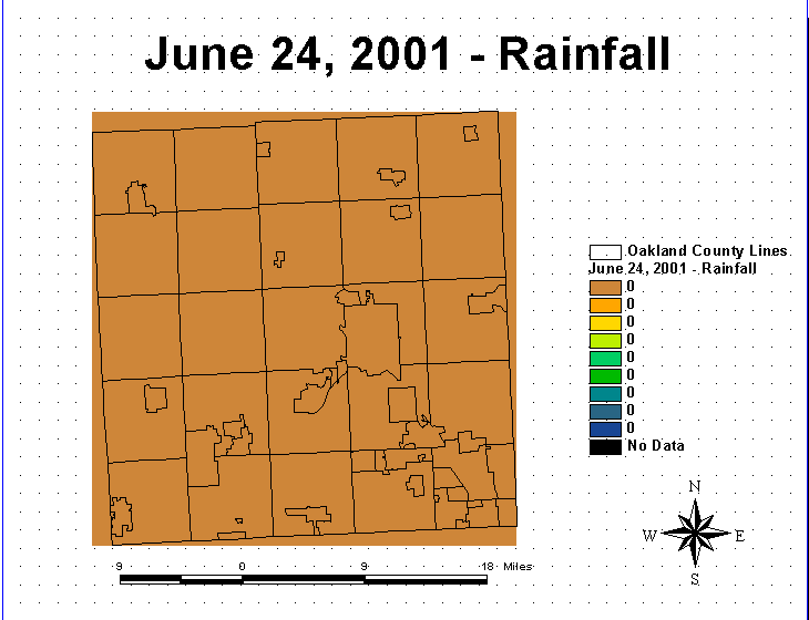
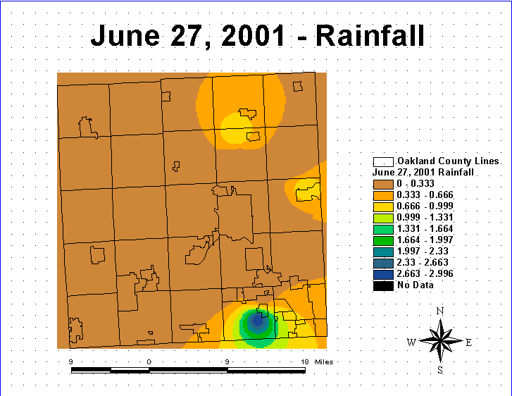
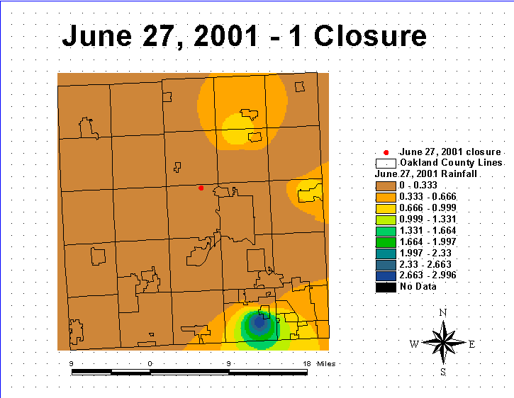
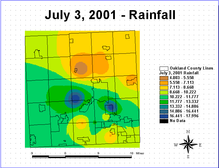
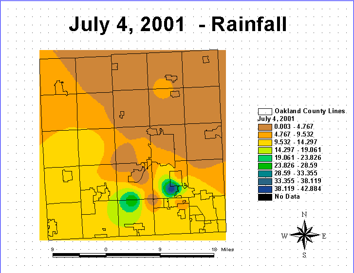
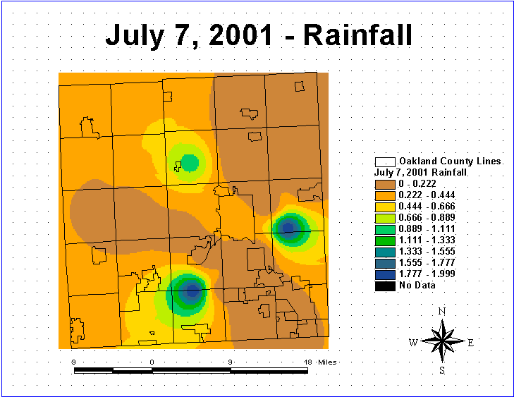
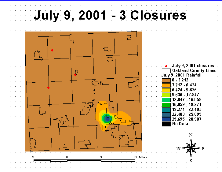
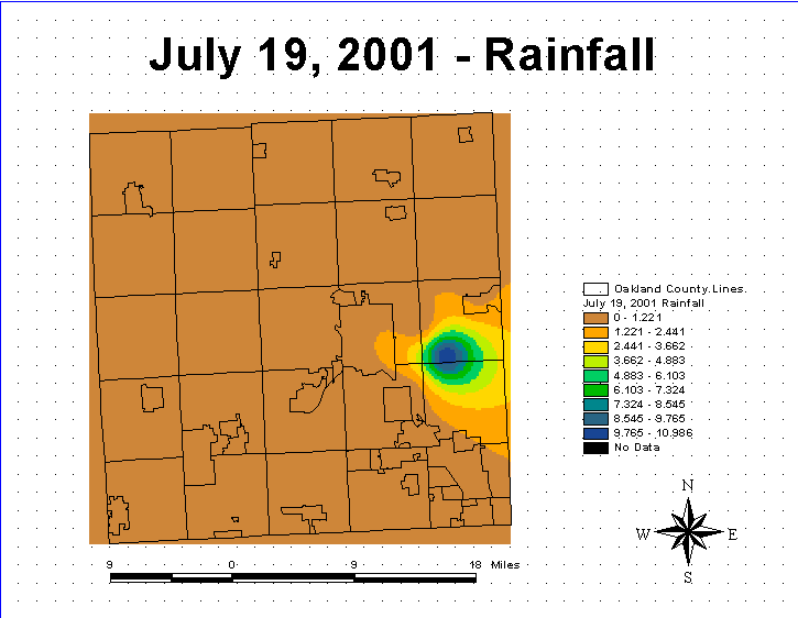
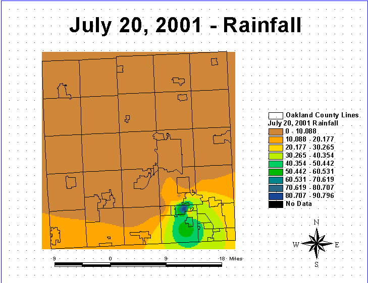
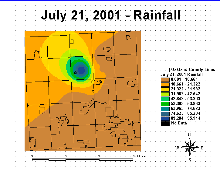
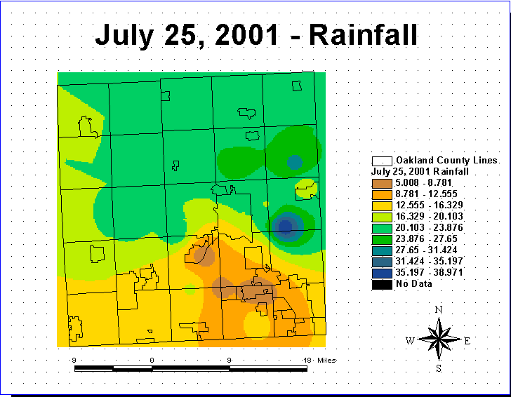
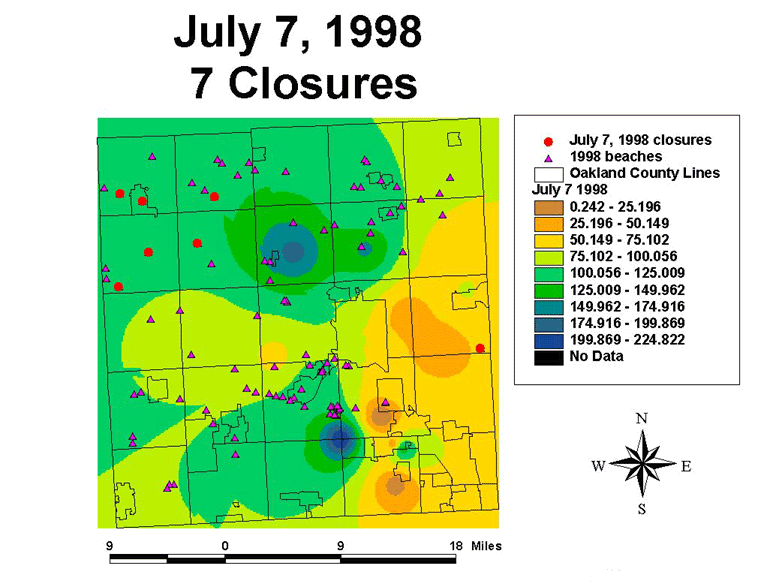
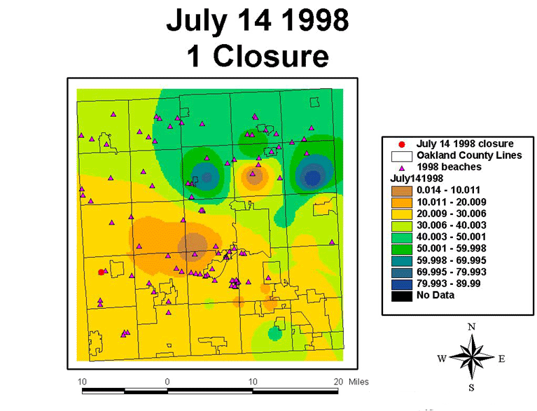
The initial portion of the study was determining the “beach closure days” for June and July of 1998 and 2001.  Once this was determined the beaches closed were added to a database table.  The rain gauge locations had to be geo-coded as U.S. street addresses using the Oakland County street layers from the Map Library at UM as a reference theme.  Eighteen rain gauge stations were located out of the twenty-one present.  The rain gauge locations were then saved as a new theme or .shp file.  Once the gauge stations were defined, the rainfall at each station was also incorporated into the database tables for a portion of the month of June (when sampling began) through the end of July in 1998 and 2001.  The Excel tables were then transferred into ArcView 3.2 as .dbf files.  ArcView 3.2 spatial analysis extension was then used which allowed me to determine the rainfall at each closed beach.  The rainfall at the closed beaches on the day of the closure was then determined and incorporated into the tables in Excel.  Layouts were produced for each day (June-July) showing the spatial analysis determined rainfall distribution for the County and the closed beaches.  Graphs using Excel were made to show the rainfall amounts in hundredths of inches and bacteria levels in #E-coli per 100ml.

    Hardware:  Windows based machine

    Software:  ArcView 3.2 was used to analyze the rainfall and beach closure data.  Microsoft Excel was     used to create the data tables of the rainfall and beach closing information.  Adobe photoshop was used to    format all layouts for web use.  Moviegear was utilized to create the animations.


Results:          

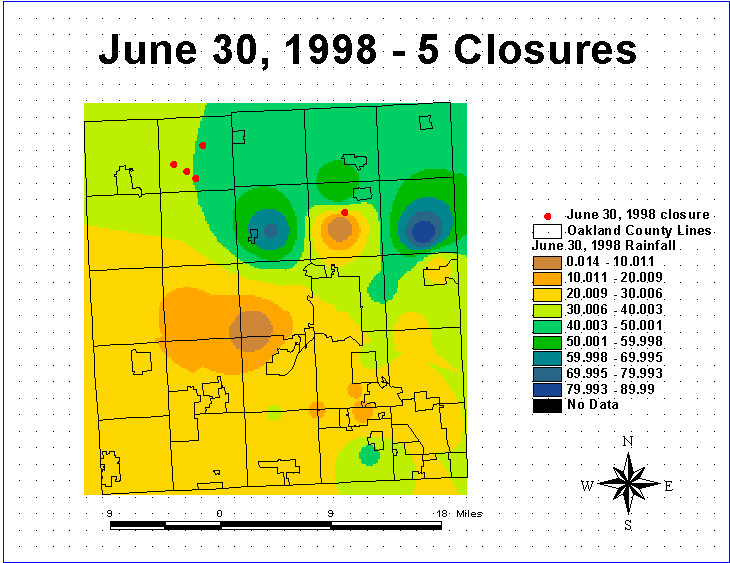
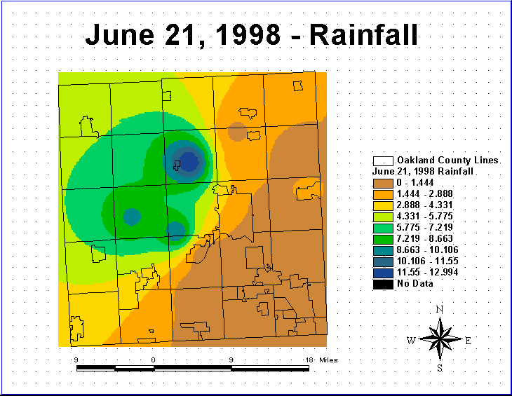
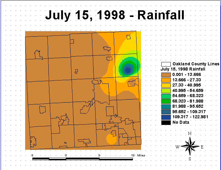
June 1998 Still Frames of Rainfall and Beach Closures:

June-21,-1998-rain.gif (18798 bytes)June-22-98-rain.gif (17182 bytes)June-22-98-closure.gif (17847 bytes)JUne-23-98rain.gif (12850 bytes)JUne-24-98rain.gif (18227 bytes)June24-98closure.gif (18363 bytes)JUne25-98rain.gif (18618 bytes)June25-98closure.gif (19022 bytes)June-16-98rain.gif (19086 bytes)June-27-98rain.gif (17592 bytes)June-28-98rain.gif (12718 bytes)June-29-98rain.gif (12886 bytes)June-29-98closure.gif (12798 bytes)June-30-98rain.gif (18703 bytes)

June-30-98closures.gif (19025 bytes)

June 1998 Animation:

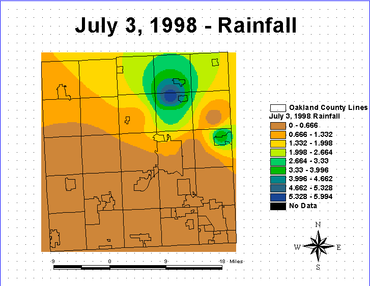
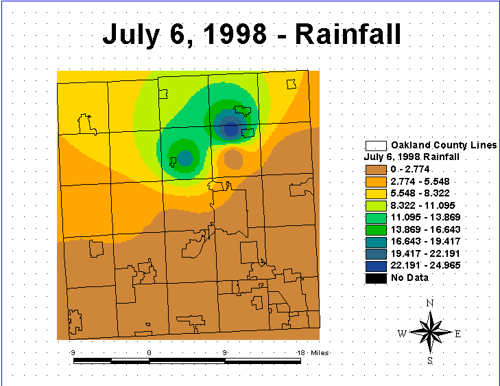
July 1998 Still Frames of Rainfall and Beach Closures:

July-1-98rain.gif (12787 bytes)July-1-98closures.gif (12408 bytes)July-2-98rain.gif (12789 bytes)July-3-98rain.gif (17201 bytes)July-4-98rain.gif (19161 bytes)July-5-98rain.gif (12547 bytes)July-6-98rain.gif (17496 bytes)July-6-98closures.gif (17713 bytes)July-7-98rain.gif (18893 bytes)July-7-98clo.gif (19276 bytes)July-8-98rain.gif (17992 bytes)July-8-98clo.gif (17821 bytes)July-9-98rain.gif (13025 bytes)July-10-98rain.gif (13104 bytes)

July-11-98rain.gif (13199 bytes)July-12-98rain.gif (13069 bytes)July-13-98rain.gif (13125 bytes)July-13-98clo.gif (13236 bytes)July-14-98rain.gif (13110 bytes)July-14-98clo.gif (13215 bytes)July-15-98rain.gif (16699 bytes)

July-15-98clo.gif (16769 bytes)July-16-98rain.gif (17518 bytes)July-16-98clo.gif (17328 bytes)July-17-98rain.gif (12890 bytes)July-18-98rain.gif (13037 bytes)July-19-98rain.gif (17572 bytes)July-20-98rain.gif (13085 bytes)

July-20-98clo.gif (13217 bytes)July-21-98rain.gif (19553 bytes)JUly-22-98rain.gif (16088 bytes)July-22-98clo.gif (16366 bytes)July-23-98rain.gif (13107 bytes)July-23-98clo.gif (13184 bytes)July-24-98rain.gif (13027 bytes)

July-25-98rain.gif (13106 bytes)July-26-98rain.gif (12714 bytes)July-27-98rain.gif (13069 bytes)July-27-98clo.gif (13100 bytes)July-28-98rain.gif (13054 bytes)July-28-98clo.gif (13113 bytes)July-29-98rain.gif (13087 bytes)

July-29-98clo.gif (13193 bytes)July-30-98rain.gif (13114 bytes)July-31-98rain.gif (13114 bytes)

July 1998 Animation:


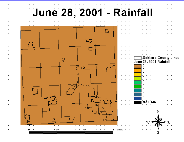
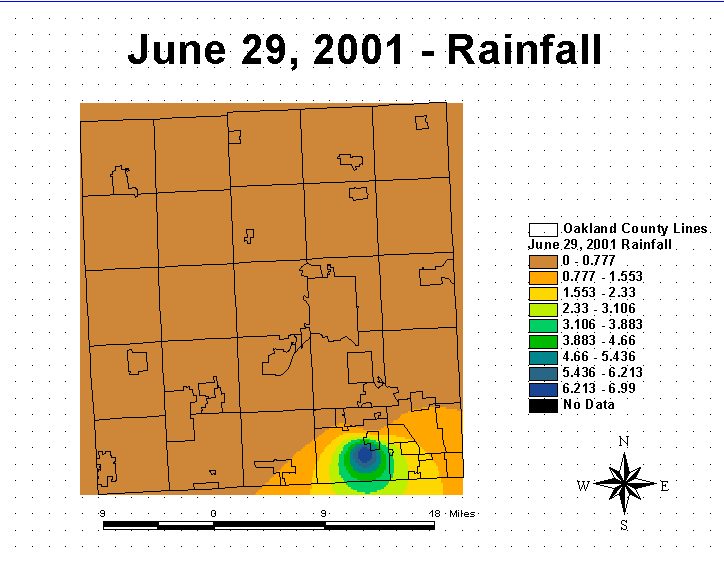
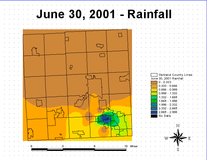
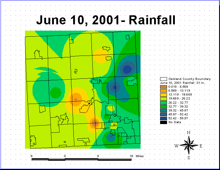
June 2001 Still Frames of Rainfall and Beach Closures:

June 10, 2001.gif (18681 bytes)June-11,-2001-rainfall.gif (16459 bytes)june-11,-2001-1-closure.gif (16776 bytes)June-12,-2001-rainfall.gif (12401 bytes)June-13,-2001-rainfall.gif (12643 bytes)June-14-2001-RAinfall.gif (12677 bytes)June-15,-2001---Rainfall.gif (16866 bytes)June-16,-2001---Rainfall.gif (12826 bytes)June-17,-2001---Rainfall.gif (12085 bytes)June-18,-2001---Rainfall.gif (17482 bytes)JUne-19,-2001---Rainfall.gif (19299 bytes)JUne-14,-2001---closures.gif (18802 bytes)June-20,-2001-Rainfall.gif (14942 bytes)JUne-20,-2001---2-closures.gif (14592 bytes)

June-21,-2001-Rainfall.gif (19040 bytes)June-22,-2001-Rainfall.gif (18880 bytes)June-23,-2001---Rainfall.gif (17046 bytes)June-24,-2001-Rainfall.gif (12868 bytes)June-25,-2001---Rainfall.gif (12742 bytes)June-25,-2001---closure.gif (12598 bytes)June-26,-2001---Rainfall.gif (12743 bytes)

June-26,-2001---closure.gif (13117 bytes)June-27,-2001---Rainfall.gif (15790 bytes)June-27,-2001-closure.gif (15904 bytes)June-28,-2001---Rainfall.gif (12690 bytes)June-29,-2001-Rainfall.gif (13734 bytes)June-30,-2001-rainfall.gif (14929 bytes)


June 2001 Animation:


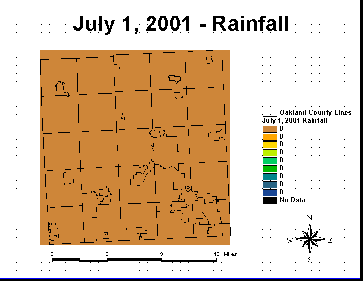
July 2001 Still Frames of Rainfall and Beach Closures:

July-1,-2001---Rainfall.gif (12297 bytes)July-2,-2001---Rainfall.gif (12351 bytes)July-3,-2001---Rainfall.gif (18100 bytes)July-4,-2001---Rainfall.gif (16684 bytes)July-5,-2001---Rainfall.gif (12819 bytes)July-6,-2001-Rainfall.gif (12685 bytes)July-7-01-Rainfall.gif (18335 bytes)

July-8-2001-Rainfall.gif (12881 bytes)July-9,-2001-Rainfall.gif (14709 bytes)July-9,-2001-closures.gif (14981 bytes)July-10,-2001-Rainfall.gif (16221 bytes)July-11,-2001-Rainfall.gif (12905 bytes)July-12,-2001-Rainfall.gif (11453 bytes)July-13-2001-closures.gif (12401 bytes)

July-14,-2001-rainfall.gif (12381 bytes)July-15,-2001-rainfall.gif (12450 bytes)July-16,-2001-rainfall.gif (12668 bytes)July-17,-2001-rain.gif (17610 bytes)July-17-2001-closures.gif (16929 bytes)July-18,-2001-rainfall.gif (17333 bytes)July-19,-2001-rain.gif (14025 bytes)

July-20,-2001-Rainfall.gif (15797 bytes)July-21,-2001rain-new.gif (16736 bytes)JUly-22,-2001-rainfall.gif (15748 bytes)July-23,-2001-rainfall.gif (17041 bytes)July-24,-2001rain.gif (12495 bytes)July25,-2001-rainfall.gif (17626 bytes)July252001-closure.gif (17177 bytes)


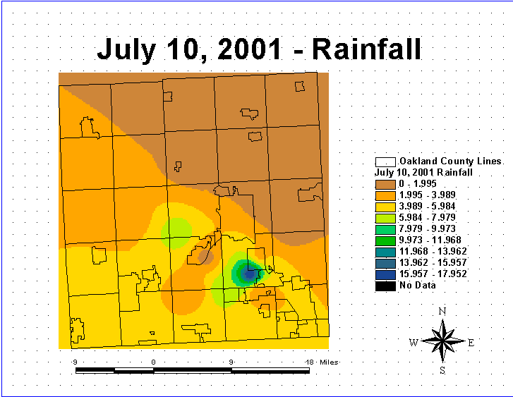
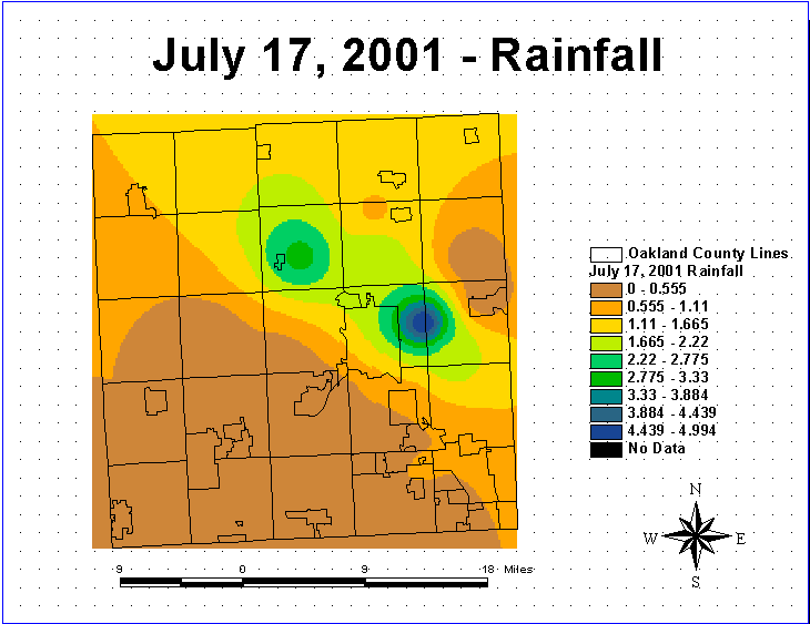
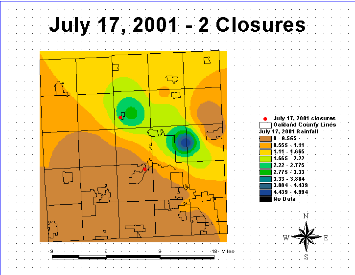
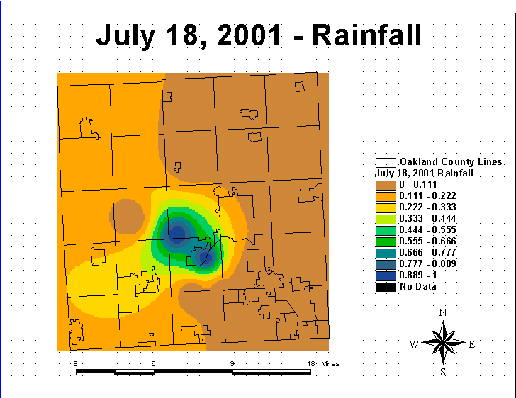
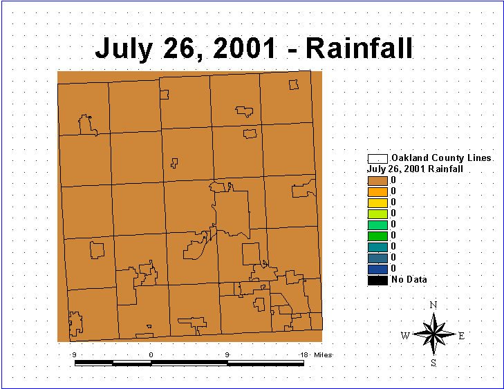
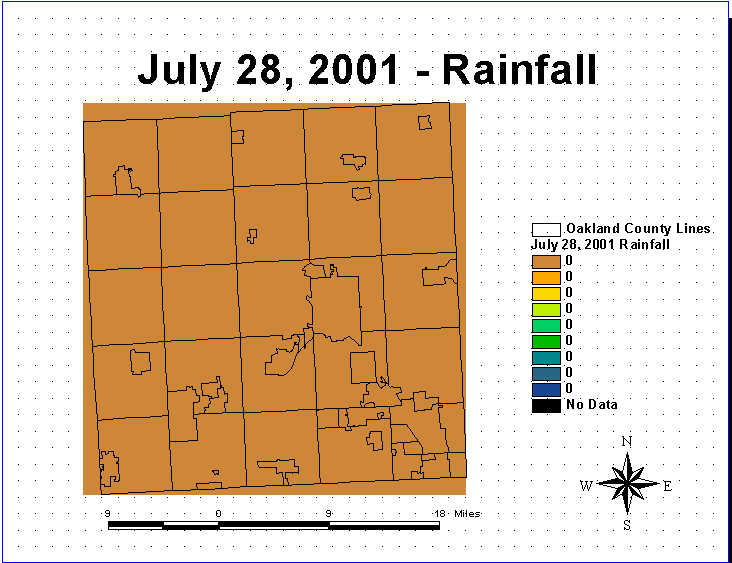
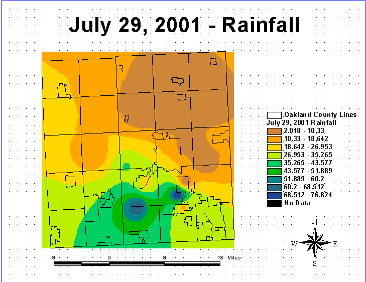
July 2001 Animation:

Conclusions:

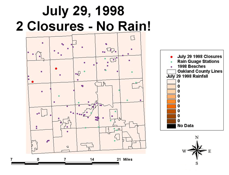
1998:  In 1998 there were 49 total beach closures in Oakland County.  June had 9 closures with one beach closure day receiving zero inches of rain.  July had 40 beach closures with sixteen closure days receiving zero inches of rain.  Total average rainfall for June was 1.7 inches.  July total average rainfall recorded at the gauge stations was 1.8 inches.

2001:  In 2001 there were a total of 29 beaches closed.  Twelve beaches were closed in June with 4 closure days occurring on zero inch rainfall days.  July had 17 closures with 10 closure days occurring on days with zero inches of rain.  The total average rainfall for June and July was 2.6 inches and .90 inches, respectively.

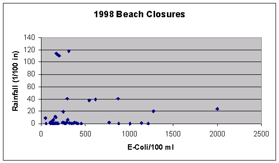
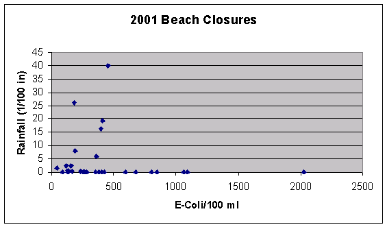
Graphs showing E-Coli/100 ml. versus rainfall (1/100 in.) for the 1998 and 2001 closed beaches are portrayed  below.  It is evident that there is not a direct correlation between rainfall and beach closures.  In fact, the graphs suggest that shorter amounts of rainfall may be more indicative of beach closures.  This may make sense because during short rain storms bacteria may just be washed into the beach concentrating near the shore, where as during long storms the bacteria has a chance to disperse further into the lake and not concentrate near the shore and the beach causing the E.Coli levels to diminish.  However, most beaches were closed on days that it had rained.  Thirty-two of the 49 beaches closed in 1998 and 15 of the 29 beaches closed in 2001 were on "rainy" days.  Also, if it had not rained on the beach closure day, most beaches recorded rain measurements on the day prior to the closure.  For example, out of the 49 beaches closed in 1998 only 10 of these were closed on days recording 0 inches of rain on both the day prior to the closure and the beach closure day itself.  In 2001 there were 5 beaches out of 29 closed that did not receive rain on both the day prior and the day of the closure.  This time factor could make a difference because no data was available on the time the beach was sampled, or the time of the rain gauge measurement.  It must be stressed that this study only took into account rainfall and many other factors including beach location, proximity to sewers and storm drains, amount of use, and animal activity also have the potential to effect bacterial levels and beach closure.


Future Goals:

This study is a preliminary first step of many that need to be implemented to study beach closures in Oakland County.  An attempt was made to correlate the amount of rainfall with beach closures, but it is evident that many other factors need to be incorporated into a closure model, although it is safe to assume that rain does play a role in beach closures.  Other factors such as proximity to septic systems and storm water drains, land use patterns (agricultural vs. industrial), and animal activity could also be implemented into this study to provide further input into the exact causes of closures.  It is apparent that most beaches are closed either on the day of significant rainfall, or the day after, so some sort of time factor should also be included.  Since only a minimal number of closures occurred on days when it did not rain, or one day after a significant rain event, one can conclude that it is safer to avoid swimming for at least one day after the rain event in order to allow bacterial levels to subside.

 
References:

Environmental Protection Agency.  “Beach Act.”  www.epa.gov/OST/beaches .   

25jul2001:  1-16

Environmental Protection Agency.  “Beach Watch, Frequently Asked Questions.”

            www.epa.gov/OST/beaches/faq.html .  Access 25 Feb 2002:  1-6.

Crowther, J., Kay, D., and M. Wyer.  “Relationships Between Microbial Water

            Quality and Environmental Conditions.”  Water Research.  V35n17 (Feb2001):

            4029-2038.

Armstrong, I., Higham, S., Hudson, G. and T. Colley.  “The Beachwatch Pollution

Monitoring Programme:  Changing Priorities to Recognize Changed

Circumstances.”  Marine Pollution Bulletin.  V33n7-12:  249-259.


.