| I |
|
|
|
|
Environmental Justice refers to those cultural norms,
values, rules, regulations, behaviors, policies and decisions that support
sustainable communities where people can live with confidence that their
environment is safe, nurturing and productive. |
|
|
Bunyan Bryant
|
|
|
INTRODUCTION: The state of Alabama
is no stranger to major environmental concerns, especially over the past
several decades. Sumter County, for example, houses one of the largest
hazardous-waste treatment, disposal and storage facilities in the United
States. It has been cited, fined and temporarily closed over the years
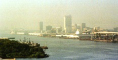
for not operating within regulation. Further south, in the southwest corner
of the state, is Mobile County, bordered by the state of Mississippi on
the west, Washington County on the north, Baldwin County and Mobile Bay
on the east and the Gulf of Mexico on the south. Because of its location,
this port community has been able to attract large numbers of business
and industry, but not without triggering air, water and groundlevel pollution.
This Environmental Justice mapping project will take a
closer look at the environmental concerns facing Mobile County, focusing
on the small, mostly African-American community of AfricaTown USA. Environmental
Justice concerns arise when there is evidence of citizens being disproportionately
affected by their environment. In most cases, these citizens are predominately
minority, poor and have completed lower levels of education than their
surrounding neighbors. AfricaTown is unique because it puts to rest arguments
centering around which came first -- the mostly minority, poor population
or the environmental hazards. AfricaTown was founded in 1868 and its inhabitants
are believed to be the last Africans to travel by slaveship to the United
States. In fact, descendents of those West Africans still live in that
community. |
|
|
|
|
|
|
|
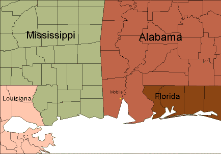 |
This is a general map showing exactly where the state of Alabama and
Mobile County are located in proximity to surrounding states. |
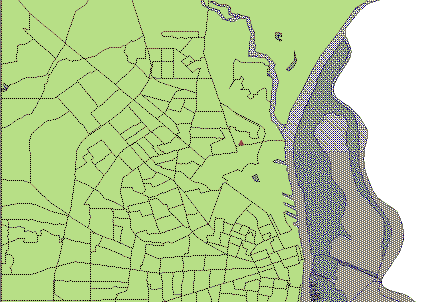 |
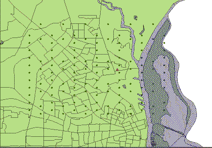
This map zooms in on Mobile County, focusing on the eastern section
closest to Mobile Bay. AfricaTown is marked with a brown triangle. |
 |
A grid was laid over a map in LandView III and the number of EPA features
were calculated to make this map. The features used in this calculation
were: Air Facilities; Hazardous Waste sites; Superfund Non-National Priority
List (NPL) sites; Superfund NPL sites; Toxic Release Inventory (TRI) sites;
and Wastewater Discharge Facilities.
Using the measurement, approximately 1 mile = 1 inch, a grid was printed
out and manually marked with the numerical weights calculated, per square,
by LandView III. Each square equaled the number of EPA features inside.
The total number of EPA features are symbolized by a point in each polygon.
This information was placed on an Excel spreadsheet with the center of
each square's longitude and latitutde included. |
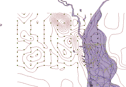 |
This map shows how the points are connected, based on weight value
(the number of EPA features it represents), creating a contour. |
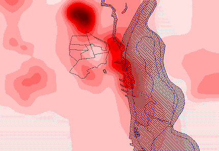 |
This map also displays the connected points, creating a contour. But
now filled in, you can see a range of colors. The darker the red, the more
EPA features are included in that particular area. Note the proximity of
the reds to AfricaTown. |
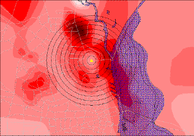 |
This map includes a "buffer" of 10 concentric circles of 1/4 mile each.
The rings grow in distance from one of AfricaTown's landmarks, Union Missionary
Baptist Church. |
|
The above maps were derived from the mapping
software Streets 5.0; the Geographical Information Systems (GIS) software
ArcView 3.2 and LandView III, made available by the U.S. Environmental
Protection Agency (EPA). LandView III includes recent data from the EPA,
the Bureau of the Census, the U.S. Geological Survey and the National Oceanic
and Atmospheric Administration. |
|
|
|
|
|
CONCLUSION: Based on the mapping analysis
presented and Census date collected, the evidence presented in these maps
shows most of the Mobile County residents living closest to Mobile Bay,
which is adjacent to AfricaTown, are African Americans. The data also reveals,
most of the environmental waste and major hazards travel along that waterway,
which is in very close proximity to AfricaTown.
Many Environmental Justice reports and studies have revealed
conflicting results as to whether communities, especially in the southern
region of the U.S., are directly targeted with environmental waste because
of its large, poor, minority population. Many question if large corporations
target these areas because of its demographics, or if the so-called targeted
population moved to a given area, after the hazards were already present.
In the case of AfricaTown, there is little argument over who was first.
AfricaTown was founded over 130 years ago, with descendents of the slaves
who traveled from West Africa still residing near the Bay.
|
|
|
I |