1"=100' Aerial Photograph of Oakbrook Villas, City
of Ann Arbor
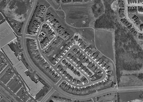
Rough Estimate of Impervious Values:
Implications for Water Quality in Malletts Creekshed
It is often difficult
for planners to generate accurate imperviousness values for highly urbanized
watersheds. Often, these values are most easily calculated by employing
Digital Elevation Models that show how water moves across the topography.
However, in a small, urban watershed, such as Malletts, this will not produce
realistic results. By under laying the below digital orthophotograph
and individually digitizing areas, using Arcview GIS, for a sample of rooftops,
driveways, pathways, and sidewalks (excluding roads), we found the following
breakdowns and imperviousness value for the 2.2 acre block:
| Type | Avg. Area (Sq.Ft.) | Area in Acres | % Impervious |
| Sidewalks | 125.14 | .05 | 2.34 |
| Roofs | 2077.05 | .86 | 38.76 |
| Paths | 46.80 | .02 | 0.87 |
| Drives | 346.89 | .14 | 6.47 |
| TOTAL | 2595.88 | 1.07 | 48.45 |
A general rule of thumb used by planners:
if more than 10% of the creekshed is impervious surfaces, the water quality
of the creek starts deteriorating. Since 40% of Malletts Creekshed
is residential, and assuming that all the residential communities are around
50% impervious, then the creekshed - just considering this land use type
- is already about 20% impervious.
1"=100' Aerial Photograph of Oakbrook Villas, City
of Ann Arbor