Michigan Conservation Districts and Farmland Preservation: An Analysis of Predictors of Farmland Vulnerability to Conversion and Variables Influencing District Activity
RESEARCH JOURNAL
GEOGRAPHY: SPATIAL ANALYSIS, THEORY AND PRACTICE
Professor Arlinghaus
Fall 1998
Joe E. Holtrop
Project Goal:
Determine why farmland and open space preservation is a low resource conservation priority for most Michigan conservation districts.
Project Objectives:
- Identify and spatially analyze variables that contribute to conservation district farmland and open space preservation activity
- Develop a comprehensive index of farmland vulnerability (threat of conversion to non-farm use)
Project Background
In the spring of 1998, I analyzed conservation district work plans for the 82 districts in Michigan to determine how much priority districts place on broad land use issues that indirectly, but ultimately impact natural resources. Specifically, I was concerned about the role (actual and perceived) of conservation districts in farmland and open space preservation.
Based on the narratives of these plans, which were written in late 1997, I categorized each district as either inactive (no reference to farmland protection or related land-use activities), moderately active (statutory land-use programs identified and/or concern expressed about farmland conversion), or proactive (specific activities identified to protect farmland) regarding farmland and open space protection. I found 52% of the districts to be inactive, 26% moderately active, and 22% proactive. When I compared these findings with the actual threat of farmland conversion described in 1994 by the Michigan Society of Planning Officials (MSPO), I found very little correlation between the two. Proactive districts were just as likely to be in counties with very little or no threat of farmland loss as they were to be in very threatened counties, and likewise for inactive districts.
One would expect the vulnerability of farmland to be an important predictor of conservation district farmland preservation activity; therefore, an accurate indicator of farmland vulnerability is critical. The MSPO index was based on the estimated market value of land and buildings and the change in population. Counties at greatest risk were identified as having average per acre farmland value greater than $1,500 and/or a population increase of at least 1,506 between 1980 and 1990. Concerned about how comprehensive this indicator of farmland threat was, I decided to attempt to develop an index that would include more variables. I also wanted to understand what other factors may be influencing the activities of conservation districts.
Project Tasks:
- Base Map and Data Base Preparation
- Obtained a base map of Michigan counties for use in developing a GIS.
- Using Atlas GIS, converted the following counties to districts:
- Berrien County – St. Joseph River CD in north 2/3 and Galien River CD in south 1/3
- Chippewa County and east half of Mackinac County – Chippewa CD
- Luce County and west half of Mackinac County – Luce-West Mackinac CD
- Crawford County and Roscommon County – Crawford-Roscommon CD
- Houghton County and Keweenaw County – Houghton-Keweenaw CD
- Livingston County – South Livingston CD in south half, Northwest Livingston CD in northwest ¼, and Fenton CD in northeast ¼
- Mason County and west half of Lake County – Mason-Lake CD
- Osceola County and east half of Lake County – Osceola-Lake CD
- Eaton County – Thornapple-Grand CD
- Downloaded 1982, 1987, and 1992 Census of Agriculture data (http://govinfo.library.orst.edu/cgi-bin/ag-state?Michigan) for each county in the state of Michigan. The selection of census data to include was based on its utility in determining the vulnerability of farmland and its utility in predicting conservation district farmland protection activity.
- Census table and data for vulnerability of farmland included:
- Table 1. County Summary Highlights
- Farms (number)
- Land in farms (acres)
- Est mkt val land & bldg@1 avg/farm ($)
- Est mkt val land & bldg@1 avg/acre ($)
- Table 11. Tenure and Characteristics of Operator and Type of Organization
- Tenants, (farms)
- Tenants, (acres)
- Operators by age group-Under 25 years
- Operators by age group-25 to 34 years
- Operators by age group-60 to 64 years
- Operators by age group-65 to 69 years
- Operators by age group-70 yrs and over
- Operators by age group-Average age
- Data on population growth (actual data for period 1980-1990 and estimated data for 1990-1997) were downloaded from the Bureau of Census, Census of Population web site.
- Census table and data for predicting conservation district farmland preservation activity included:
- Table 6. Farms, Land in Farms, Value of Land and Buildings, and Land Use
- Approximate land area, (acres)
- Approx land area, Proportion in farm (%)
- Mkt val of ag products sold ($1,000)
- Mkt val of ag products sold avg/farm ($)
- Land diverted commodity programs (farms)
- Land diverted commodity programs (acres)
- Land under CRP or WRP@3, (farms)
- Land under CRP or WRP@3, (acres)
- Other data used in predicting conservation district farmland preservation activity included: conservation district staffing, Natural Resources Conservation District field office staffing, and population density. The staffing data were obtained from the Michigan Association of Conservation Districts and the USDA Natural Resources Conservation Service. The population density data were downloaded from the Census of Population web site. I’m not certain about the accuracy of the conservation district staffing data, since many employees work for more than one district and I did not have information on their employment fraction by district. Also, each district has an administrator, which I counted as one employee; however, many of these administrators are part-time.
The data from the internet were copied from each table for each county and converted from text to table format.
- These data were recalculated for the districts that do not match county boundaries. For districts that cover two counties, data were doubled or otherwise proportionally recalculated. For districts that include partial counties, the data were divided among the appropriate districts. For the latter the data are no longer accurate because the number of farms, operators or acres was apportioned to each district based on area. For example, Lake County is divided approximately equally between Mason-Lake and Osceola-Lake conservation districts, therefore the data were equally divided between them. A similar procedure was done with Mackinac County, which is almost equally divided between Chippewa and Luce-West Mackinac conservation districts. However, in the case of Livingston County, the county is divided into three districts of unequal size, but the data were divided by thirds. One exception is the area-based data (i.e. Land Area and Land in Farms). These data were divided approximately by area of district (i.e. Northwest Livingston – ¼, Fenton – ¼, and South Livingston – ½). Berrien County was treated similarly. St. Joseph River in the north occupies approximately 2/3 of the county area and Galien in the south occupies the remaining 1/3. Except for the area-based data, the data were divided equally between the two districts. Whether or not the farmland and farmers are evenly distributed throughout these counties is not known but is assumed.
- The original data on district farmland preservation activity was re-analyzed and districts were assigned a score depending on their level of proposed activity. A 0 was assigned to inactive districts and the most active districts were given a score of 5. Scores between 0 and 5 were assigned to districts expressing concern about farmland loss, documenting intent to implement statutory land-use programs, and identifying a limited number of actions addressing farmland conversion (e.g. work with local planning officials).
II. Development of a Farmland Vulnerability to Conversion Index
- Several spreadsheets were created in order to do two things: 1) develop an index of farmland vulnerability by analyzing the correlation between 1987 variables and farmland loss between 1987 and 1992, and 2) compare this index as well as other variables (using 1992 Census of Agriculture data and 1995 Census of Population data) to the data on conservation district farmland preservation data in order to identify factors influencing conservation district activity.
- Statistical tests of correlation were performed for each of the independent variables and the dependent variable (farmland loss). Each of these individual variables showed very weak correlation. The mean loss of farmland for the state was calculated and this value was used as the benchmark for comparison with the independent variables in each district. The statewide mean was 3.7% farmland loss between 1987 and 1992. The independent variables compared with farmland loss were:
- Greater than 3.4 percent population change between 1980 and 1990
- Greater than $1,200/acre estimated land and building value (1987)
- Less than 1.3% farm operators under age 35 (1987)
- Greater than 20.9% farm operators over age 65 (1987)
SUMMARY OUTPUT OF CORRELATION BETWEEN POPULATION CHANGE BETWEEN 1980 AND 1990 AND CHANGE IN PERCENT OF FARMLAND BETWEEN 1987 AND 1992
|
|
|
|
|
|
|
|
Regression Statistics
|
|
|
|
|
|
Multiple R
|
0.166115
|
|
|
|
|
|
R Square
|
0.027594
|
|
|
|
|
|
Adjusted R Square
|
0.015589
|
|
|
|
|
|
Standard Error
|
0.053916
|
|
|
|
|
|
Observations
|
83
|
|
|
|
|
|
|
|
|
|
|
|
ANOVA
|
|
|
|
|
|
|
df
|
SS
|
MS
|
F
|
Significance F
|
|
Regression
|
1
|
0.006682
|
0.006682
|
2.298566
|
0.133387
|
|
Residual
|
81
|
0.235465
|
0.002907
|
|
|
|
Total
|
82
|
0.242147
|
|
|
|
SUMMARY OUTPUT OF CORRELATION BETWEEN ESTIMATED MARKET VALUE OF LAND IN 1987 AND CHANGE IN PERCENT OF FARMLAND BETWEEN 1987 TO 1992
|
|
|
|
|
|
|
|
Regression Statistics |
|
|
|
|
|
Multiple R |
0.265839008 |
|
|
|
|
|
R Square |
0.070670378 |
|
|
|
|
|
Adjusted R Square |
0.059053758 |
|
|
|
|
|
Standard Error |
0.052704573 |
|
|
|
|
|
Observations |
82 |
|
|
|
|
|
|
|
|
|
|
|
ANOVA |
|
|
|
|
|
|
df |
SS |
MS |
F |
Significance F |
|
Regression |
1 |
0.016899 |
0.016899 |
6.083558 |
0.015782 |
|
Residual |
80 |
0.222222 |
0.002778 |
|
|
|
Total |
81 |
0.23912 |
|
|
|
- The state means for each of the independent variables was also used as a benchmark for each district. Percentages were used for each variable. The one exception was estimated market value of land and buildings; a value of $1,200 per acre was used for this variable. This figure was based on research conducted by the Michigan Society of Planning officials that concluded that property values over $1,200 per acre in 1987 could make the development of farmland more appealing than farming.
- Using the query tool, a map was created showing the districts that lost a greater percentage of farmland than the state mean (3.7%) between 1987 and 1992.
- Using the query tool, individual maps were created showing the districts that exceeded the state means for each variable and $1,200 per acre estimated average value. Maps for land tenure were not created. Preliminary tests for correlation showed a very weak association between this variable and farmland loss and I did not have enough time to clean up the data for the districts that do not correspond to county boundaries.
- Additional maps were created in which districts exceeding the state mean for farmland loss and the state means for each independent variable were created using the query tool.
- Each of these variables were then combined and a map identifying all of the districts that exceeded at least one of the farmland vulnerability variables and lost more than 3.7% farmland was created. This map also showed any districts losing more than 3.7% farmland and not meeting these criteria. Only two districts did not meet at least one criterion. These criteria were accepted as accurate indicators of farmland vulnerability.
- Analysis of Farmland Vulnerability in 1997 and Conservation District Farmland Protection Activity Proposed for 1998
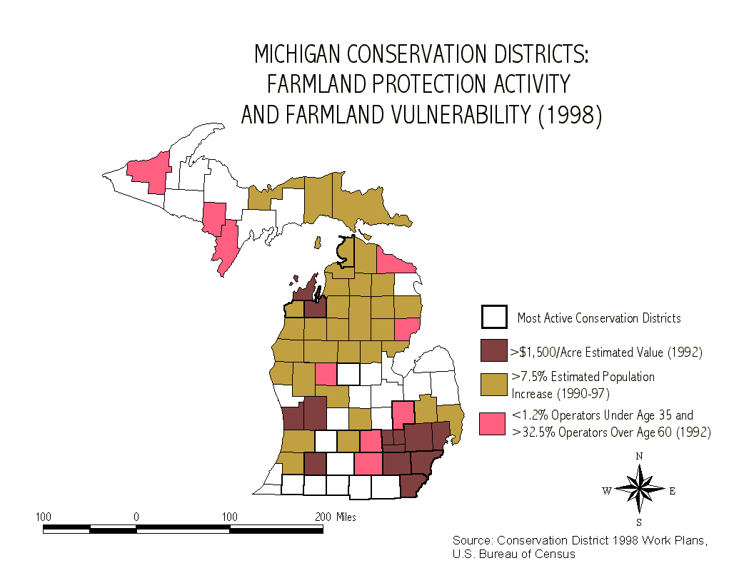
- These criteria were then used to predict farmland vulnerability in 1997, the year that the conservation districts prepared their 1998 work plans. The state mean values for 1992 (the most recent census data available) were used for the farm operator age variable. $1,500 per acre was used for the farmland value variable, and the estimated mean state population growth from 1990 to 1997 was used. A map depicting the districts meeting at least one of these criteria was created.
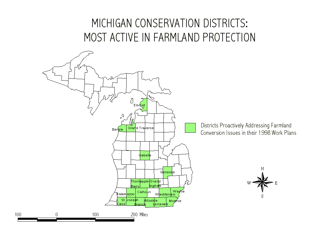
- A map of the districts rated by farmland protection activity was created. A map of the most active districts (those with scores of 4 or 5) was also created.
- The most active districts map layer was overlaid onto the 1997 farmland vulnerability map to compare the relationship between proactive conservation districts and the threat of farmland conversion. This map showed that eight of the eighteen proactive districts appear to be in areas in which farmland is not at risk. Using the Michigan Society of Planning Officials index of farmland risk, 12 districts were in non-threatened areas.
- Individual maps were created for each of the potential indicators of conservation district farmland protection activity. These maps rated the districts according to the following criteria:
- Conservation District Staffing
- Natural Resources Conservation Service Staffing
- Proportion of District in Farmland
- Value of Agricultural Products Produced
- Population Density
- Farm Participation in Federal Land Set Aside Programs
- Farm Participation in Conservation Reserve or Wetland Reserve programs
- The map of most active conservation districts was overlaid onto each of the conservation district farmland protection indicator map layers and individual maps were created for each variable. Visually, it appears that the most active conservation districts score highly on at least one of these variables. Conservation district staffing, NRCS staffing, proportion of district in agriculture, participation in set aside programs, and participation in CRP or WRP appear to correspond the strongest.
- I tried to find the combination of independent variables and cutoff points that each of the most active conservation districts have in common by querying most active conservation districts exceeding various cutoff points for each of the variables The results, however, were inconclusive. Several of the high ratings of independent variables correlated with the most active conservation districts, but I wasn’t able to determine which variables were the critical ones. The correlation tests I had done Excel previously already showed the strongest and weakest correlation between conservation district farmland protection activity and each of the independent variables. At this point, it is probably best to use statistics to analyze the data further.
SUMMARY OUTPUT OF ALL INDEPENDENT VARIABLES AND DEPENDENT VARIABLE OF CONSERVATION DISTRICT FARMLAND PROTECTION ACTIVITY
|
|
|
|
|
|
|
|
Regression Statistics |
|
|
|
|
|
Multiple R |
0.5173 |
|
|
|
|
|
R Square |
0.2676 |
|
|
|
|
|
Adjusted R Square |
0.230041 |
|
|
|
|
|
Standard Error |
1.585976 |
|
|
|
|
|
Observations |
83 |
|
|
|
|
|
|
|
|
|
|
|
ANOVA |
|
|
|
|
|
|
df |
SS |
MS |
F |
Significance F |
|
Regression |
4 |
71.68446 |
17.92111 |
7.124781 |
6.07E-05 |
|
Residual |
78 |
196.1951 |
2.515321 |
|
|
|
Total |
82 |
267.8795 |
|
|
|