A basic principle of mapping
is to take note of recognizable things. The simplest application
of this principle is the use of landmarks. However, the application
of a principle can be frequently useful and yet not wholly scientific.
Science means knowing. Landmarks, familiar features, and oddities
in shape do not enable us to know enough about the location of a point
anywhere. Knowing the exact location of a point or an object is important
in science because many different people at different times and places
may need to find the same object. In order to know exactly where
a place is, we must have a standardized way of knowing its position in
space whether if that space is the surface of the earth or the depth of
the cosmos. So, know we need to ask, what is that standardization?
The Celestial Sphere
A Model of the Sky
The wide open spaces of a broad land are hardly more mappable than celestial space. In fact, it is from the sky that the "ancients" got their cue for measuring the circle. From the same overhead source, they also got the idea of a globe (the first spherical maps were star maps). In fact, the earth sphere is a solid little model of the celestial sphere.
Many ancient astronomers, including Hipparchus, thought of the sky as a great, hollow, crystalline sphere surrounding the earth. The stars, they imagined, were attached to the inside of the sphere like thumbtacks stuck in a ceiling. The sphere rotated once a day, carrying the sun, moon, planets, and stars from east to west. This geocentric view was believed by almost everyone until the Renaissance.
We now know that the sky
is not a great, hollow, crystalline sphere. The stars are scattered
throughout space at different distances and instead of the sky turning
once a day, the earth rotates on its axis. The celestial sphere is
still a convenient model of the sky and is used by modern astronomers when
they think about the location and motions of the celestial body.
Reference Marks on the Sky
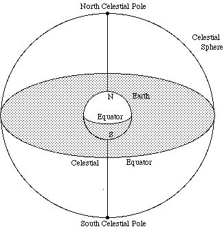
When you gaze up at the sky, you get the impression that it is a hollow dome. The top of the dome, the point directly over our head, is called the zenith and where the dome meets the earth is called the horizon. As the celestial sphere rotates, the objects on it maintain their positions with respect to one another. We can use the fact that the entire celestial sphere seems to turn together to help us set up systems for keeping track of what things are visible in the sky and where they happen to be at a given time.
To help orient us in the turning sky, astronomers use a system that extends out earth's special points into the sky. The line of the earth's axis is extended upward: the points where the axis meets the celestial sphere are defined as the North Celestial Pole and the South Celestial Pole. As the earth rotates eastward on its axis, the sky appears to rotate westward, and the stars located near the celestial poles seem to follow small circles around the celestial poles. In our imagination, we also throw the earth's equator onto the sky and call this the Celestial Equator. It lies halfway between the celestial poles, just as the earth's equator lies halfway between our planet's poles. But when having maps of the stars, there are some important differences from land maps that we need to recognize.
In the celestial sphere, the meridians have the same role as that of the longitude circles on an earth globe. But in astronomy, unlike geography, we do not have east-longitude and west-longitude. It is only with reference to the surface of the earth that the geographer's east and west are very useful as directions. Also, the terrestrial sphere (Earth) is a body and we live outside it. But we and our standpoint, are within the celestial sphere. On Earth, the equator is and imaginary line below our feet, but in the celestial sphere, it is above our heads.
Coordinates
Coordinates are a set of points on some sort of grid that represent an exact location of an object. For the terrestrial globe, we call these set of points longitude (east or west of the prime meridian) and latitude (north or south of the equator). Astronomy uses a similar coordinate system with a few difference.
When an astronomer uses longitude-like coordinates at distances measured off along the celestial equator, he has two names for these coordinates. It the coordinate is one measured toward the "east," he calls it right ascension (an explanation of why he uses these words would be quite lengthy so lets just take it as it is). If the coordinate is one measured toward the "west," he calls it the hour-angle.
While right ascension is based on the annual apparent motion of the sun, the hour-angle is based on the apparent daily solar motion. However, they are both measured from the same point on the celestial equator. This point is called the vernal (spring) equinox you see at March. Through this point and through the north and south celestial poles passes a circle that is called the equinoctial colure. This circle could be seen as analogous to the prime meridian except that its position is always moving in reference to ours. Also, longitude does not stop at 180o as on the earth but is continued all the way around to 360o. This is done no matter how the longitude line is being used. Often, however, instead of giving right ascension or hour-angle of a star in degrees, it is measured in hours, minutes and seconds.
What about the coordinate that corresponds to latitude? This is much simpler that longitude. As on the terrestrial sphere, it is a measure of distance (or angle) away from the equator. The astronomer's name for it is declination. It is expressed in degrees, minutes and seconds. Keep in mind when you are looking at stars that the latitude (declination) of a star and its altitude in the sky are not the same thing. The stars altitude is a measure from the horizon while declination is a measure from the celestial equator.
Let's take a look at the above coordinate system in use.
Usually when we see Orion he looks like this:
However, when we use the coordinate system, he looks like this: 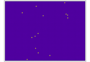
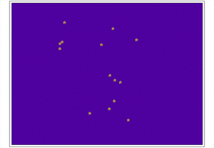
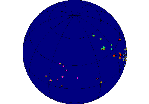
Why the difference? The coordinates are based on using a globe to represent the sky (just like the globe is used with Earth). Therefore, when stars are plotted using the coordinate system, it gives you a picture of what the sky would look like from outside of the globe. To see this in motion, we have also set up a sample image of the celestial sphere from the outside. If you want to see what the celestial sphere motion would look like if the Earth spun in the opposite direction (east to west), return to the home page and click on the words, A Different Spin.
Click here to find out more about the coordinate
system used to create these maps.
| Home |