HOME
|
HOME |
|
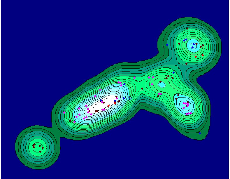
What follows is a series
of maps showing density contours of sites dating to different periods in
the Rio del Oso Valley. Density contours express site densities
as contour intervals. Intervals are set at 5 percent, meaning that
site percentages increase by 5% with each contour layer. Lighter
colors represent high density site locations. Density contours help
to visualize site clustering and prepare data for further statistical analyses
dependent upon cluster membership. Through time, sites cluster at
the edges of Pleistocene terraces in the valley, and are situated along
the Rio del Oso drainage and one of its tributaries. Trends include
continued use of these terraces, probably for wild or domesticate plant
harvesting, In historic times, the valley was partitioned by two
groups, tipi dwelling Jicarilla and Hispanic settlers.
During Archaic times (dating from 5500BC to AD400), there is a focus on the second Pleistocene terrace, which when viewed topographically, includes an expansive lower terrace good for wild plant harvesting and possibly small-scale gardening of domesticated maize. Although Archaic hunter-gatherers may have taken advantage of the plant products in this area more intensively, sites are nonetheless widely distributed across the valley, indicating a generalized use of the landscape during this time.
Archaic sites color-coded
by phase
Archaic sites color-coded
by site type.
During Puebloan times
(AD400-AD1600), full-scaled agriculture develops in the valley. In
contrast to Archaic times, there is a more even distribution of Puebloan
sites and a more intensive utilization of several terraces in the valley.
The first Pleistocene terrace, however, was more intensively occupied (as
evidenced by white contour layers). Population in the valley peaks
during the Coalition to Classic transition (AD 1200 to AD 1600) when large
pueblo villages were located near the first and second Pleistocene terraces
primarily. Small dwellings occur between terraces and these are probably
related to agricultural fields dispersed throughout the valley.
When compared to Archaic site distributions, contour plots indicate a slightly
more intensified and focused area of occupation in the valley by Puebloans.
This can be seen as differences in the shape and size of contour plots
between these two periods. The Archaic period contour plot is slightly
larger with most habitation occurring on the second terrace. Puebloan
site distributions produce a contour plot slightly more restricted in size
and shape with high densities of sites located on the first and second
terraces.
Pueblo sites color-coded
by phase
Pueblo sites color-coded by site type
Pueblo sites color-coded
by their association with agricultural features
After a short hiatus of about 200 years, occupation in the valley continues during the 1800s. In contrast to the previous patterns of site distributions, use of the valley during historic times is more restricted. The valley also was occupied by both the Jicarilla and Hispanic settlers simultaneously. Jicarilla sites cluster on the second terrace primarily. These are small tipi sites with abundant scatters of Jicarilla pottery surrounding them in a wide radius. Large tipi sites occur in in the lower reaches of the valley where site type diversity is low. Within each of the clusters representing Jicarilla sites, wagon roads traverse from soutwest to northeast. The Jicarilla utilized the valley during the mid to late 1800s where they were reported to be farming and making pottery for sale to local settlers. Despite radically different spatial patterning of Jicarilla and Archaic sites, both groups utilized the second Pleistocene terrace intensively, suggesting similarities in landscape use by semi-sedentary hunter-gatherer, horticulturalists. Hispanic activities in the valley include sheep herding and farming. In general, sites are fewer and more widely distributed with most sheep-herding activities taking place along the lower reaches of the Rio del Oso. The Hispanic settlement of Rio Oso, Rio Oso, located on the third (leftmost) Pleistocene terrace, was occupied seasonally and occurs atop a large Pueblo site with related agricultural fields. Interestingly, the Jicarilla and Hispanic farmers partitioned space in the valley fairly discretely, but interactions are evidenced by low densities of Apache sherds and tipi rings near the settlement of Rio Oso, Rio Oso. Future research will investigate the nature of these interactions. Interestingly, the Site of 100 Tipis, the other Apache site featured in this research, is also closely associated with Hispanic settlements. This information complements historical records and oral history that states Hispanics and Jicarilla maintained critical economic ties in the past. Future studies will focus on the kinds and quantities of artifacts representing trade items between Hispanics and Jicarilla in the Rio del Oso.
Jicarilla sites color-coded
by site type
Hispanic sites color-coded by site type
|