


| The scale to which a map is drawn represents the ratio of the distance between two points on the earth and the distance between the two corresponding points on the map. |
| Map Scale | = | Map
Distance
--------------------------------- Ground Distance |
| Types of Scale | ||
|
When a scale is expressed in words, for example one inch represents one mile, it is referred to as a Verbal Scale. |
Almost every map has a bar scale, or a Visual Scale, that can be used for measuring.It shows graphically the relationship between map distance and ground distance. |
|
| Representative
Fraction
The scale of a map, expressed as a numerical ratio of map distance to ground distance, is called a Representative Fraction (or RF). It is usually written as 1/50,000 or 1:50,000, meaning that one unit of measurement on the map represents 50,000 of the same units on the ground. |
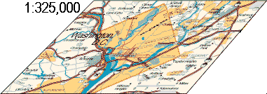
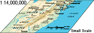
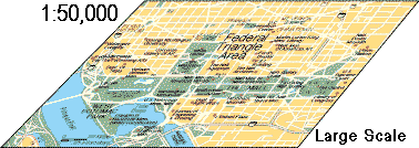
| Changing Scales
The maps shown here show the effects of scale changes moving "closer to" or "farther from" the earth. A large scale map shows a small area with a large amount of detail. A small scale map shows a large area with a small amount of detail. |
|