 |
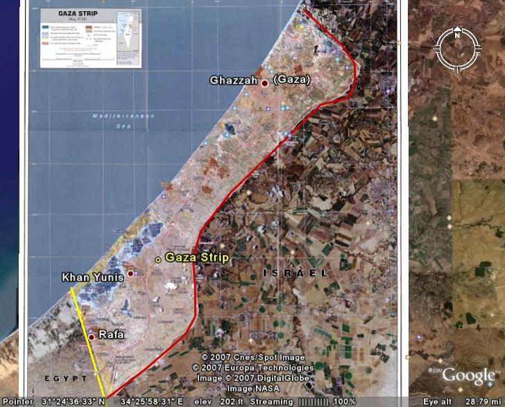
The Gaza Strip is located in the Middle East (at ). It has a 51 kilometers (32 mi) border with Israel, and an 11 km border with Egypt, near the city of Rafah. Khan Yunis is located 7 kilometers (4 mi) northeast of Rafah, and several towns around Deir el-Balah are located along the coast between it and Gaza City. Beit Lahia and Beit Hanoun are located to the north and northeast of Gaza City, respectively. The Gush Katif bloc of Israeli localities used to exist on the sand dunes adjacent to Rafah and Khan Yunis, along the southwestern edge of the 40 kilometers (25 mi) Mediterranean coastline. A few months after the disengagement in December 2005, a controversial buffer zone was created on the northern border with Israel, in the area often used to launch Qassam rockets into Israel. Part of it reaches 2.5 kilometers (1.6 mi) into the Palestinian Authority-controlled territory, on roughly the area of the former northern Israeli localities. The Gaza Strip has a temperate climate, with mild winters, and dry, hot summers subject to drought. The terrain is flat or rolling, with dunes near the coast. The highest point is Abu 'Awdah (Joz Abu 'Auda), at 105 meters (344 ft) above sea level. Natural resources include arable land (about a third of the strip is irrigated), and recently discovered natural gas. Environmental issues include desertification; salination of fresh water; sewage treatment; water-borne disease; soil degradation; and depletion and contamination of underground water resources. The Strip currently holds the oldest known remains of a man-made bonfire, and some of the world's oldest dated human skeletons. It occupies territory similar to that of ancient Philistia, and is occasionally known by that name. |
Map of the Gaza Strip Overlain on a Satellite Image

More Basic Information on the Gaza Strip
Gaza Strip- MSN Encarta
The Gaza Strip- CIA World Factbook
BBC Profile: Gaza Strip
Gaza Strip- Wikipedia
Interactive Map of Israel- The Jerusalem Post