 |
 |
 |
| The Nile River is a prominent feature of the modern cityscape of Cairo, Egypt. |
| DOD, Defense Visual Information Center, March Air Force Base, CA |
 |
|
|
 |
|
 |
|
|
|
|
|
Location, location, location
The Middle East is at the junction of trade routes connecting Europe
and China, India and Africa, and all the cultures of the Mediterranean
basin. Many of these routes have been documented from as early as 5,000
years ago, and the presence of so many different people and products
over the years has had a profound effect on the region's culture,
politics, and economy.
More than deserts and camels
The landscape of the Middle East is more diverse than the deserts
that dominate movie screens and novels would suggest. Rivers allowing
for productive agriculture were the key factor in the settling of
cities. Mountain ranges kept cultures in separate areas, providing
natural barriers to imperialist agendas.
|
|
|
|
 |
 |
|
|
A fertile bank of the Nile River in Egypt [ enlarge ] |
|
|
|
|
|
The rich, fertile soil of the Middle East led early civilizations to settle, domesticate plants and animals, and thrive. The
Fertile Crescent
between the Euphrates and Tigris Rivers known as
Mesopotamia
(now modern Iraq, and extending north into Syria
and Turkey) was the home of the world's first urban culture, the
Sumerians, 6,000 years ago. The Sumerians' Egyptian rivals took
advantage of the annual flooding of the Nile for their regular harvest,
later exporting a large portion of their produce to the Roman Empire.
Some time later, the Hittites settled in the golden, rolling hills of
Anatolia
(modern Turkey) and the Phoenicians of the
eastern Mediterranean loaded olive oil and spices into their merchant
ships to trade throughout the Mediterranean.
This region introduced many staples into the kitchens of the world,
including olives, figs, lemons, coffee, chickpeas, lentils,
pomegranates, and asparagus. The cedar trees covering the hills of
Lebanon were forested in ancient times for their fragrant and
structurally reliable wood.
|
|
|
|
 |
|
|
|
|
Lebanon's Bcharre Village sits at the base of a picturesque mountain range. [ enlarge ] |
|
|
|
|
|
The mountain ranges in the Middle East helped isolate various
cultures from each other as much as, if not more than, bodies of water.
The Taurus Mountains of southern Turkey separate Anatolia, also known
as
Asia Minor,
from the rest of Asia, just as the Atlas
Mountains separate Morocco from the rest of Africa. Iran's Elburz and
Zagros Mountains are high enough to host ski resorts.
In tumultuous times, mountains have also provided refuge for
oppressed minorities, such as the Ismailis in Afghanistan; the Alawites
in Syria; the Christians in Lebanon; the Kurds in Turkey, Syria, Iran,
and Iraq; and the Berbers in North Africa.
A well-traveled route
The
Silk Route
refers to the trading routes stretching from
China through Central Asia to the Middle East. (Even when Europe
participated in this overland exchange, traders continued through the
Middle East to avoid having to cross the Caspian Sea to the north.)
Silk Route merchants were the first to introduce Chinese products like
paper and gunpowder to the West. The people who traveled these roads
exchanged not only products, but, maybe even more importantly, ideas --
scientific, religious, and artistic -- that would challenge and change
institutions in China as well as in the Middle East.
Perhaps the most significant movement of people on this route was
the Turks' migration into Anatolia. The Christian Byzantines had ruled
Byzantine from Constantinople in western Anatolia for four centuries,
with the Taurus Mountains providing a natural barrier against their
Muslim neighbors to the south and east. The victory by the Seljuk Turks
over the Byzantines at the
Battle of Manzikert
in 1071 in southeastern Anatolia opened the way for Turkish tribes to settle in Anatolia and provoked the first European
Crusade.
|
|
|
|
 |
|
|
|
|
Ships make their way in an orderly fashion through the Suez Canal,
which connects the Red Sea with the eastern Mediterranean. [ enlarge ] |
|
|
|
|
|
Although it was religious wars that first introduced European armies
into the region, the strategic location of the Middle East was the
motivation for a continued European presence in the 19th and 20th
centuries. The British and French both coveted a route to India and
Southeast Asia. The building of the
Suez Canal
in Egypt (completed in 1869) allowed military
and commercial ships to pass between the Mediterranean and Red Seas and
into the Indian Ocean, rendering the long and dangerous trip around
Africa unnecessary.
Geographical features bring economic and political riches
Geography and natural resources have always influenced political
power in this region. The Nile and Mesopotamian Rivers can support a
rich agricultural base, but only if the water distribution can be
sustained and controlled through irrigation systems. And the prosperity
of these regions has depended on a government's ability to maintain
irrigation systems over the long term. If a central government can keep
the irrigation systems in good working order, then well-irrigated
fields produce more crops, which can then be taxed to support the
government. Conversely, when local populations do not cooperate to
maintain a stable government, their crop yields may drop.
|
|
|
|
 |
|
|
|
|
Cultivated land near Turkey's border with Iraq [ enlarge ] |
|
|
|
|
|
Mesopotamian farmers used
Persian Gulf
seawater to irrigate for centuries, and now, as
a result, much of southern Iraq's soil is too salty to grow crops.
Agriculture in the region now relies on modern practices like fresh
water irrigation, rotating crops each year, and technologically
sophisticated dam projects.
Today, the wealth in Middle Eastern soil comes not from crops, but
from petroleum. This region contains about two-thirds of the world's
known petroleum reserves, the geological remnants of lush tropical
forests of eons past. When the United States and Europe increased their
consumption of oil drastically during World War II, the oil reserves in
the Middle East became critically important to U.S. foreign policy, and
have remained so ever since.
Human geography
The ethnic and cultural diversity of the population of the Middle
East is as varied as any place on earth, save the New World. People in
the Middle East live a variety of lifestyles -- nomadic and
semi-nomadic, farming and fishing, and, increasingly, urban.
|
|
|
|
 |
|
|
|
|
Shepherds move their flocks along a desert road in Israel. [ enlarge ] |
|
|
|
|
|
How people put food on their tables is intimately tied to their
physical surroundings. While the herding lifestyle of the nomadic
peoples of the Middle East may have captured the romantic imagination
of Europeans and Americans, in reality, pure
nomads
have always been a small minority in this
region. In fact, many so-called nomads were simply seasonal migrants
who grazed their livestock in one region in the summer and moved
elsewhere in the winter. These migratory populations gained a
reputation for breeding fine horses and camels, although most supported
themselves raising sheep and goats. This system of seasonal migration
functioned well until modern states established exclusive ideas of
property and land ownership.
Most states in the region with large nomadic or semi-nomadic
populations have pursued a settlement policy in order to better track
and control the historically independent tribes. Clan and family
relationships are still a vital part of their social structure.
Other families depend on the sea, or rivers, for their sustenance.
The long Mediterranean, Persian Gulf, and Red Sea coastlines and large
river systems of the region support many communities through both
fishing and water-borne trade. The pearl industry of the Persian Gulf
spawned a specialized economy there.
Productive areas of both rain-fed and irrigated agriculture support
rural farming populations, which are usually organized as tight-knit
villages rather than isolated farms. Village identity is extremely
strong, so much so that when people migrate to the city or even abroad,
they often settle in communities of their co-villagers. A neighborhood
in Detroit, for example, may be made up of immigrants from one
particular village in Lebanon. Immigrants often aspire to earn enough
money to return to their village, buy land, and build a large home.
|
|
|
|
 |
|
|
|
|
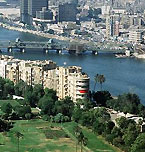
The Nile River is a prominent feature of the modern cityscape of Cairo, Egypt. [ enlarge ] |
|
|
|
|
|
Rapid urbanization has been a marked feature of the Middle East in
the late 20th century. Cairo, Istanbul, and Tehran each have more than
10 million residents and continue to grow. While migration to the
cities offers attractive opportunities of employment and modern
amenities to poor villagers, the rapid rise in urban populations has
strained water resources, transportation facilities, and other public
services as well as contributing to pollution.
What's in a name
Many different terms have been used to describe this area of the
world, and although various geographic and cultural descriptions have
major overlaps, each may significantly exclude different regions.
The region can be referred to most neutrally by continental terms, such as "West Asia" or "Southwest Asia and North Africa."
Linguistically, the "Arab world" includes the Arabic-speaking
countries from North Africa, Southwest Asia, and the Arabian Peninsula,
but excludes Iran, Turkey, and Israel.
The "Islamic world" includes all of the Arabic countries, as well as
neighboring Turkey and Iran. Other nations that are predominantly
Muslim, like Indonesia, Pakistan, Afghanistan, and many sub-Saharan
African countries, should be considered as integral parts of
the Islamic world, but terminology for the region often omits them. In
addition, there are significant populations of Christians, Jews,
Zoroastrians, and other religious groups that live in these same
nations that make up the so-called Islamic world.
The "Middle East" is a term derived from a European perspective. For
19th-century Europeans, the Middle East was differentiated from India
and the Far East (Southeast Asia and China). Originally, the
Near East
referred to areas under Ottoman control, from
the Balkans to the border of Iran. The term Middle East was introduced
in the early 20th century to include the area around the Persian Gulf,
and the Near East was used to refer to the Ottoman Balkans. After World
War II, Middle East became the dominant term for the whole region.
Because "Middle East" is an outsider's term describing neither
geography nor culture, it is an ambiguously applied name. For some, it
refers to the area bounded by the Mediterranean Sea, the Arabian
Peninsula, and the Taurus and Zagros Mountains. For others, Egypt,
Arabia, and the Persian Gulf states fall under their description of the
Middle East. Still others use the term as a synonym for the Arab world,
sometimes including Turkey and Iran based on their proximity and
linguistic and religious affinities to the region. Despite its foreign
origins, the term "Middle East" has been translated and adopted into
many Middle Eastern languages, including Arabic, Hebrew, Persian, and
Turkish.
Back to top
Related sites
New Allies:
http://www.pbs.org/newshour/bb/asia/jan- june02/allies_3-12.html
NewsHour reports on the allies America has gained since the attacks of September 11. (March 2002)
Afghans Battle:
http://www.pbs.org/newshour/bb/military/ july-dec01/reporters_12-7.html
Two reporters discuss the latest military action in Afghanistan,
including the fall of Kandahar and the continuing search for Osama bin
Laden. (December 2001)
The World Factbook 2001:
http://www.odci.gov/cia/publications/factbook/index.html
The Central Intelligence Agency publishes information on the
geography, people, government, and economy of each Middle Eastern
country.
Commanding Heights Web Site:
http://www.pbs.org/wgbh/commandingheights/
An economist's look at world history and development from 1910 to the present
What Happened to the Near East?:
http://www.houstonreview.com/articles/NearEast.html
An explanation of the terms "Near East" and "Middle East"
Physical Features of the Middle East:
http://geog.tamu.edu/vatch/mideast/photos/photos320.html
Photographs of the Middle East taken by satellite
The Politics of Oil:
http://www.gliah.uh.edu/historyonline/oil.cfm
An essay on the history of oil production
Historical Maps of Islam:
http://ccat.sas.upenn.edu/~brvs/pages/maps.html
Historical maps of Islam
Map of Israel and the Occupied Territories:
http://www.pbs.org/newshour/bb/middle_east/conflict/map.html
A map of Israel and the Occupied Territories
Getting to Know Iran:
http://www.pbs.org/visavis/resources_mstr.html
Students will become familiar with Persian Gulf geography, religions, cultures, and government.
Related topics
How were modern nation-states of the Middle East created?
What have been the role and effects of U.S. foreign policies and actions in the Middle East?
What role have natural resources played in the politics and economy of the Middle East?
Culture: A Rich Mosaic
Related maps
Historic Political Borders of the Middle East
Middle East Topographic and Natural Resources
Middle East Religion, Ethnic Groups, and Language Distribution
Muslim Population Worldwide
Israel's Changing Borders
|
|
|

|
