
by
Larry
"Harris" Taylor, Ph.D.
This
is an electronic reprint and expansion of a portion of a three part series on river diving
that appeared in SOURCES (Nov/Dec.1989,
p. 27-30.). It also appeared in BEST OF SOURCES (230-232).
This material is copyrighted and all rights retained by the author. This
article is made available as a service to the diving community by the author.
This article may be distributed for any non-commercial or Not-For-Profit use.
All
rights reserved.
Swift
water river diving can be extremely hazardous. Although knowledge from reading
may assist the diver’s understanding of the environment in which the diver has
chosen to play, there is no substitute for proper training. River diving is a
specialty that demands techniques and equipment beyond most recreational
training.
Go To: Home About "Harris" Articles Slides War Stories Editorials Links Fini
Recreational divers play in swift water rivers for a variety of reasons. There is, of course, the thrill and challenge of maneuvering in swift water; the ever changing current makes each dive unique, even when diving the same location a multitude of times. Historically, rivers have been highways for westward expansion, exploration and commercial development. This means that sailors, explorers and settlers have used river systems as garbage dumps for centuries. Thus, river divers find old bottles, coins, artifacts, and antiques (anything that anyone at anytime could accidentally or purposefully discard). One never knows what is to be found on any given river dive. In addition, many rivers provide divers an opportunity to recover inadvertently abandoned anchors, fishing lures and sinkers and all sorts of small boating equipment lost by recreational boaters and fishermen. Rivers along political borders have often been areas of smuggling; as such, contraband and may still be found in some locations. Some heavily trafficked rivers provide a variety of wrecks upon which to play. Basically, anything people can lose or discard, can, at some time or another, be found on a river bottom. Some rivers offer interesting geological finds ranging from fossils to a variety of minerals, including gold, as well as being archeological sources of artifacts from times past. Finally, there are those divers who assist scientists and naturalists study the river ecosystem and commercial divers who install and watch over man-made structures immersed in the river water.
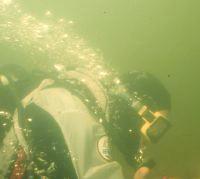
"Treasure" from an inland river: old bottles and fishing tackle
One river system that has generated a substantial international diving population is the St. Clair River. This 40-mile stretch of water connects lower Lake Huron with Lake St. Clair and serves as a border between Canada and Michigan. It is one of the world's busiest rivers. Each year more than 27 million tons of commercial cargo passes along this waterway. Recreational boat traffic from the U.S. (Michigan has the most registered boats in the U.S.) and Canada add to this traffic. All the water draining from the upper Great Lakes of Michigan, Superior and Huron passes through this river on its way to the sea. The current flow here is more than 90 million gallons of water per minute. At Port Huron, under the Blue Water Bridge, the river narrows to a few hundred feet; current here consistently exceeds 10 knots.

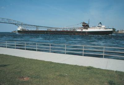
St Clair River (blue line: upper right) Freighter moves under the Blue Water Bridge
The abundance of recoverable objects, the presence of many wrecks, the large fish population, and the utter thrill of drifting in currents exceeding 2-3 knots attract divers from a variety of regions. Many divers have died in this river. (There are 1-2 scuba diving deaths on the American side of this river annually.) Divers will, unfortunately, continue to die here. Divers have a remarkable ability to overestimate personal skill while simultaneously underestimating the awesome force of swiftly moving water. With proper training, physical fitness and equipment, swift water river diving can be an exhilarating experience. Without such training, conditioning and equipment, the river can be a terrifying and fatal place to play.
Hazards
The primary hazard in river diving is the current. The moving water can, without apparent warning, change direction and intensity. Often, swift currents are associated with poor visibility. Diving under these conditions can be like driving 100 mph at night, in the rain with only parking lights. Divers without an appreciation of limited visibility or what moving water can do are highly stressed, subject to disorientation and terror. Many river diving fatalities are divers doing their first river exploration. Regardless of previous diving experience, all divers entering swift river water (current greater than 2 knots) for the first time should do so under the direct 1:1 supervision of a locally knowledgeable experienced river diving instructor. Specialty sport diving classes in such intense current should be on a 1:1 student: instructor ratio.
The
rules are different in the world where bubbles do NOT go straight
up! Most
river bottoms are not absolutely smooth, so there is a constant problem of being
snagged in a whole host of structures, both natural and man-made.
This problem is compounded if there is active fishing in the area because
the thousands of miles of monofilament lines on our river bottoms are often
invisible, until entanglement has occurred. There is a danger of lacerations or puncture wounds from the abundant
junk that litters the river bottom. In swift water there is often little time to
avoid sharp edges from logs, pilings, wrecks, broken glass, junk metal, and
fishing lures. The current constantly erodes everything and many underwater
structures ultimately become unstable. Some
river waters are polluted from sewage or industrial manufacturing wastes. The
moving water increases heat loss and hypothermia can be an additional problem.
Finally, river diving can be strenuous and so physically demanding that
exhaustion of self and air supply becomes a real problem.
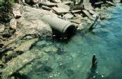
Effluent from drains & current around
pilings are unpredictable Dikes
and jettys are built to channel current flow. The currents around these devices
are often strong and unpredictable. They should be avoided, particularly by
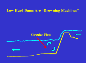
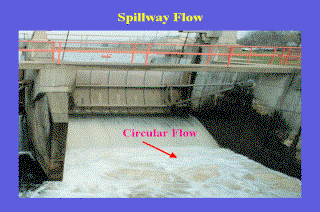
novice river divers. Some river systems have spillways and dams. The immediate
downstream region from these spillways forms a zone of continually recycling
water (a "hydraulic") that may be impossible to leave. Such zones have
been responsible for many deaths and have earned low-head dams the nickname
"the drowning machines." Diving immediately downstream from dam or
spillway structures is hazardous and should not be done by recreational divers.
Even a small dam with a drop of only a few feet has a water force sufficient to
trap swimmers and divers. Many such small dams have been responsible for
diver fatalities.
Reading
the River River divers should have some
understanding of the environment in which they play. In general, the depth of a
river is somewhat weather and seasonally dependent. Depth will increase after
heavy rains and decrease during long hot spells with no rain. Ice and man-made
structures can form dams and back-up the river, increasing depth. In some
locations, strong consistent winds can "pile-up" water on one side of
a body of water. In tidal locations, "bores" or the tidal movement of
water can reverse current flow and drastically change water depth, current
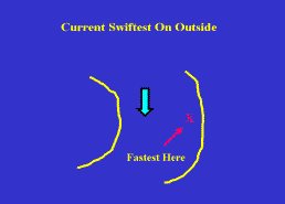
intensity and visibility. The depth is generally the deepest on the outside of
the river bend. Here the bank can provide a clue, if the bank is steep, then
most likely that steepness will continue underwater. If the bank is a gentle
slope, then the river bottom will continue in the same fashion.
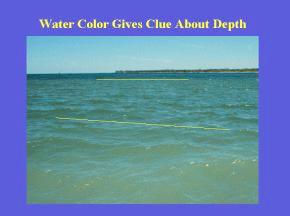
Watercolor will also provide clues to the bottom. In the illustration below left, there
are two distinctly sharp increases in water depth as indicated by a much darker
watercolor and the thin yellow lines.
Actual current flow may
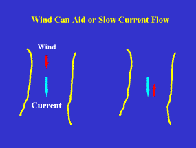
vary daily and most definitely with the season. The current is the swiftest on
the outside of a bend. Local winds
can increase or decrease the current velocity depending on whether they aid or
oppose the current. In the St. Clair system, which runs north-to-south, a north
wind increases current velocity. This in turn picks up more silt and visibility
in the river goes to near zero. Strong southern winds, however, will directly
oppose the force of the current, the finer particles will drop and visibility
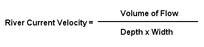
improves. The velocity of current, given constant volume, is a function of the
width and depth of a river.
As
the river narrows or grows shallower, the velocity will increase. This is the
situation at the mouth of the St. Clair system. Current flow, as measured by
NOAA, is roughly 90 million gallons a minute. Actual current velocity will vary
from greater than 10 knots to less than 1 knot, depending on width and depth of
the river channel at the point being measured. The increase in velocity over
shallow portions of swift moving water is particularly noticeable to divers at
depth. So, divers on a drift should anticipate an increase in current velocity
as the bottom depth decreases. Likewise,
a drop in bottom contour will generally slow current. A sharp drop may
also warn of an about-to-be-encountered upstream component of an eddy current.
Sometimes these eddy's will be accompanied by a dramatic change in current flow direction:
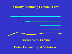
this can result in rapid changes of a diver's depth. Ideally,
river water will move downstream in parallel ("laminar") sheets, each
layer closer to the bottom moving slower. The friction from the bank and bottom
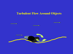
will decrease the velocity of the current. As one approaches irregular banks or
bottoms the flow becomes more turbulent. Indeed in some locations, in intense
current, one feels like one is in the middle of an underwater thunderstorm. The
fastest drift will be in the center of the river near the surface. The smoothest
drift looking for collectables will be in the center of the river near the
bottom. (Note, however, that the center of the river may often be too far from
shore to find too many "goodies".)
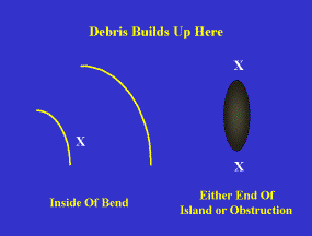
Islands
or large submerged objects will "split" the current flow and current
velocity at both ends of such objects will decrease. This leads to a "dumping" effect and debris (or
shoals) will accumulate here. Indeed, both ends of an island are excellent
places to search for artifacts and bottles. Note that this dumping effect
decreases the visibility and this is why visibility in shoal areas and the
inside of bends is usually less than other areas of the river. Whenever water
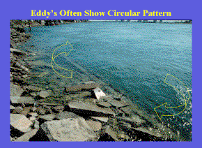
moves through restrictions or around objects an "eddy" current may
form. Eddy currents can be visualized as water moving against the primary
current to "back-fill" an abandoned space. They can form behind any
object in the river and can be used as resting locations (in the same manner as
a canoeist will use an eddy to rest and scout downstream water). In some
locations, the eddy current offers substantial upstream movement and divers can
use this current to move upstream. Large
eddy systems can be fun to dive. You enter the water and allow the eddy to take
you upstream and then return to the original entry point on the downstream
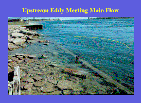
current. Note that where the eddy current meets the downstream current, there is
often a zone of turbulence and decreased visibility. These zones are also good
areas to look for "goodies" because the sudden decrease in downstream
velocity will cause objects carried by the current to drop to the bottom. The
sudden appearance of sand on an otherwise rocky bottom can be a clue that you
are about to enter a substantial eddy current.
The circular flow of an eddy
system is often apparent from above. Knowledge of existing eddy systems can be
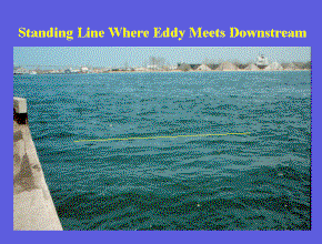
very beneficial to divers. There is often a "standing" line where upstream and
downstream portions of current flow collide. This can provide pre-dive clues.
This collision of flow often results in the dumping of carried debris. So, in a
downstream drift, the presence of a line of silt crossing the path of the
drifting diver can provide an alert that an eddy is about to be encountered.
This can also serve as a reference to divers position along the shoreline. It
can also assist exits in known areas. For example, there is an area of the St.
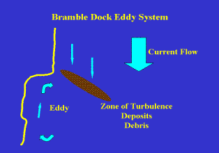
Clair river system that is often a diver's exit point. This site, the Bramble
Dock, is nearly always in a strong eddy system.
While drifting downstream, the presence of a large sandy area
perpendicular to current flow provides a clue that the eddy system is about to
be entered. Since this is near a common exit point, divers will often move close to shore.
This puts them in the full force of the eddy and they must therefore expend
energy (consume more air) to move along this section of the river to their exit
point. A river knowledgeable diver will sense the eddy and move out a bit and
let the eddy can the diver to the exit point.
Although
rivers share many common hazards, each system is unique. Each different river
can provide divers with a unique and special thrill. Divers should always
consult local diving authorities to establish local conditions before diving.
River diving, like any specialty diving, can provide the diver with an
exhilarating experience. The thrill of swift current drift diving gives new
meaning to the term "diver's high." Divers who approach their diving
by obtaining proper training and equipment will find that there is great truth
to the rumor that "knowledgeable, physically fit divers have more
fun!" This is one portion
of series of articles on river diving. Others are River Diving: Equipment
River
Diving: Navigating In Currents River
Diving: Technique Lecture
Slides for the river diving course at River Go
To: Home About
"Harris" Articles
Slides
War Stories
Editorials
Links
Fini Photo
Credits: Surface
Photography: Larry "Harris" Taylor Diver
Underwater: Mike Spears St.
Clair River Map: LANDSAT Image Larry
"Harris" Taylor, Ph.D. is a biochemist and Diving Safety Coordinator
at the University of Michigan. He has authored more than 200 scuba related
articles. His personal dive library (See Alert Diver, Mar/Apr, 1997, p. 54) is
considered one of the best recreational sources of information In North America.
All
rights reserved. Use
of these articles for personal or organizational profit is specifically denied.
These
articles may be used for not-for-profit diving education