|
Walpole: The Prairies of Walpole Island
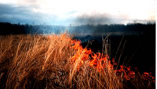
This article was by Allen Woodliffe (District Ecologist for the Chatham district of the Ontario Ministry of Natural Resources) and Marjorie Williams (the former Natural Heritage Program coordinator at the Walpole Island Heritage Centre)Clouds of smoke billowed, forced, upward by heat convection produced by angry flames. Soon, the biomass of vegetative growth was consumed by the hungry, orange tongues of fire, leaving in its wake nothing but swirling blackened ashes. Relentlessly, the flames raced on, eagerly devouring anything in its path. Once across the meadow, the fire reached the roadway. But with nothing left to satisfy its voracious appetite, it sputtered and died.Was this some evil monster out of control, spreading death and destruction across the landscape? No, although a casual observer could have easily concluded just that. No, this was a prairie fire, a phenomenon so natural and incredibly essential that without it, tall prairie would not survive as spectacularly as it otherwise might. The location of this prairie fire was not in the mid-west states of the United States, as was often the case until about 150 years ago. This prairie fire took place in Canada - in Ontario. Ontario? Tall grass prairie occurs in Ontario, you ask? Prairie is well known from those three western prairie provinces, but wasn't Ontario once nothing but wall-to-wall, deep, dark, virgin forest? Not quite. At least not in the extreme southwest section of the province where, accordingly to early surveyor's reports, as many as 40,000 hectares were, at one time, tall grass prairie or related vegetation.
Some of the earliest European pioneers encountering these North American tall grass prairies believed that if the land couldn't grow trees, then it must be quite useless. Considering that many of these travelers had spent most, if not all, of their lives in the heavily forested regions several hundred kilometers to the east, this isn't all that surprising. However, some of the more perceptive ones thought the deep, black soils had excellent potential. And once they had discovered a way to turn over the almost impenetrable prairie sod, they were rewarded with tremendous crop productivity. Soil maps of southern Ontario confirm that extensive portions of Essex, Kent, and south Lambton countries contain the well developed, rich, black prairie soils . These areas support some of the most productive corn and Soya bean operations in Ontario, just as they do in the U.S. corn belt states. Today,there's hardly even a hint of prairie left to explore - unless one know where to find them.Of the estimated 1,000,000 square kilometers of tall grass prairie that once occurred in North America, less than one six-hundredth of one percent remains. In Ontario, small vestiges remain, tucked away in various corners. Probably the two best known remnants are at Windsor and Walpole Island. The prairie related areas of Windsor are mostly publicly owned. They consist of a combination of tall grass prairie, oak savannah and oak forest habitats totaling approximately 350 hectares. The Ontario Ministry of Natural Resources is responsible for managing a sizable portion of this publicly owned remnant with the city of Windsor's Department of Parks and Recreation administering much of the rest. This prairie is easily accessible and boasts an excellent nature interpretation centre. However as significant and spectacular as Windsor's prairie is - with over one hundred plant species rare in Ontario and Canada - the Walpole Island prairies and savannahs are even more impressive. Superior in both size and overall quality, Walpole is undoubtedly the best place to get a glimpse of what prairies at the eastern edge of the range must have looked like prior to European settlement. That's not say that there haven't been threats and changes here. But by comparison to natural areas on the mainland, Walpole is a national treasure indeed. The Setting
Walpole Island Indian Reserve is part of a large island delta complex situated in the mouth of the St. Clair River at the north end of Lake St. Clair, in Lambton County, Ontario. Approximately one-third of the delta is made up of more that a dozen islands on the United States side of the border. The remaining two-thirds are composed of six larger islands on the Canadian side, with the St. Clair International Seaway being the dividing line. The Canadian islands are wholly occupied by the Walpole Island First Nation, and cover about 24,000 ha. Almost 8,000 ha consist of 'dryland' of which half is devoted to agriculture, while the other half is comprised of forest, savannah and prairie. The remainder of the reserve, almost 16,000 ha, is wetland, consisting of marshes, sloughs, interior lakes, channels and adjacent waters of Lake St. Clair to a depth of approximately two metres. Walpole's rich marshland contributes food such as ducks, muskrats and fish. The dryland provides other game as well as plant life for food, medicines and other materials. The water flowing by is essential for drinking and also transportation. But the native people's relationship with the land is much more than simply a source of food and other life sustaining elements. It involves a spiritual dimension, resulting from centuries of coexisting with the land as a culture of hunters and gatherers. So when the water becomes polluted from upstream industry and agriculture, it affects native people culturally, spiritually, nutritionally, socially and economically. Although Walpole Island has long been known for its natural resources, its Indian Reserve status has rendered it fairly inaccessible compared to the Windsor site. Hence, there have been only sporadic visits by naturalists over the decades, including C.K. Dodge, in 1914 and L.O. Gaiser from 1957-64. Preliminary biological reports were filed by two separate consultants in the 1970's, and in the 1980's quantitative sampling of the prairies and savannahs was the subject of two separate post-graduate research studies.
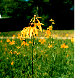
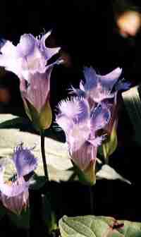
The Study In 1985, a two year study was initiated to compile existing information and to carry out an extensive field survey of the life science features of the terrestrial natural areas of Walpole Island. This was conducted primarily by the Ontario Ministry of Natural Resources (OMNR), with substantial support coming from the World Wildlife Fund (Canada), University of Waterloo, Lambton Wildlife Incorporated and, of course, the Walpole Island First Nation. Under the umbrella of the Walpole Island First Nation research program named NIN.DA.WAB.JIG (meaning 'those who seek to find') which operates from the Walpole Island Heritage Centre. Here, primary research emphasis is on the Reserve's environmental, social-economic and resource management problems. Extensive liaison with and support from staff of the Walpole Island Heritage Centre has been invaluable in carrying out OMNR's recent field survey.The study involved primarily the north half of the reserve, which encompasses all the terrestrial communities. Thirty natural areas were demarcated, each of which contained some combination of prairie, savannah and woodland. Original field data was collected for five different groups; vegetation and flora, birds, herptiles, mammals and butterflies. The southern half of the reserve, consisting of marsh and agricultural land, was not surveyed as part of this study. An impressive array of flora and fauna was documented, to say the least. More than 800 species of vascular plants have been recorded on Walpole Island. Ninety-six of these are officially considered rare in Ontario and seven species are not known elsewhere in Canada, including lace grass (Eragrostis capillaris ), pink milkwort (Polygala incarnata ), white gentian (Gentiana alba ), and showy goldenrod (Solidago speciosa ). More importantly, a significant number of the plant species documented have prairie or savannah affinities. They occur in well-established meadows or savannahs that in many cases have never been disturbed. It was certainly a real treat to wander through these prairies and find virtually no alien plant species. Instead, panoramas of orange butterfly milkweed, purple dense blazing star of stiff gentian, yellow prairie dock, gray-headed coneflower or giant sunflower and white colic root or culver's root met the eye, intertwined with the more subtle tones of Indian grass, big bluestem and panic grass. This assemblage of prairie and savannah species, both common and rare, together with their superb overall condition, unquestionably gives Walplole Island the distinction of harboring the most significant tall grass prairie and oak savannah vegetation extant in Canada. Breeding birds also demonstrated a remarkable diversity, with a total of 138 species now known to be breeding or potentially breeding at Walpole. A number of these species showed a southern affinity, such as tufted titmouse, red-bellied woodpecker and orchard oriole, while species such as northern bobwhite and Henslow's sparrow more of a grassland association. A total of 26 species of herptiles was recorded during the survey. Significant species are Butler's garter snake, eastern fox snake, eastern spiny soft-shelled turtle and spotted turtle. Mammal species now known to be from Walpole Island number 25. Of these, only southern flying squirrel is considered rare in Ontario. A single record for porcupine after the survey is a first for the area, and is regionally rare. A total of 59 species of butterflies was noted during the survey. Of these, three are considered rare (HoraceUs duskywing, mottled duskywing, giant swallowtail) and two are threatened (wild indigo duskywing, hairy duskywing).
The Future
Clearly the natural areas of Walpole are excellent representatives of the former eastern, prairie edge landscapes. That they are in superb condition is a testimony to the strong cultural, social, spiritual and economic ties the native people have with the land. Yet there are pressures on the land, and specifically on some of the best quality natural areas, from both internal and external sources, primarily residential development, agricultural development and lack of fire. These are briefly discussed below. As the Island population grows, improved and expanded housing is required. Houses and lawns can logistically be established most easily in a prairie or savannah community rather that a forested one.About 2000 ha of Walpole has been converted to agriculture. In the past, these areas were leased to non-natives, but as these leases expired, much of the farming was taken over by island residents. This has provided new employment opportunities for many. With an unemployment rate of sometimes more that 50%, there may be pressure to expand agricultural activity, but to the detriment of the easily convertible prairies. Agriculture provides direct income and employment but prairie and savannah, as yet, do not. One possible way to increase the economic value of the natural areas is wildflower seed production. Indeed, this possibility has been explored as part of the Nin.Da.Waab.Jig program, with support from the University of Guelph, University of Michigan and Ontario Ministry of Natural Resources. Early projections indicate that such a venture may be a viable eventuality, provided prospective landowners are interested, an infrastructure can be established and start-up funds are available. Tourism may also help alleviate the pressure of non-economic return on natural areas. Still it may not compare favorably with the economic return of growing corn. The profile of Walpole's natural areas has increased tremendously in the past few years, as literally hundreds of visitors have come to view the prairies annually. With the construction of nature trails at two of the Island's premier natural areas, this activity has the potential to continue to grow. While this provides some spin-off dollars into the local economy from meals and sometimes accommodation, there is no direct economic return to the landowners at present. To a landowner, leasing land at 200-250 dollars per hectare for corn may overcome the desire to have one's land remain in a natural state. Long term leasing of land for conservation purposes via a conservation bylaw and formal protection plan is one alternative that has been explored. To a non-native this may seem like a logical and effective method to ensure an area's protection. However, formality is not the native way and so as non-natives pursue this approach, the native people feel forced into something they are not sure of and they are, not surprisingly, resistant. These rare flora and fauna and the habitats they make up are significant, from a threatened perspective, to the non-native. However to the native person, it is more than just an assemblage of rare species and communities. It is an entire way of life, a symbiotic relationship that goes beyond the desire to merely recognize and protect elements of former landscapes. The fact that these special areas and scores of nationally rare species have survived here on Walpole is a testimonial to the way that the Indian and the earth have sustained each other. As an example of this sustaining relationship, it is interesting to note that the name 'Pottawatomi' means, loosely translated, 'keepers of fire'. At one time, the Pottawatomi inhabited areas today known today as the state of Kansas and Wisconsin. Kansas in particular is more or less at the heart of this prairie biome. Fire is, as mentioned at the outset of this article, of paramount importance in the maintenance of prairie. Often fire started from lightning strikes. They were also begun by Indians who used fire to drive wild game, to clear the land for planting or to establish buffer zones of protection for their villages by 'backfiring' or burning off in a controlled manner. Regardless of the ignition source, the results were and are essentially the same. Nutrients locked up in vegetative matter are released and recycled more quickly. The blackened earth warms more quickly under the intensity of the spring sun, especially as the thick vegetative mulch of former growth is removed. And woody shrubs and trees which bear their buds for next year's growth above the ground are easily killed by fire. This eliminates the shading and cooling effect that woody species have which suppresses true prairie vegetation. Grasses and prairie wildflowers, with their winter buds occurring underground during the dormant season, are largely unaffected by surface fires. At Walpole, fires are frequently set, a reflection of the Pottawatomi culture that lives on. As a result, the surviving prairies and savannahs are in superb condition. Yet there are internal and external pressures to reduce the amount of burning. Public safety of both person and property is a concern. Smoke is generally viewed as air pollution, too, but at least the relatively few gases that are released into the atmosphere are a result of natural phenomenon. In our opinion, there is undoubtedly a much larger volume of far more insidious gases released from area industry and vehicle traffic. The people of Walpole have a national treasure, and are aware of it, even though their specific values may not rank in the same order as the non-native's. Yet, as a self-governing people, it is they who will ultimately decide, trying to balance the development, employment and sustenance needs with the conservation and resource management issues. At times, the best plan of action to promote the conservation of prairie and savannah features may be one of inaction, at least for a time. The community needs to be allowed to digest the idea of formal management at their own pace, in order to ensure the continued protection of these special places.
|