Tuktoyaktuk, Northwest Territories
July, 2008
» Tuktoyaktuk
Tuktoyaktuk. You might not believe this, but ever since I was a kid, I've wanted to visit this place. I loved geography and I loved looking at maps, and Tuktoyaktuk was one of those magical places that seemed to be an oddity on my map. I had a hard time understanding why anyone would live here, and yet... of all the places I have travelled, this place has become one of my most memorable spots in Canada. Friendly folks and deep culture (Inuvialuit), pride, strength, guts, determination... they have what Finnish people would call... "sisu". A non-describable word that illustrates some variation of guts, determination, and strength. We came on a tour with Arctic Nature Tours. Hey, skip the tours down south, do something truly memorable and off the beaten path. Take one of those tours. The folks in the town were friendly, the folks on the tour were friendly, I ate some fabulous food, swam in the ocean, visited a permafrost cellar, took a boat around the pingos (will they exist with global warming?) and discovered a part of Canada that few Canadians can even find on a map. To get here, you need to either take the ice roads (watch Ice Road Truckers on History Channel), fly, take some boat, dog sled or arrive naturally. With the ocean in the north opening up, I expect more shipping will take place there, and if I were to pick ten towns to watch in Canada in the next ten years... Tuktoyaktuk would certainly fall in that list.
Tuktoyaktuk. You might not believe this, but ever since I was a kid, I've wanted to visit this place. I loved geography and I loved looking at maps, and Tuktoyaktuk was one of those magical places that seemed to be an oddity on my map. I had a hard time understanding why anyone would live here, and yet... of all the places I have travelled, this place has become one of my most memorable spots in Canada. Friendly folks and deep culture (Inuvialuit), pride, strength, guts, determination... they have what Finnish people would call... "sisu". A non-describable word that illustrates some variation of guts, determination, and strength. We came on a tour with Arctic Nature Tours. Hey, skip the tours down south, do something truly memorable and off the beaten path. Take one of those tours. The folks in the town were friendly, the folks on the tour were friendly, I ate some fabulous food, swam in the ocean, visited a permafrost cellar, took a boat around the pingos (will they exist with global warming?) and discovered a part of Canada that few Canadians can even find on a map. To get here, you need to either take the ice roads (watch Ice Road Truckers on History Channel), fly, take some boat, dog sled or arrive naturally. With the ocean in the north opening up, I expect more shipping will take place there, and if I were to pick ten towns to watch in Canada in the next ten years... Tuktoyaktuk would certainly fall in that list.

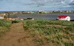
This is the community of Tuktoyaktuk. Welcome.

One way to get to Tuktoyaktuk, would be to fly. If English isn't your language, try a few Inuvialuit languages.

Before you get on the plane, make sure to read a few rules. Do you have warm clothes?

Here's the plane we'll take. This is actually a shot from the Tuk airport.

It's a small plane, so we get to see how the plane is doing.

When you fly to Tuk, you get to see plenty of lakes. This land is remote and rugged.

And you get to see some interesting platforms. Anyone know what/who this is?

This is the airport, with a pingo in the background.

This is the tundra. Trees don't exist, but you get some vegetation. This pic is a bit boring, but note... the grass is very bumpy... that's from the permafrost.

Yes, there are a few road signs. From my understanding they got this, this year.

The community permafrost freezer. Super cool.

Down we go.

In the caves. Each door leads to a family's freezer. The walls are frozen solid. Sorry the picture is blurry.

This is what permafrost looks like. The picture has been rotated. The right of the picture is at the top where the permafrost is a bit more flaky. The left of the picture has solid ice/soil that is frozen solid.

I believe this is caribou in one of the caves.

Fish. mmm....

A Finnish Eskimo. A Finkimo.


I love this piece of art. If you happen to know the name/artist, please let me know. It's of two whales and the deep blue sea.


church.

church

church

church

They used wood to construct the church... guess what, this is inside the church! Yes, they used a hockey stick in the construction.

The end of the highway.

This sunset lasted for hours. Til I visit again. Thanks Inuvik! =)
» Useful Links
Pingo National Landmark -- Parks Canada
Arctic Nature Tours
MacKenzieDelta -- hotel in Inuvik, NWT
Yukon Highway Conditions
Northwest Territories Highway Conditions
Dawson Historical Complex National Historic Site -- Parks Canada
S.S. Keno National Historic Site -- Parks Canada
Dredge No. 4 National Historic Site -- Parks Canada
Klondike Kate's -- restuarant in Dawson City
» National Parks in the Northwest Territories
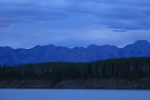
Nahanni National Park, NWT
July, 2008 We never went to Nahanni, but we saw the hils from a distance. This park is a dream trip of mine. 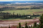
Wood Buffalo National Park, NWT and Alberta
July, 2008 Fun park, but more mosquitos than Pukaskwa NP. |
» Highways in the Northwest Territories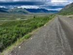

|