CENSUS CD + Maps
Block Group Data and Maps

Last Updated on March 22, 2001

Introduction

Variables

The Census CD+Maps by Geolytics has all 1990 Census variables from the sample questionnaire (Summary Tape File 3A) for all states from the national to the block group level. Among the variables are age, race, sex, marital status, education, income, occupation, poverty, housing value and rent, mortgages, age of homes.

Secondary data sources include population estimates and projections (1997/2002), consumer expenditures (1997/2002) and USA Counties (census variables as well as banking, crime, federal expenditures, social services, and vital statistics for counties only.)

Mapping

A mapping program will illustrate data to the block group level. However, it does not include the street names of census tract or block group boundaries. For 1990 tract and block group street boundaries, use the Reference Maps section of the American Factfinder (http://factfinder.census.gov/) web site. Note that the default is 2000. Use the Legend option to switch to the 1990 maps.

Accessing Census CD + Maps

The Census CD is available to University of Michigan affiliates in two forms. The hard copy is located in the Graduate Library's Documents Center (Do114) and runs on Computer #5.

It is also available on the Library's CITRIX Server (CD-ROM LAN). The CITRIX version requires a helper program installed on the computer. Most library workstations have installed the program. You can install it on your campus or home computer by going to http://www.lib.umich.edu/citrix/census.html and following the instruction.

Once the CITRIX client is installed on a computer, you access the Census CD+Maps by using your web browser. Open: http://www.lib.umich.edu/citrix/census.html. NOTE: you may be asked whether to grant server access to "local client files" when you use this title. You must grant "Full Access" for this title to function properly.

Tutorials

The following tutorials illustrate the software's capacity. The first is for data only; the second for data and maps with examples of downloading.


Block Group Data

1. Identify a library workstation with a CITRIX Client. Use Netscape or Internet Explorer to access http://www.lib.umich.edu/citrix/census.html

2. Open up the Geolytics Program.

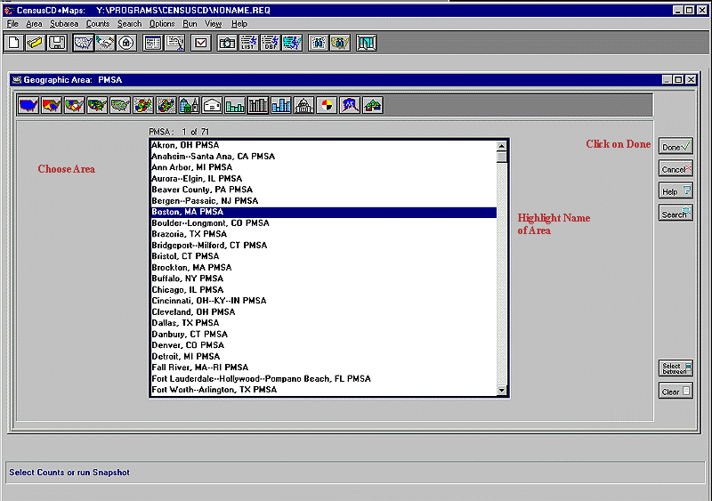
3. Click on Area/Geographic Area/PMSA. Click on Boston PMSA. Press DONE if you only want the Boston PMSA. Do NOT press done if you want to run the Boston results on other PMSAs at a later time.


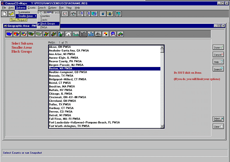
4. Click on Subarea/Smaller Areas and then click on TYPE OF SMALLER AREA. NEVER click on DONE. Clicking on DONE will eliminate further choices.


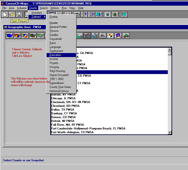
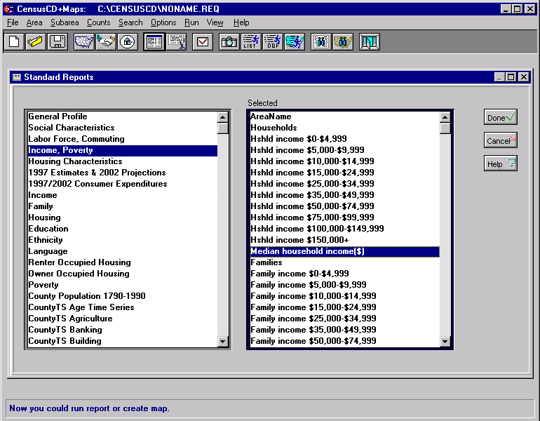
5. Choose Counts, then Standard or Tailored. (Standard Counts gives a lengthy range of variables. Tailored Counts is easier to use when selecting individual variables. This example uses Tailored Counts.) Then click on subject (in this case EDUCATION).


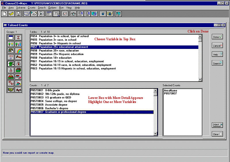
6. Choose a variable in the TOP box. This will expand it in the LOWER box. Choose one or more variables in the LOWER box. Then click on DONE.


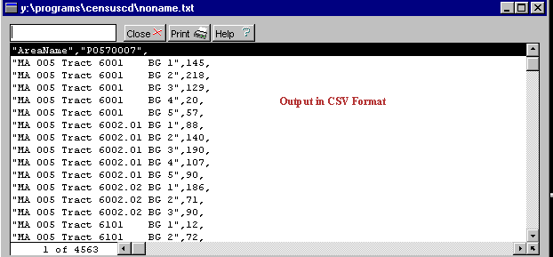
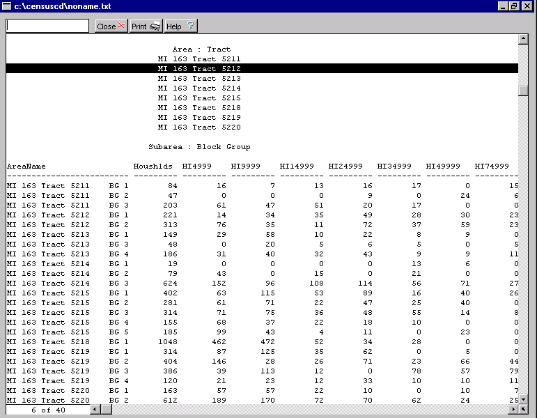
7. Choose RUN and one of the output options.


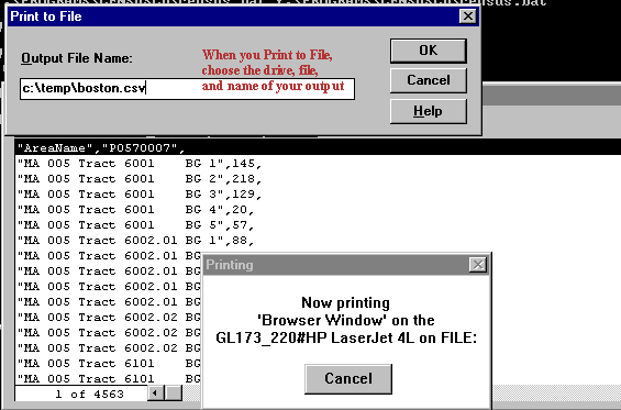
8. The Output can be printed or saved. To save, use the PRINT option rather than File/Save As. Then choose PRINT-TO-FILE.


9. When you PRINT-TO-FILE, name your drive, file, and name.

Block Group Mapping

1. Open up the Geolytics Program.

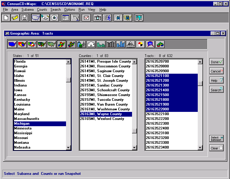
2. Click on Area/Geographic Area/Tracts.

3. In the resulting box, click on Michigan, then Wayne County. You can choose multiple tract numbers (26163/521100-26163/522000) in one of two ways. Either click on them individually OR click on the first (5211) and last (5220), then the Select Between button. Do NOT click on DONE.

Note: In the example above, 26 stands for the state; 163 for the county; 5211-5220 are the tract numbers; the last 00 is a block group digit.


4. From the top menu, choose Subareas/Small Areas/Block Groups. Do NOT click on DONE. DONE will limit your options in the future.

5. From the top menu, choose Counts, then Standard or Tailored. (Standard Counts gives alengthy range of variables. Tailored Counts is easier to use when selecting individual variables. This example uses Standar Counts.) Then click on subject in the lefthand box. To choose ALL of the variables in the righthand box, click on DONE. You can also select ONE individual variable in the righthand box and click on DONE.


6. From the top menu, choose RUN. Options include List Report (plain text format), ASCII (comma-delimited and comma-separated for spreadsheets, DBF (for EXCEL or data base management), and Map. If you select List Report, ASCII, or DBF, the result are all of the income/poverty variables for all of the block groups in the chosen tracts.


7. To download the data to a disk, select PRINT from the data screen (not the File/Save As menu from the main screen) and click on the PRINT TO FILE option. Name your drive, file, and extension (e.g. a:ethnic.dbf).

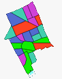
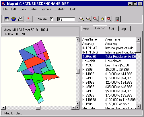
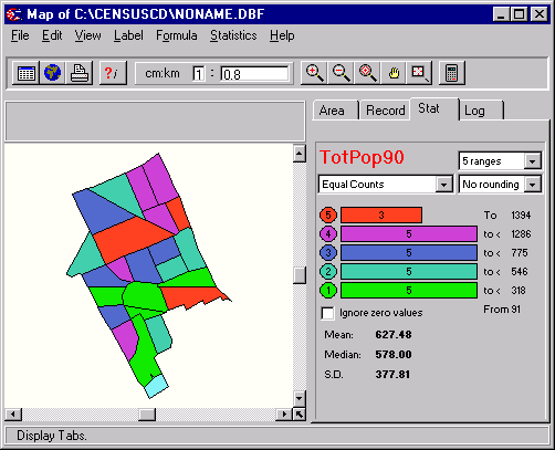
8. You can also create a map. From the top menu, click on RUN/MAP. You will receive a map of all of the block groups in the chosen tracts. Click on the righthand box to change the variable. Run the mouse over the map to get an identification of the block group and tract number as well as the actual data for that area.


9. STAT on the right-hand table describes the data range.


Grace York, Coordinator, Documents Center
The University of Michigan Library
For comments and suggestions, contact govdocs@umich.edu

http://www.lib.umich.edu/govdocs/geolytic.html

Since February 16, 1999 this page has been accessed


[an error occurred while processing this directive]