


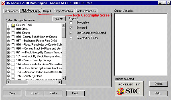
| 040 - State 050 - State-County 060 - State-County-County Subdivision - - 067 - State[Puerto Rico Only]-County-County Subdivision-Subbarrio 070 - State-County-County Subdivision-Place/Remainder 080 - State-County-County Subdivision-Place/Remainder-Census Tract 091 - State-County-County Subdivision-Place/Remainder-Census Tract-Block Group Group 101 - State-County-County Subdivision-Place/Remainder-Census Tract-Block Group-Block 140 - State-County-Census Tract 144 - State-County-Census Tract-American Indian Area/Alaska Native Area/Hawaiian Home Land 150 - State-County-Census Tract-Block Group 154 - State-County-Census Tract-Block Group-American Indian Area/Alaska Native Area/Hawaiian Home Land 155 - State-Place-County 158 - State-Place-County-Census Tract 160 - State-Place 170 - State-Consolidated City 172 - State-Consolidated City-Place Within Consolidated City 230 - State-AlaskaNative Regional Corporation 261 - State-American Indian Area/Alaska Native Area/Hawaiian Home Land-County-County Subdivision 263 - State-American Indian Area/Alaska Native Area/Hawaiian Home Land-County- County Subdivision-Place/Remainder 283 - State-American Indian Area/Alaska Native Area (Reservation or Statistical Entity Only) 285 - State-American Indian Area/Alaska Native Area (Reservation or Statistical Entity Only)-County 265 - State-American Indian Area/Alaska Native Area (Reservation or Statistical Entity Only)-County-County Subdivision 266 - State-American Indian Area/Alaska Native Area (Reservation or Statistical Entity Only)-County-County Subdivision-Place/Remainder 267 - State-American Indian Area (Off-Reservation Trust Land Only)/Hawaiian Home Land-County-County Subdivision 268 - State-American Indian Area (Off-Reservation Trust Land Only)/Hawaiian Home Land-County-County Subdivision-Place/Remainder 280 - State-American Indian Area/Alaska Native Area/Hawaiian Home Land 281 - State-American Indian Area/Alaska Native Area/Hawaiian Home Land-Tribal Subdivision/Remainder 282 - State-American Indian Area/Alaska Native Area/Hawaiian Home Land-County 284 - State-American Indian Area/Alaska Native Area (Reservation or Statistical Entity Only)-Tribal Subdivision/Remainder |
286 - State-American Indian Area
(Off-Reservation Trust Land Only)/Hawaiian Home
Land 287 - State-American Indian Area (Off-Reservation Trust Land Only)/Hawaiian Home Land-Tribal Subdivision/Remainder 288 - State-American Indian Area (Off-Reservation Trust Land Only)/Hawaiian Home Land-County 374 - State-NewEngland County Metropolitan Area 375 - State-NewEngland County Metropolitan Area-Central City 376 - State-NewEngland County Metropolitan Area-County 390 - State-Metropolitan Statistical Area/Consolidated Metropolitan Statistical Area 391 - State-Metropolitan Statistical Area/Consolidated Metropolitan Statistical Area-Central City 392 - State-Metropolitan Statistical Area/Consolidated Metropolitan Statistical Area-County 393 - State [6 states only CT, ME, MA, NH, RI, VT]-Metropolitan Statistical Area/Consolidated Metropolitan Statistical Area-County-County Subdivision 395 - State-Consolidated Metropolitan Statistical Area-Primary Metropolitan Statistical Area 396 - State-Consolidated Metropolitan Statistical Area-Primary Metropolitan Statistical Area-County 397 - State[6statesonlyCT,ME,MA,NH,RI,VT]-Consolidated Metropolitan Statistical Area-Primary Metropolitan Statistical Area-County-County Subdivision 500 - State-Congressional District (106th) 510 - State-Congressional District (106th)-County 511 - State-CongressionalDistrict (106th)-County-Census Tract 521 - State-Congressional District (106th)-County-County Subdivision 531 - State-Congressional District (106th)-Place/Remainder 541 - State-Congressional District (106th)-Consolidated City 542 - State-Congressional District (106th)-Consolidated City-Place Within Consolidated City 550 - State-Congressional District (106th)-American Indian Area/Alaska Native Area/Hawaiian Home Land 551 - State-Congressional District (106th)-American Indian Area/Alaska Native Area(Reservation or Statistical Entity Only) 552 - State-Congressional District (106th)-American Indian Area (Off-Reservation Trust Land only)/Hawaiian Home Land 553 - State-Congressional District (106th)-American Indian Area/Alaska Native Area/Hawaiian Home Land-Tribal Subdivision/Remainder 554 - State-Congressional District (106th)-American Indian Area/Alaska Native Area (Reservation or Statistical Entity Only)-Tribal Subdivision/Remainder 555 - State-Congressional District (106th)-American Indian Area (Off-Reservation Trust Land Only)/Hawaiian Home Land-Tribal Subdivision/Remainder 560 - State-Congressional District (106th)-Alaska Native Regional Corporation 851 - State-3-DigitZIPCode Tabulation Area 852 - State-3-digitZIPCode Tabulation Area-County 871 - State-5-digitZIPCode Tabulation Area 881 - State-5-digitZIPCode Tabulation Area-County |
| Factor | Report | File |
|---|---|---|
| Variables | Entire Tables | Parts of Tables |
| Demographic Profiles | Yes | No |
| Quick Tables | Yes | No |
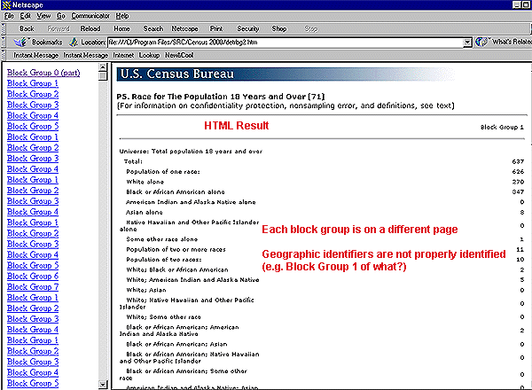
| Geographic Indicators | No | Yes |
| Labels | Names | Codes |
| Blocks and Block Groups | Yes but not Demog. Profiles, Quick Tables, PCT Tables | Yes but not PCT Tables |
| Formats | .htm | .xls .csv .dbf .htm .mdb .db |
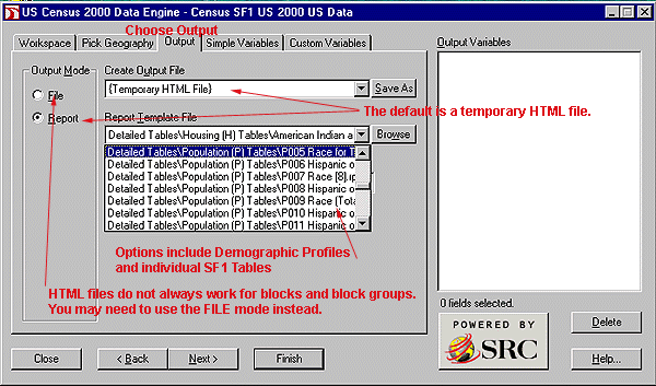
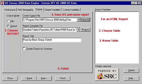
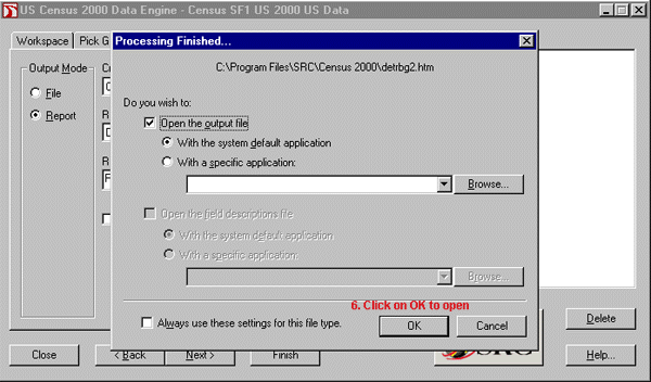
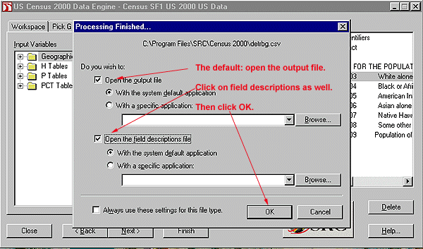
l. Leave the REPORT button checked.2. You can leave the file name as a temporary file or name it in advance by clicking on SAVE AS, then choosing a destination and name.
3. Highlight the table you want.
4. Provide a report title.
4. Click on FINISH.

1. You have already chosen the geography.
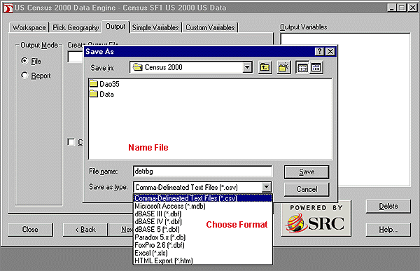
2. Then choose the FILE option. Click on SAVE AS to name your file and choose your format. Yes, you do this before you actually finish your product. File options include:
Comma-delimited text (.csv)
dBASE III (.dbf)
dBASE IV (.dbf)
dBASE 5 (.dbf)
Excel (.xls)
FoxPro 2.6 (.dbf)
HTML Export (.htm)
Microsoft Access (.mdb)
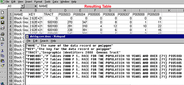
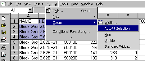
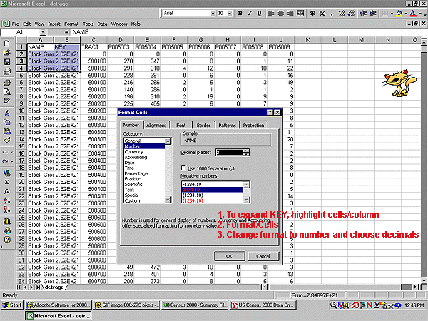
Paradox 5.x (.db)If you plan to use EXCEL, save in .xls format. CSV files imported into Excel display a KEY (geographic identifier) as a scientific number. It does not always display correctly or completely when changed to a general number format.
3. CREATE OUTPUT AS SUMMARY option means you will get one total for all of the geographic areas you've chosen (e.g. one figure for all males 5-9 in a combination of 10 block groups rather than a separate figure for each of the 10 block groups). Not used in this example.
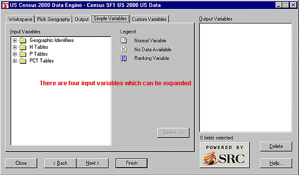
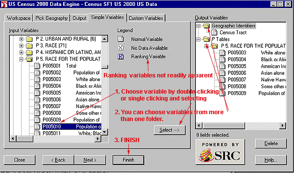
4. Press NEXT or choose simple variables.
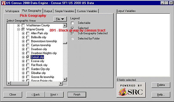
It is usually a good idea to choose geographic indicators for census tracts when the final output is block groups and census tracts plus block groups when the final output is blocks.
| Alaska Native Areas American Indian Areas Area (Land) Area (Water) Block Block Group Census Tract Congressional District (106th) Consolidated Metropolitan Statistical Area County |
County Subdivision Latitude Longitude Metropolitan Statistical Area Place Primary Metrpolitan Statistical Area Region School District (Elementary) School District (Secondary) School District (United) |
State Legislative District (Upper) State Legislative District (Lower) Size Codes State Subbarrio Traffic Analysis Zone Urban Area Urban/Rural Voting District Zip Code Tabulation Area (3-digit) Zip Code Tabulation Area (5-digit) |
POPULATION (P) TABLES - Age, race, sex, households and group quarters characteristics to the BLOCK level.
PCT TABLES - Detailed age and race tables, as well unmarried partner households, to the CENSUS TRACT level.
A printable list of all H, P, and PCT tables appears at: http://www.lib.umich.edu/govdocs/census2/sf1tab.htm
Grace York, Coordinator, Documents Center
University of Michigan Library
Send comments and suggestions to graceyor@umich.edu