Lecture Summary for Tuesday, March 17, 1998
Corresponding Readings in Primack, Richard B. Essentials of Conservation Biology.
Chapter 15: pages 397-417
GAP ANALYSES (GA)
PROTECTING BIODIVERSITY THROUGH ESTABLISHING NEW RESERVES
Gap analysis is an approach based on mapping of vegetation, animals (usually terrestrial vertebrates) and land ownership in order to identify gaps in the network of parks, reserves, and public lands that hopefully protect the biodiversity they contain. The rationale for gap analysis is: X Often we find that many different species, including threatened species, exist outside of protected areas. Indeed, most national parks and other public lands were set aside for their scenic values, and absence of economic values, rather than as reservoirs for biodiversity. X Protecting species one by one is expensive. Often, the majority of limited funds to aid threatened species are directed at a handful of high profile cases; the majority receive little help. X The number of species requiring protection is large. Protecting many species with landscape-level planning should be cost-effective. X Few of the approximately 250+ vegetation types within the USA are well represented on public lands.
The Approach
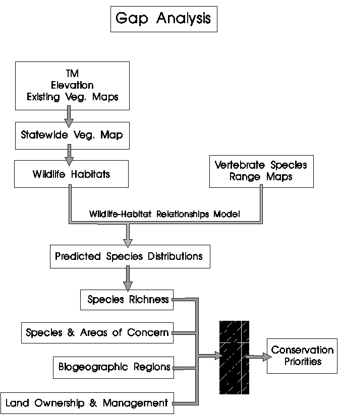
Gap analysis relies on three primary data layers. These are:
The distribution of actual vegetation types, delineated from satellite imagery The distribution of terrestrial vertebrates, predicted from the vegetation distribution by associating individual species with the vegetation that characterizes their habitat The distribution of land ownership
The process can be as simple as placing layers of transparent mylar over a base map, such as a topo map, and tracing the information onto separate layers of transparencies. The first gap analysis looked at the distribution of three species of endangered Hawaiian honeycreepers (forest birds) on the island of Hawaii. It was possible to see the distribution of each bird species, and also locations where all three species coincided. Logically, these areas would be conservation priorities. Although the island had a number of nature reserves, none overlapped the birds' distributions. These maps determined the site for a new reserve.
Extending this approach to a large scale depends on computer mapping of satellite images. Landsat TM (thematic mapper) or other remotely sensed imagery allows the construction of vegetation maps. Landat TM receives seven spectral bands of reflected infrared light, in individual cells or pixels of 30m x 30m. Image classification uses those spectral data to develop a map of vegetation classes, which is compared to ground measurements to improve accuracy. This map and the data it contains are geo-referenced, meaning that every location has a latitude and longitude or some other X-Y grid location. Specialized computer software along with these spatial data and other information make up a Geographic Information System (GIS).
Mapping the distribution of terrestrial vertebrates can be as simple as obtaining range maps from field guides, although this can be inaccurate. A species does not occur in equal abundance, or perhaps at all, everywhere within its range, because the habitat varies greatly from place to place. Animal distributions are mapped most accurately when there is detailed understanding, and perhaps a model, relating their distribution to specific vegetation types.
Mapping land ownership is straightforward, using state and county gazetteers and land ownership records.
Using these data layers and a GIS, one can ask:
What fraction of threatened species occurs within existing reserves? What fraction of each major vegetation type falls within existing reserves? Are areas of highest species richness found within existing reserves? Are areas of high endemism found within existing reserves?
Gap Analysis Flow Chart
Examples of maps
A look at Michigan
Web sites
www.gap.uidaho.edu/GAP/AboutGAP/IntroductiontoGAShort/index.htm
www.gap.uidaho.edu/GAP/AboutGAP/IntroductiontoGAShorter/index.htm