(aka "Archimedes" in the Google 3D Warehouse environment)
The
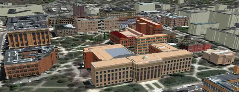
"Diag"--central quadrangle--The University of Michigan, Ann Arbor.
The
current 3rd Edition of the 3D Atlas
of Ann Arbor (http://www.imagenet.org/)
contains real-time 3d (virtual reality) models of the entire city of
Ann Arbor. The files in that eBook cover just under 25,000
buildings in Ann Arbor. A number of files are fully textured;
still others are partially textured; yet others are extruded from GIS
software footprints according to correct heights; and, the remaining
buildings outside the downtown and the university are extruded
according to an arbitrary height. The geometry for all buildings
is there. Recently, the 3D Warehouse
featured the work of "Archimedes" in three of its four "Google Picks"
categories: "Cities in Development"; "Featured Modelers"; and,
"Help Model a City." The latter category is particularly exciting
as it offers cities with full geometries, such as Ann Arbor, an
opportunity to take advantage of free labor from those wishing
exercises for students in texture application using Google SketchUp®
coupled
with photos in Picasa®,
and so forth. Thus, a winning opportunity
is once again created (as it was when municipal authorities began to
embrace GIS software): the city that shares its files wins with
free labor and an expanded spatial information base--university
instructors win with fine real-world scenes to offer students as
modeling exercises. Consider joining the growing group!
Copyright, 2007. All
rights reserved, Insitute of Mathematical Geography.