Presentation
of March 12, 2004 at DDA
Following some input from Kelbaugh, the
following sequence of maps, animations, and virtual reality scenes were
made so that alternative scenarios of future downtowns might be envisioned.
From Kelbaugh:
-
tallest
-
10-15 stories along Huron
-
8-10 stories along
-
Liberty, Maynard to Eaton's
-
N. Main, Depot to M14
-
S. Main, Ashley Mews to Moseley
-
Ashley, William to Kingsley
-
First, William to Kingsley
-
Intersection of Washtenaw and Observatory
-
Setbacks
-
0 front setback for first three stories
-
20' upper story setback after third story
-
10' side yards
-
40' back yards
-
high rise: 15-20 story point blocks
at empty lots in the DDA area. Point blocks are towers with 100'
by 100' floor plates.
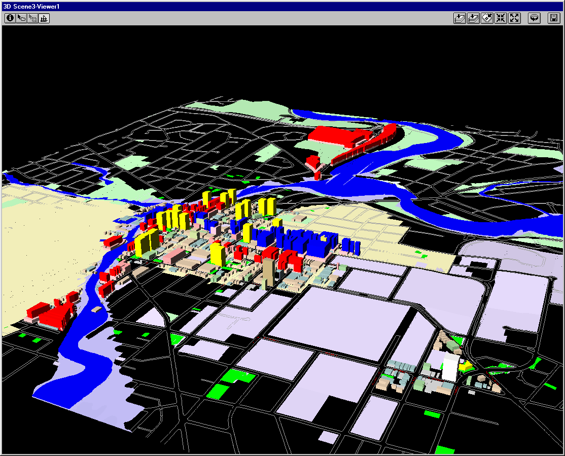
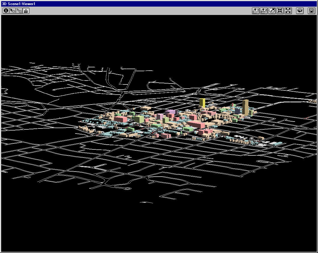
On the maps below, the yellow buildings
are the point blocks and are 20 stories tall. The blue buildings
are the upper story setbacks on Huron Street and they rise to a height
of 15 stories. The red buildings are all the other upper story setbacks
and they rise to a height of 10 stories. The pink buildings are the
three story bases for the red and blue upper level parts. Each story
is 12.5 feet. The scene is draped over a Triangulated Irregular Network
formed from City contour maps (at a five foot contour interval).
The sun is in the South at a "high" position.
Aerial view from the southeast:
Lower aerial view from the southwest:
Animation of different combinations of
buildings, viewed from the southwest:
Virtual Reality files (load Cosmo Player--Windows
95 version on your non-networked PC--in Netscape 4.7x or Internet Explorer).
Drive around in these files:
VR1:
Existing buildings with only yellow point blocks added (built on parcels
that are currently vacant).
VR2:
Existing buildings with only pink, 3 story buildings added as bases for
possible further upper story building. Many of these are on parcels
that already contain buildings.
VR3:
Existing buildings with pink and red buildings added.
VR4:
Existing buildings with pink and blue buildings added.
VR5:
Existing buildings with pink, blue, and yellow buildings added.
VR6:
Existing buildings with pink, red, and yellow buildings added.
VR7:
Existing buildings with pink and yellow buildings added.
VR8:
Existing buildings with pink and red buildings added.
VR9:
Existing buildings with pink, red, blue, and yellow buildings added.
Associated Excel files: the attribute
table underlying each layer measures area. When footprint areas are
multiplied by number of stories, it is easy to calculate total number of
square feet (with the units in the GIS set to feet).
-
Link
to Excel file of buildings, as they are now.
-
Link
to Excel file of point blocks
-
Link
to Excel file of pink buildings (3 story)
-
Link
to Excel file of blue buildings: calculations subtract out the three
stories of the pink base
-
Link
to Excel file of red buildings: calculations subtract out the three
stories of the pink base
-
Link
to Excel file of building at Washtenaw and Observatory.
The process of making maps is a creative
one: thoughts occur as the process proceeds. Here are a few
thoughts:
-
Parcels that lay along the suggested streets,
but that also fell into one of the following categories, were not included
in the maps above:
-
in an historic district
-
in a park
-
in public land
-
in a floodway
-
in a floodplain (the centroid of the parcel
contained in the floodplain)
-
Some parcels were too small, given the setbacks;
sometimes, these were combined with their neighbor.
-
Corner lots have no rear setbacks--two orthogonal
side setbacks.
-
Corner lots make greater use of the land
-
Corner lots are desirable for parcel amalgamation,
because an interior lot that joins to a corner lot loses the rear yard
setback requirement (if symmetric).
-
Parcel amalgamation, desirable perhaps for
building large tall buildings, may squeeze out the small merchant and the
"charm" of downtown.
-
Other lots:
-
On E. Huron, some 15 story buildings on the
north side of the street back right into residential outside the DDA...might
be a problem?
-
Same idea as above when tall building abut
Historic District parcels (that do not already contain tall buildings).
-
Issues remaining:
-
Accuracy of digitizing can be improved, especially
in regard to setbacks
-
Parcel amalgamation
-
Eliminate duplication in databases, either
within a single one from digitizing the same parcel twice, or between them,
between old and new buildings.
-
Need for more information from decision makers...more
input is good...are displays on GeoWall or CAVE desired?
-
Field and other checking of maps is an ongoing
process.
Sandra L. Arlinghaus.
Solstice: An Electronic Journal of Geography and Mathematics,
Institute of Mathematical Geography, Ann Arbor, Michigan.
Volume XV, Number 1.
http://www.InstituteOfMathematicalGeography.org/