|
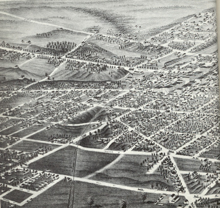
Bird's Eye Sketch of a portion of Ann Arbor, c. 1880. Note railroad bed running north to south and prominent stream bed of Allen's Creek. |
Context: Physical The city of Ann Arbor is located approximately forty miles west of Detroit, Michigan. The project site is situated to the west of the downtown area of Ann Arbor. The landform on which the project site is found is a glacial moraine, formed as part of the Fort Wayne Moraine approximately 14,000 years ago (Albert, 1986). Portions of Allen's Creek and tributaries of Allen's Creek flowed through the project site to the nearby Huron River before they were placed underground in drain pipes in the 1920s. Prior to colonial settlement in the first half of the 1800s, the vegetation likely consisted of Beech-Sugar Maple and/or Oak-Hickory forests as well as prairie ecosystems (Albert, 1986). Though the bird's eye sketch at the left does not illustrate pre-colonial settlement, it does indicate the location of Allen's Creek and the pattern of development in clusters along major routes and in the center of Ann Arbor. |