Tornado Siren Location
Ann Arbor, Michigan
Sandra Lach Arlinghaus
The University of Michigan
with input from those noted
below.
sarhaus@umich.edu
http://www-personal.umich.edu/~copyrght
Different strategies for locating systems of sirens exist in different
locales across the nation. In Ann Arbor, and elsewhere, sirens noise
is designed to alert citizens in the outdoors. Citizens who are indoors
may hear the sirens but the requirement is that people outdoors be able
to hear them. Thus, spacing requirements between sirens becomes important.
When there are barriers to overcome (all else being equal), such as topography,
buildings and street noise, one might expect sirens to be required to be
more closely spaced than in flat, open countryside. Indeed, a brief
review of municipal requirements on the world wide web reveals that Oakland
County, Michigan views each siren to be capable of covering about a one
mile radius. The Baltimore City Fire Department selects spacing at
3200 feet.
The sequence of animaps below, of Ann Arbor, suggests a locational strategy
for pinpointing positions for new sirens.
In this first animated map, Figure 1,
-
the red dots show the location of the existing system of sirens.
-
The light green circles are buffers of radius 3200 feet, the Baltimore
standard. Employing the Baltimore standard provides continuous central
coverage with gaps at the perimeter.
-
The light yellow circles are buffers of radius one mile, the Oakland County
standard. Employing the Oakland County standard provides a continuous
block of coverage. As new areas come in to the city in 2007, as per
boundary agreements, new sirens will need to be added to maintain coverage.
-
The red outlines of polygons, in a sort of bubble foam, are outlines of
the Dirichlet tesselation on the fire stations. The Dirichlet polygons
are mutually exclusive and cover the entire area in the one mile buffer.
Pick any point within the one mile buffer. Note which Dirichlet polygon
contains it. Thus, the siren in the same Dirichlet polygon as the
selected point is the siren closest to that selected point. Each
Dirichlet polygon contains all the points closest to the siren in that
polygon.
Figure 1. Red dots show existing tornado siren locations.
Green circles use the coverage radius employed by Baltimore, MD; yellow
circles use the coverage radius employed by Oakland County, MI. |
In the second animated map, Figure 2,
-
The red dots and the Dirichlet tesselation are as above.
-
Successive buffers have radii of 1000, 2000, 3000, 4000, and 5000 feet.
Figure 2. Spacing between successive buffers of sirens
is 1000 feet. |
In the third animated map, Figure 3,
-
The red dots and the Dirichlet tesselation are as above. The white background
has been removed, inverting the emphasis on the road network.
-
Successive buffers have radii of 1000, 2000, 3000, 4000, and 5000 feet.
-
Streets enter the picture along with buffers, showing zones of connectivity
and perhaps suggesting emergency routes in the 3000 or 4000 foot buffer
level. There is a northwest arterial that is entirely contained within
the 4000 foot buffer. On the east side, routes through the southeast/central
(Ann Arbor Hills) area show strong coverage.
Figure 3. In this view, connectivity of the road network,
already within earshot of existing tornado sirens, is emphasized. |
Finally, where might one consider locating new sirens (Figure 4)?
-
The 5000 foot view shows a gap in coverage just south of Pioneer High School,
east to the U. of M. golf course.
-
Within the Dirichlet tesselation, highest priority might therefore (all
other things being equal) be given to putting a siren in the gap; indeed,
golfers are an important target population!
-
Outside the Dirichlet tesselation, highest priority might therefore be
given to the gap at the right edge of the tesselation that is within the
freeway ring but is as yet uncovered by a siren. The location for
a new siren was found by digitizing the uncovered area, calculating the
centroid of the digitized region, and then using the centroid as the proposed
siren location. In implementation, it is likely that actual position
will not follow centroid location exactly as one factors in property rights,
ease of siren maintenance/access, and so forth.
The cyan (turquoise) sets of concentric circles in Figure 4 fill these
two gaps.
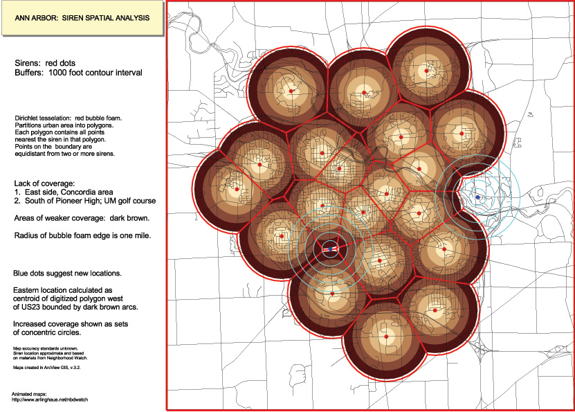
Figure 4. Cyan concentric circles targe locations for
two new tornado sirens. |
| Click here for a link
to
an interactive map made using ImageMapper 3.1 from Alta4.com
. Click on a dot on the linked map. Portions of the underlying
database associated with that dot will pop up next to the map. The
entries in the database are hypothetical and are present to suggest the
range of power of this sort of map for organizing data. There is
no need for any extra plug-in so that users who are NOT administrators
of a machine may also have access to municipal files, from their local
public library, public university, or elsewhere. |
Directions for future research:
-
Contour map of city
-
Triangulated Irregular Network (TIN) made from contour map to show topography
-
Superimposition of sirens on topographic map
-
Recommendations for siren location or relocation based on this finer analysis.
|
Input from:
-
Matthew Naud, Environmental Coordination Services, Director, City of Ann
Arbor;
-
Merle Johnson, Information Technology Services, City of Ann Arbor;
-
Adele ElAyoubi, Neighborhood Watch Coordinator, City of Ann Arbor Police
Department;
-
Karen Hart, Planning Director, City of Ann Arbor.
Oakland County, Michigan
http://www.co.oakland.mi.us/ems/program_service/torn_siren.html
Baltimore, Maryland, Fire Department
http://www.ci.baltimore.md.us/government/fire/pr021016.html