The Possibility of Extending the Streetcar Line in Kagoshima City, Japan
Makoto Noguchi
Masters Student, Urban Planning
Taubman College of Architecture and Urban Planning
The University of Michigan

More and more cars are running in many cities.

Although the car is a very convenient vehicle, it causes serious problems inside city:  traffic jams, car accidents, air and noise pollution, and so on. 

The streetcar can be one of the solutions for these problems. 

It does not give off gas in the city, it does not cause congestion, it can be friendly to the elderly, to children, and to disabled people. 

In this project, I analyze the existing streetcar line in my hometown of Kagoshima, Japan, as an alternative for cars, 
and begin to consider the possibility of extending streetcar lines, in order to utilize this facility more effectively.  The population of Kagoshima, as of October, 2002, is over 550,000 and Kagoshima is the 18th largest city in Japan.

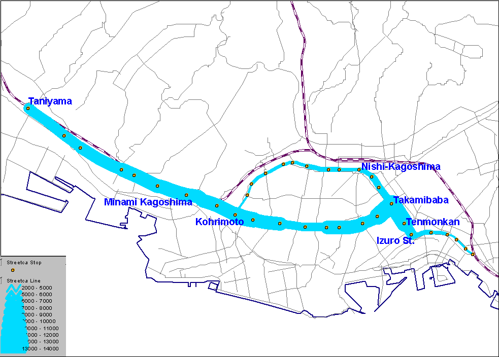
The map to the right is a map I digitized from a paper map of Kagoshima (2002 source).  It covers about 30km from left side to right side.  Orientation is north to the right and tipped very slightly toward the top edge. 

In this paper, based on a larger project, the role of an animated map is emphasized. 

Kagoshima City, Japan.


In Kagoshima City, the streetcar line runs from the Central Business District (CBD) to the Southern Residential area. The total length of streetcar lines is 13.1km. Kagoshima City is a car-oriented city:  most people use cars. Walking comes second. About 18% of people use the public transportation system. This fact suggests that  more convenient public transportation systems might prevent  increasing car usage. 

The theme of this paper is to begin to identify The Possibility of Extending the Streetcar Line in Kagoshima City, Japan. In order to develop the recommendation, it is necessary to conduct a demand analysis. One important factor in that analysis is to assess the current usage (demand) of streetcar lines.  Thus, I will investigate, using animated maps, the current usage (demand) for streetcar lines.

The animated maps below show current streetcar usage: thicker lines (Figure 1) indicate heavier flows of passenger traffic [ed. much as maps of the Napoleonic armies traced declining numbers of soldiers on the eastward thrust to Russia].  In Figure 2, larger circles at streetcar stops mean heavier passenger usage. The survey was conducted on May 18, 2001, by Kagoshima City Transport Company. Data includes all passengers over 5 years old on that day.

The remarkable fact is that the stop with the most passengers' usage is not in city center, but in the suburb, Taniyama, which is located at the south edge of the streetcar  line. That implies that the Taniyama streetcar stop is used not only by Taniyama area residents, but also by the residents around Taniyama area. 

The other stops with many passengers' usage are more of the sort one might expect:

  • City center; Tenmonkan, Izuro, and Takamibaba, in which there are many offices and commercial facilities
  • Transit center; Nishi-Kagoshima Station (largest heavy rail Station in Kagoshima City), and Kohrimoto (another streetcar line comes to this point) 
Clearly, any plans for future extensions of this streetcar line should consider the demographics of Kagoshima City spread across space at a number of timepoints as well as, perhaps, the decision-making behavior of Taniyama and nearby residents.


Figure 1.  The Number of Passengers, by Each Streetcar Line Segment.


Figure 2.  The Number of Passengers, by Each Streetcar Stop.