The
Perimeter Project, Part I:
Fragile Lands Protection
Using Cemetery Zoning and Creative Memorialization
"Not marble, nor the gilded monuments
Of princes, shall outlive this powerful rhyme;"
William
Shakespeare, Sonnet #55
Sandra L. Arlinghaus
Adjunct Professor of Mathematical Geography and
Population-Environment Dynamics
School of Natural Resources and Environment
The University of Michigan
and
William E. Arlinghaus
General Manager
Chapel Hill Memorial Gardens
Grand Rapids, Michigan
Associated Google
Earth file for interactive viewing: download.
The file to download
will remain more current (as it is updated) than will the static images
below that were drawn from it in June of 2009.
General
Vision
The world's most environmentally fragile lands
are in
critical need of protection. Many of
these lands are coastal (hence, "Perimeter" Project); many are in
developing nations. Often these lands have
great natural scenic
beauty and are therefore prized targets for real-estate developers. Zoning is a strong way to control land uses;
zoning, however, can be changed by local municipal authorities in
response to
short-term fluctuations in the economy and political agendas. The most immutable zoning category in most
countries of the world is one that is placed on the lands where the
dead are
buried. Cemetery zoning offers the best protection for land as well as
for people.
Cemeteries in the U.S.A. have trust funds in
place for
perpetual care and maintenance of cemetery lands. This
feature, itself, makes the zoning the most desirable with
regard to protecting lands. Despite
zoning and trust-funding practice, much of modern American burial
practice
actually harms the land: embalming
fluid, steel, copper, bronze, hardwood, and reinforced concrete, are
typically
buried along with the body. What we
seek, in the broader "Perimeter Project" is to create a coastal rim
of the world's fragile lands protected by trust-funded cemetery status
AND by
environmentally sensitive burial practice. What we describe in
Part I of a series of essays and their implementation is a pilot
project currently underway as a first step toward this "General
Vision." The entire project, as envisioned at the outset, is one
of global proportions and is one that will unfold over many years
Contemporary
Burial Practice in the USA
Burial of the embalmed body in a casket, inside
a vault,
inside the Earth, seems to offer a sense of permanence and security to
loved
ones. Burial is also a consistent form
of handling the body within many western religions.
Monuments, marble or otherwise, marking the location of
the burial have become
standard. Memorialization of the life is
etched in
stone.
In recent years, cremation has become
increasingly
acceptable. It often appeals to those
who worry about environmental sensitivities associated with putting
embalming
fluids, metals, hardwoods, and concrete into the ground.
Cremation does little, however, to improve
the ground. So-called "green" or "natural"
burial, which is "new" within contemporary US culture is both
environmentally sensitive and good for the earth. A
naturally decomposing human body inside a shroud or a
biodegradable container, buried within the Earth, continues to
contribute for a
number of years to the welfare of the land and the vegetation. From an environmental and from a marketing
perspective, this form of environmentally sensitive burial is the best. Often, however, there is no memorialization
associated with either cremation or green burial.
Green burial, while it may be "new" to many
Americans, certainly is not a new idea. It
is, in fact, the oldest form of burial. How
then, did we get involved in this unnecessarily complicated approach,
one might
ask? The answer is "Marketing"--make
people
believe
blindly that this form of ceremony is the "proper" way to handle the
death of a loved one. What marketing
can do, it can also undo. The biggest marketing issue in the USA
separating
current from environmentally sensitive burial practice is that of
memorialization.
|
Summary:
The merits and drawbacks of three
forms of body
management after death
- Contemporary US
burial practice
- Merits
- Offers a
permanent, trust-funded physical memorial--marble tombstone, for
example.
- Fits with many
conservative prevalent US religions
- Drawbacks
- Harms the land in
terms of the chemicals/metals it places in the Earth
- Gives nothing
back to the Earth while occupying its parcel of land
- Horizontal burial
orientation (as the default mode in many cemeteries) maximizes
footprint on the land
- Cremation
- Merits
- Does not harm the
land
- May make no
demands for a parcel of land, if ashes are scattered; minimal otherwise.
- Drawbacks
- Has no permanent
memorial if the ashes are scattered; generally, only a group memorial
otherwise
- Does not fit with
many conservative prevalent US religions so that near-universal
adoption
is not an option
- Cremation is
unappealing to many.
- Green burial
- Merits
- Does not harm the
land
- Does give back to
the Earth while occupying its reusable parcel of land.
- Vertical burial,
as default orientation, would reduce burial plot footprint
- Does fit with
many conservative prevalent US religions
- Marketing
advantage: Green burial appears more
appealing than cremation and has none of the problems of conventional
burial. It has seen limited use in Europe
(particularly the UK and very limited use in the US).
This option has many attractive selling
points--one goes on living by fertilizing the soil and
protecting the
valued lands of the world." Preliminary
contacts with consumers suggest an 80% approval rating of the idea.
- Drawbacks
- May have no
permanent memorial.
|
Permanent
Memorialization: the Key to a Successful Pilot Project
The table above shows clearly that permanent
memorialization is the key to moving
from damaging
burial practice to environmentally sustainable practice: either
cremation or
green burial. Cremation has more
limited marketing potential than does green burial.
Nonetheless, in Michigan over the past ten years the
demand for
cremation has multiplied 10 fold. What
is needed to take advantage of the more responsible and indeed,
cheaper,
alternatives of cremation and green burial, in a marketing climate that
is ripe
for these approaches, is a solution to the memorialization problem that
comes
from the scattering of ashes and certain styles of green burial.
A natural answer to the lack of a permanent physical
marker
is to provide a permanent virtual marker
as a tribute and memorial to
the life
of an individual. We use Google
Earth and contemporary electronic networks to archive these markers in
space and time, in a tested format (since 2002), using a
corporate structure that is already established in imitation of
traditional
cemetery non-profit trust funding (Archived Memorials Online: http://www.MyLovedOne.com).
Our current pilot project is based on land
where we already have a foothold, in Grand Rapids, Michigan.
Since January 1 of 2009, all sales of burial or cremation include,
necessarily, a spot in a virtual trust-funded cemetery.
Individual basic virtual markers are placed on the Google Earth
site. The figures below show animated sequences of screen
captures, or static shots (as appropriate), from
the Google Earth virtual cemetery for the Grand Rapids site, which is
contained within the broader virtual cemetery linked above.
The reader wishing to have the full experience, both audio and visual,
must load the .kmz file into Google Earth and use that as a browser.
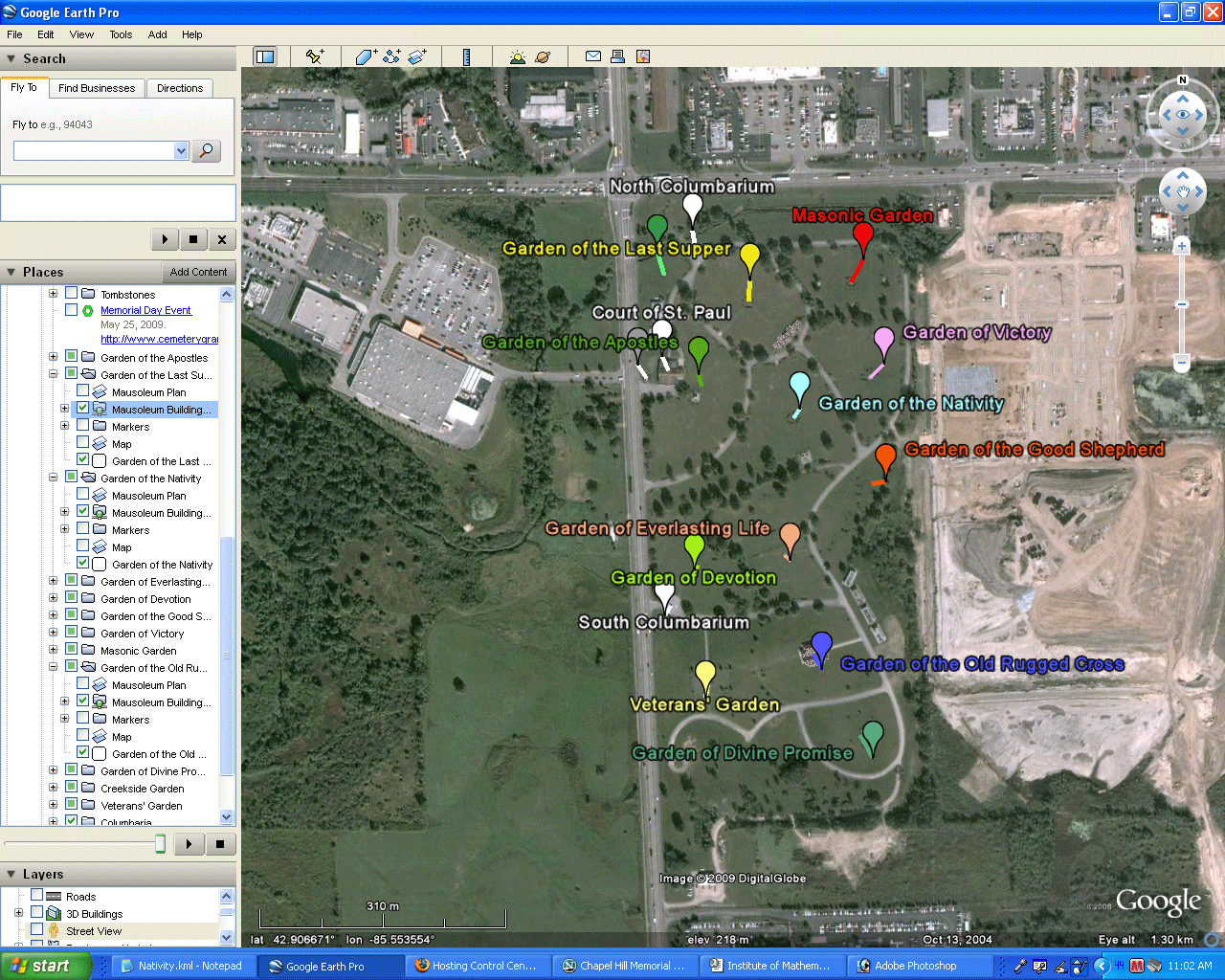
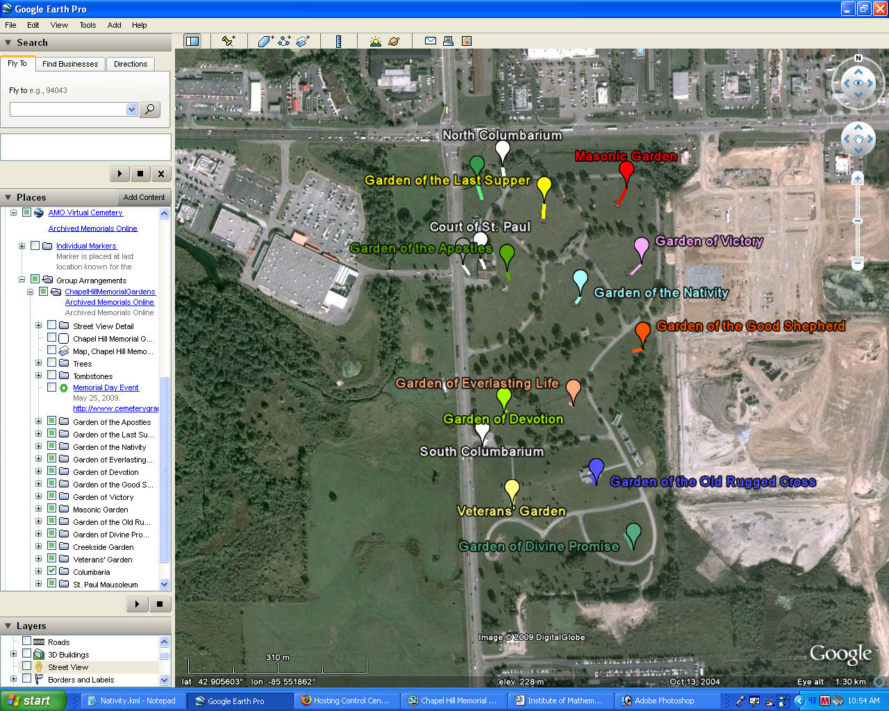
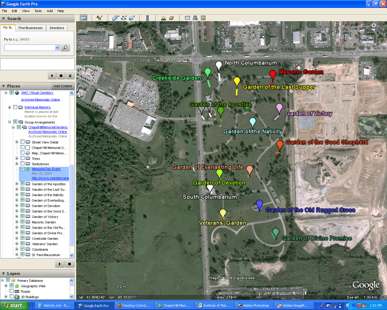
The first step in creating an online virtual
cemetery is to locate it in Google Earth and mark various broad
geographic components within it. Thus, in Figure 1:
- Figure 1a: Placemarks have been
added in Google Earth to show the locations of the various Gardens
within the cemetery.
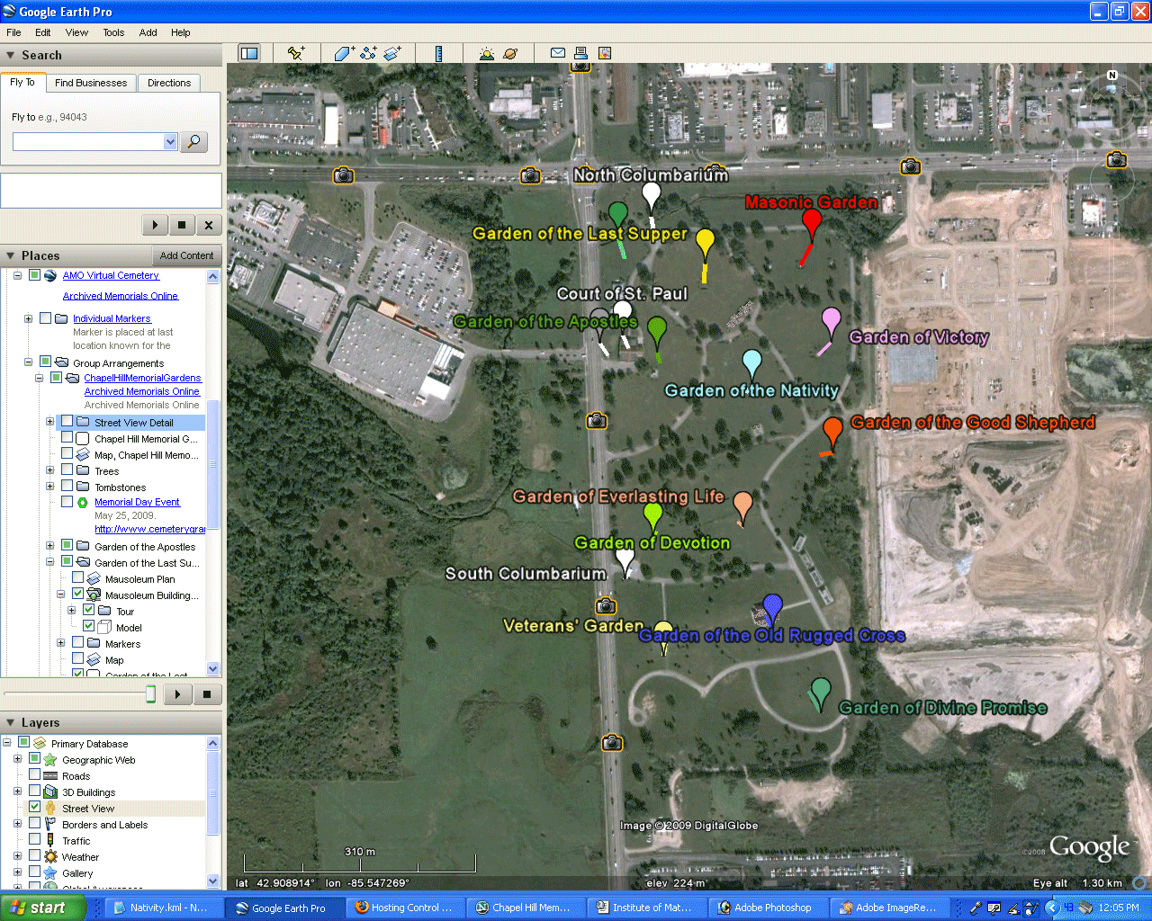
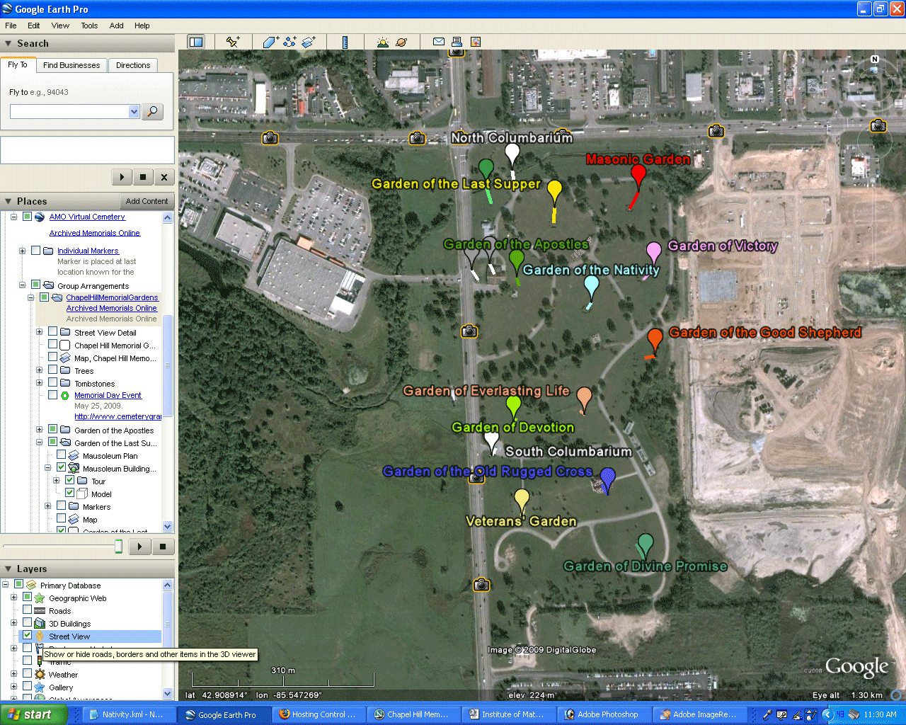
- Figure 1b: Chunky 3D buildings
have been added, using Google SketchUp, to represent mausoleums.
These buildings were then uploaded into Google Earth and are correctly
geo-referenced there. To keep file size manageable, the buildings
have been installed as "network links"; thus, one must be on the
internet otherwise the buildings will not load. As development
continues, photographic textures will be added to the sides of
buildings and architecture will be modeled according to photographic
evidence and field-checking.
 .
|
Figure 1b.
|
In Figure 1b, it was
helpful to zoom in to see the virtual 3D simple mausoleum structures
rise from the GoogleGlobe. What the zoom-ins also showed,
however, was how plain the landscape appears. Naturally, one
might wish a more detailed view. To overcome this difficulty from
public streets and other public access, Google Earth has a feature
called "Street Views" which shows camera views of detail surrounding
the streets. On private property, such as in the interior of a
cemetery, one must create such views from field photos and then convert
them, using simple code, into computer files that will show up in
Google Earth. These views may be presented on a flat billboard,
on the inside of a cylinder, or on the inside of a sphere. The
default set that comes in Google Earth presents local panoramas within
spheres. At the present, we present added camera views on
billboards. These ideas are displayed in a visual sequence in
Figure 2.
- Figure 2a: Clicking on the
"Street Views" in the default loadset shows only views of the cemetery
from the street.
<>Figure 2b:
Field photos were taken of selected elements of the interior of the
cemetery. These photos were mounted on 3D "billboards" to show
the detail as added street views. Because the opacity of these
billboard views can be adjusted, one can check the location of these
views against the chunky buildings as shown here for the Garden of the
Nativity.
- Figure 2c: The code for one
such billboard view (Garden of the Nativity).
 .
|
|
Figure 2b. |
<?xml
version="1.0" encoding="UTF-8"?>
<kml xmlns="http://earth.google.com/kml/2.2">
<PhotoOverlay>
<name>Garden of the Nativity</name>
<visibility>0</visibility>
<description><![CDATA[<html>
<body bgcolor="#000000" text="yellow">
<large>
<a
href="http://www.cemeterygrandrapids.com/MemorialDay2009/Nativity01.jpg">Link</a>
to view in the associated browser window.
</large>
</body>
</html>]]></description>
<Camera>
<longitude>-85.546913</longitude>
<latitude>42.910479</latitude>
<altitude>5</altitude>
<heading>132</heading>
<tilt>88.80375917000001</tilt>
<roll>0</roll>
</Camera>
<Style>
<IconStyle>
<Icon>
<href>http://maps.google.com/mapfiles/kml/shapes/camera-lv.png</href>
<refreshMode>onExpire</refreshMode>
</Icon>
</IconStyle>
<ListStyle>
<listItemType>check</listItemType>
<ItemIcon>
<state>open closed error fetching0 fetching1
fetching2</state>
<href>http://maps.google.com/mapfiles/kml/shapes/camera-lv.png</href>
</ItemIcon>
<bgColor>00ffffff</bgColor>
<maxSnippetLines>2</maxSnippetLines>
</ListStyle>
</Style>
<Icon>
<href>http://www.cemeterygrandrapids.com/MemorialDay2009/Nativity01.jpg</href>
</Icon>
<ViewVolume>
<leftFov>-25.0019</leftFov>
<rightFov>25.0019</rightFov>
<bottomFov>-14.66</bottomFov>
<topFov>14.66</topFov>
<near>0.7</near>
</ViewVolume>
<Point>
<altitudeMode>relativeToGround</altitudeMode>
<coordinates>-85.546913,42.910479</coordinates>
</Point>
</PhotoOverlay>
</kml>
Figure 2c. Code for camera
"billboard" view of the Garden of the Nativity. |
The camera billboard views of the interior of
the cemetery offer the driver a way to fix visual benchmarks.
There is, however, often a need in navigating a real cemetery to have
even more detail. Thus, we begin to incorporate even more detail
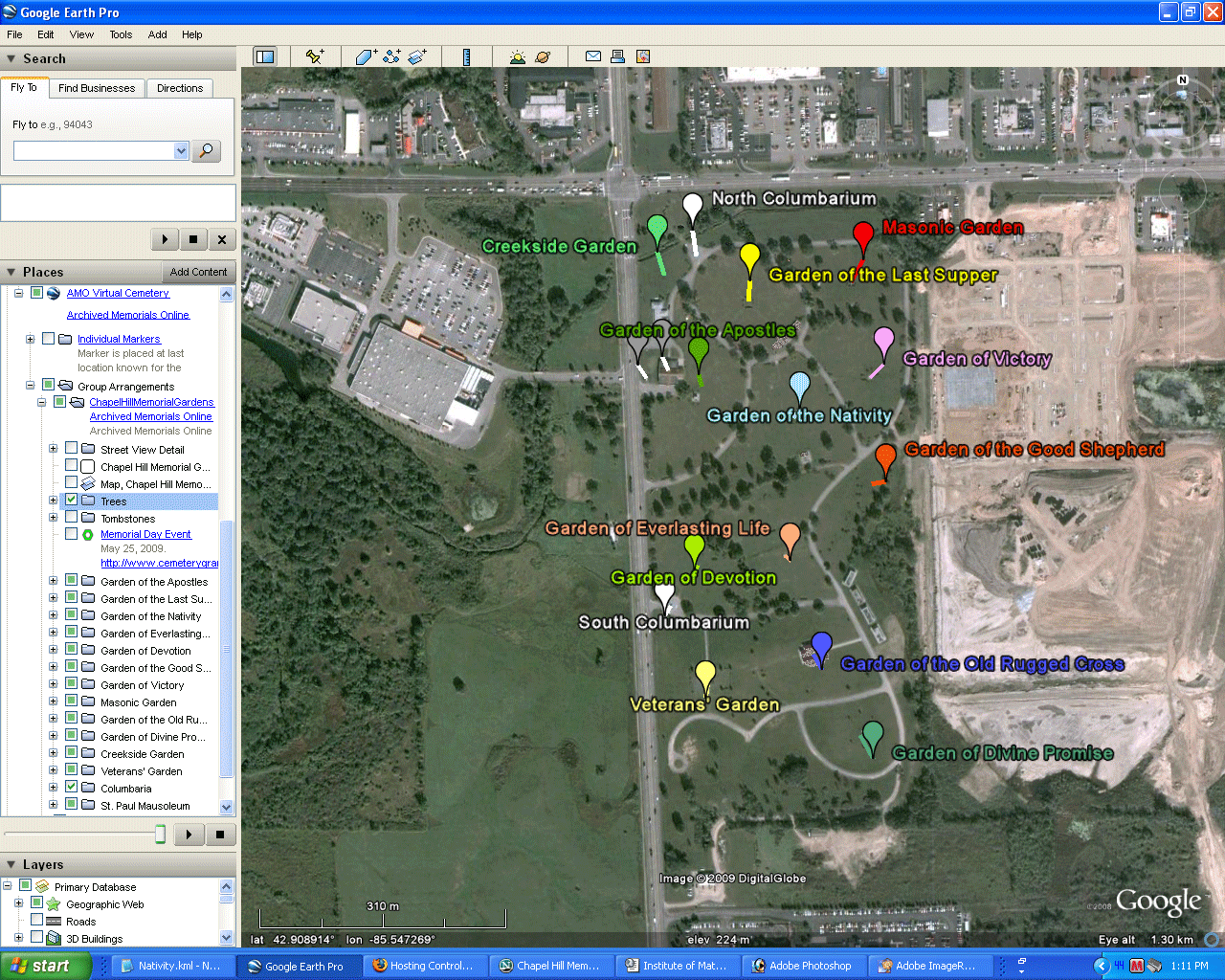
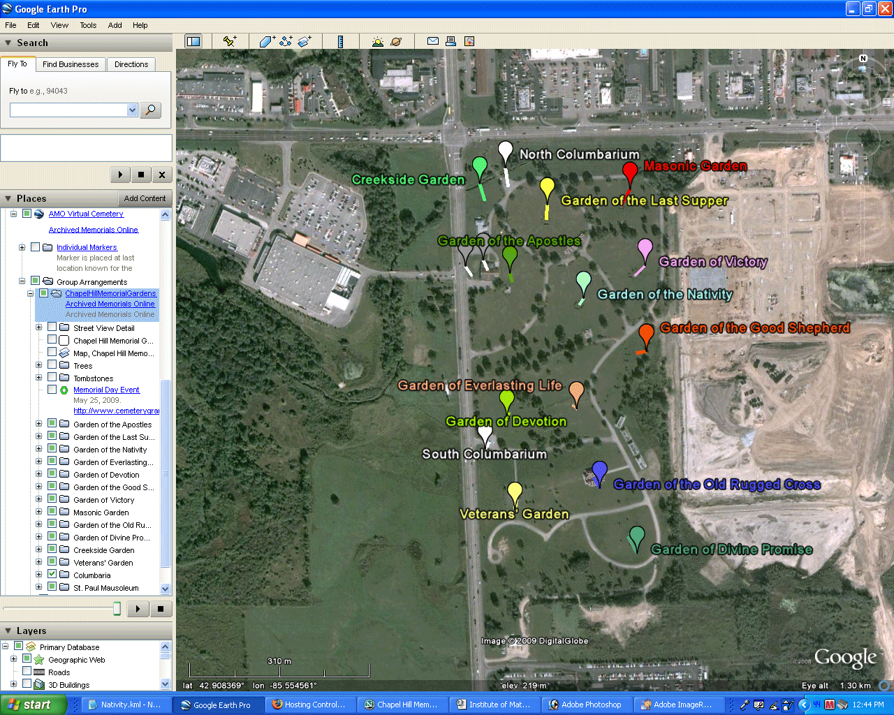
in the virtual cemetery. In Figure 3:
- Figure 3a: Maps of lot
locations are inserted in each Garden
- Figure 3b: 3D trees are
added. The Google 3D Warehouse has many useful items of this
sort: trees, shrubs, flowers, and so forth. To create a
fuller looking tree, select two copies of the same tree and orient one
of them at 90 degrees to the other (or three at 60 degrees--but be
careful of increasing overall file size too much). As above,
network links are used to keep file size manageable.
- Figure 3c: Special events at
the cemetery can be kept alive. This figure shows part of a
Memorial Day ceremony. Configure your browser in relation to
Google Earth as you wish. We have chosen to have it come up in a
frame at the bottom of the Earth in order to fit all in a single screen
shot. In Google Earth, one can also listen to the accompanying
music while watching the animation or while driving around the virtual
cemetery.
 .
|
|
Figure 3b. 3D
trees offer a sense of realism when walking around the virtual
cemetery. |
|
|
|
Solstice
was a Pirelli INTERNETional
Award Semi-Finalist, 2001 (top 80 out of over 1000 entries worldwide)
One
article in Solstice was a Pirelli
INTERNETional Award Semi-Finalist, 2003 (Spatial Synthesis Sampler).
Solstice
is listed in the Directory of Open
Access
Journals maintained by the University of Lund where it is
maintained
as a "searchable" journal.
Solstice
is listed on the journals section of the website of the American
Mathematical
Society, http://www.ams.org/
Solstice
is listed
in Geoscience
e-Journals
IMaGe
is listed on the website of the Numerical Cartography Lab of The Ohio
State
University: http://ncl.sbs.ohio-state.edu/4_homes.html
Congratulations
to all Solstice contributors.
|
|