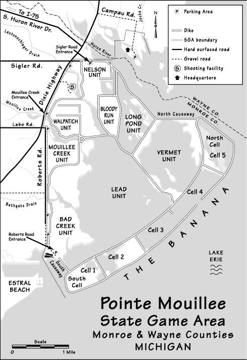
Map 1
Map 2
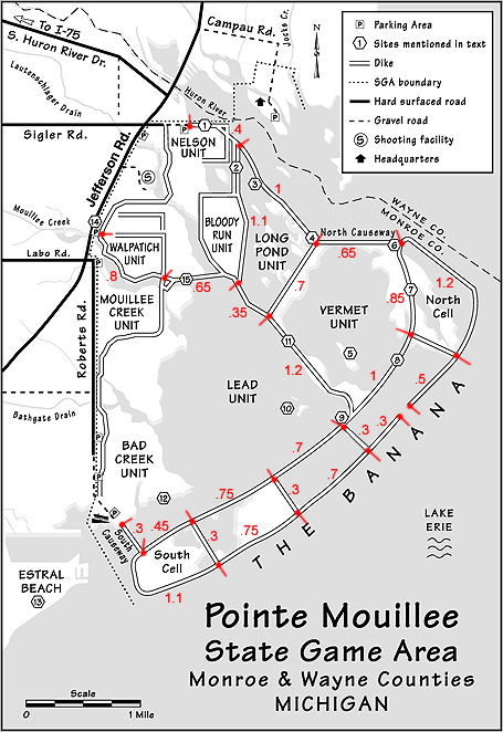
Map 2
Go to location maps.
Return to the Pte. Mouillee bird checklist page.
Map 1 - There is parking and walking (or bicycle) entrance at three locations: Sigler Road (nearly secluded), Mouillee Creek (U.S. Turnpike Rd./W. Jefferson Ave.), and Roberts Road (secluded). Do not leave anything of value in sight in your vehicle as there have been numerous breakins, particularly at the Roberts Rd. parking lot.
The road marked Dixie Highway on Map 1 is actually W. Jefferson Ave. (or U.S. Turnpike Rd.), as marked on Map 2.
Campau Rd., off W. Jefferson one mile north of Sigler Rd., leads to the Pte. Mouillee SGA headquarters. There is a large parking lot there and open views of water in three directions. Depending on season this is a good location for viewing waterfowl, gulls and terns, and raptors.
Map 2 - The second map shows walking distances in miles for each section of the dike roads. Be sure you have adequate sun protection and drinking water before engaging on a long trek. At times you may need protection from mosquitoes and biting flies.
The best shorebirding is generally in Cell 2 and Cell 5 of "the Banana" and in the Lead Unit. You will probably want to pick your entrance to minimize walking distance to your destination--probably Sigler Rd. for Cell 5 and Roberts Rd. for Cell 2 and the Lead Unit. The walk from the Roberts Rd. parking lot to the tip of Cell 5 and back is over eight miles.
Much of the area shown as water on these maps is marsh, not deep water of Lake Erie.
Thanks to the Erie Shores Birding Association for these maps, to Melinda Stamp, who created the maps, and to Tim Smart for the mileage figures on the second map.
Click on either map below to get a separate, printable version.
Map 2
Map 2
Go to location maps.